
| Memorials | : | 0 |
| Location | : | Newport, Telford and Wrekin Unitary Authority, England |
| Coordinate | : | 52.7905280, -2.3916390 |
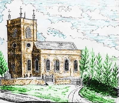
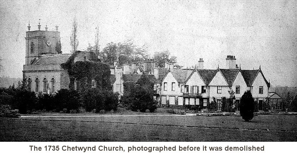
| Description | : | The grave yard is located on private property in the grounds of the current Chetwynd Manor House. South of the house is the site of Chetwynd old church, rebuilt in 1775 and demolished in the mid 1860s. Some gravestones still survive in the former churchyard. The gardens at Chetwynd were newly laid out in the 1860s when the house was rebuilt, extending over the site of the church, graveyard and Rectory. From the 1400’s to the later 1700’s Chetwynd was held by the Pigotts. The last of them, Robert Pigott, sheriff of Shropshire in 1774, sold the... Read More |
frequently asked questions (FAQ):
-
Where is Chetwynd Churchyard?
Chetwynd Churchyard is located at TF10 8AE Newport, Telford and Wrekin Unitary Authority ,Shropshire ,England.
-
Chetwynd Churchyard cemetery's updated grave count on graveviews.com?
0 memorials
-
Where are the coordinates of the Chetwynd Churchyard?
Latitude: 52.7905280
Longitude: -2.3916390
Nearby Cemetories:
1. Saint Michael and All Angels
Chetwynd, Telford and Wrekin Unitary Authority, England
Coordinate: 52.7887300, -2.3935160
2. Forton All Saints Churchyard
Newport, Telford and Wrekin Unitary Authority, England
Coordinate: 52.7876210, -2.3640430
3. St. Nicholas Churchyard
Newport, Telford and Wrekin Unitary Authority, England
Coordinate: 52.7696720, -2.3793420
4. St. Peter Church
Edgmond, Telford and Wrekin Unitary Authority, England
Coordinate: 52.7699680, -2.4159730
5. Newport General Cemetery
Newport, Telford and Wrekin Unitary Authority, England
Coordinate: 52.7656260, -2.3655840
6. Talbot Chapel
Longford, Telford and Wrekin Unitary Authority, England
Coordinate: 52.7627400, -2.4081500
7. St Andrews Churchyard
Church Aston, Telford and Wrekin Unitary Authority, England
Coordinate: 52.7577930, -2.3815770
8. Church of St Peter
Norbury, Stafford Borough, England
Coordinate: 52.8084000, -2.3184000
9. Tibberton All Saints
Tibberton, Telford and Wrekin Unitary Authority, England
Coordinate: 52.7800660, -2.4741020
10. St Michael and All Angels Churchyard
Lilleshall, Telford and Wrekin Unitary Authority, England
Coordinate: 52.7345610, -2.4032770
11. St Oswald's Church Burial Ground
Hinstock, Shropshire Unitary Authority, England
Coordinate: 52.8346100, -2.4577700
12. Woodcote Parish Church
Woodcote, Telford and Wrekin Unitary Authority, England
Coordinate: 52.7358330, -2.3456640
13. St Michael and All Angels Churchyard
Adbaston, Stafford Borough, England
Coordinate: 52.8482630, -2.3545010
14. Lilleshall Abbey
Lilleshall, Telford and Wrekin Unitary Authority, England
Coordinate: 52.7247000, -2.3898000
15. St Mary's, Moreton
Moreton, Stafford Borough, England
Coordinate: 52.7521490, -2.3021420
16. St Michael & All Angels
Childs Ercall, Shropshire Unitary Authority, England
Coordinate: 52.8222524, -2.4975524
17. St. Swithun's Churchyard
Cheswardine, Shropshire Unitary Authority, England
Coordinate: 52.8660400, -2.4187700
18. St. Matthew's Churchyard
Donnington Wood, Telford and Wrekin Unitary Authority, England
Coordinate: 52.7148135, -2.4308853
19. St. Lawrence Churchyard
Gnosall, Stafford Borough, England
Coordinate: 52.7853010, -2.2533270
20. Holy Trinity Church
Wrockwardine, Telford and Wrekin Unitary Authority, England
Coordinate: 52.7105800, -2.4476600
21. Wrockwardine Wood Methodist Graveyard
Wrockwardine, Telford and Wrekin Unitary Authority, England
Coordinate: 52.7076180, -2.4426530
22. St Michael Churchyard
Waters Upton, Telford and Wrekin Unitary Authority, England
Coordinate: 52.7713210, -2.5439270
23. Ronton Priory
Ellenhall, Stafford Borough, England
Coordinate: 52.8157600, -2.2414900
24. Telford Crematorium
Redhill, Telford and Wrekin Unitary Authority, England
Coordinate: 52.6950750, -2.3988090