
| Memorials | : | 0 |
| Location | : | Catthorpe, Harborough District, England |
| Phone | : | 01858 882032 |
| Website | : | www.avonswift.co.uk/ |
| Coordinate | : | 52.3986350, -1.1900710 |
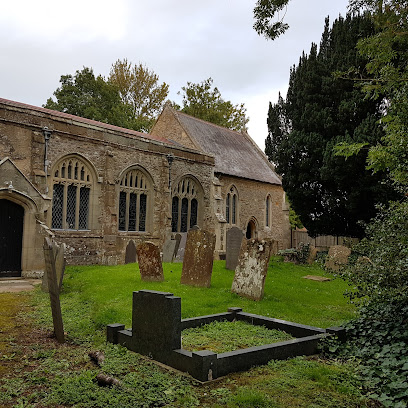
| Description | : | Home Parish Council Places News Events Planning Businesses Photos Contact The church of St. Thomas is a small building of stone erected about the end of the 13th or beginning of the 14th century, and is chiefly in the Early English and Decorated styles, with some portions of Perpendicular date, and consists of chancel, nave, south porch and a low embattled western tower containing 3 bells, two dated 1350 and one dated 1770: the organ was presented by J. P. Cross esq. of Catthorpe Towers in 1886; in 1897 a memorial window was placed in the south side to the Cross family and another in 1908 to J. P.... Read More |
frequently asked questions (FAQ):
-
Where is St. Thomas Churchyard, Catthorpe?
St. Thomas Churchyard, Catthorpe is located at Main Street Catthorpe, Harborough District ,Leicestershire , LE17 6DBEngland.
-
St. Thomas Churchyard, Catthorpe cemetery's updated grave count on graveviews.com?
0 memorials
-
Where are the coordinates of the St. Thomas Churchyard, Catthorpe?
Latitude: 52.3986350
Longitude: -1.1900710
Nearby Cemetories:
1. All Saints Churchyard
Lilbourne, Daventry District, England
Coordinate: 52.3919370, -1.1778810
2. Lilbourne Burial Ground
Lilbourne, Daventry District, England
Coordinate: 52.3885400, -1.1792400
3. Swinford cemetery
Swinford, Harborough District, England
Coordinate: 52.4088297, -1.1695096
4. All Saints Churchyard
Shawell, Harborough District, England
Coordinate: 52.4123910, -1.2055290
5. All Saints Churchyard
Swinford, Harborough District, England
Coordinate: 52.4099260, -1.1642830
6. Clifton-Upon-Dunsmore Cemetery
Clifton upon Dunsmore, Rugby Borough, England
Coordinate: 52.3857800, -1.2197400
7. Greenhaven Woodland Burial Ground
Lilbourne, Daventry District, England
Coordinate: 52.3881390, -1.1545970
8. St. Mary's Churchyard
Clifton upon Dunsmore, Rugby Borough, England
Coordinate: 52.3830220, -1.2208600
9. St Nicholas' Churchyard
Stanford on Avon, Harborough District, England
Coordinate: 52.4045560, -1.1362100
10. St. Nicholas's Churchyard
Stanford-on-Avon, Daventry District, England
Coordinate: 52.4045020, -1.1359770
11. St. John's Baptist Churchyard
Hillmorton, Rugby Borough, England
Coordinate: 52.3659310, -1.2113290
12. Whinfield Cemetery
Rugby, Rugby Borough, England
Coordinate: 52.3718560, -1.2353290
13. St. Andrew's Churchyard
Clay Coton, Daventry District, England
Coordinate: 52.3871456, -1.1290185
14. St. Michael & All Angels Churchyard
Rugby Borough, England
Coordinate: 52.3920240, -1.2540180
15. St Mary's Churchyard
Cotesbach, Harborough District, England
Coordinate: 52.4371220, -1.2085910
16. Watts Lane Cemetery
Rugby, Rugby Borough, England
Coordinate: 52.3592560, -1.2133530
17. Holy Trinity Churchyard
Churchover, Rugby Borough, England
Coordinate: 52.4229460, -1.2506850
18. Clifton Road Cemetery
Rugby, Rugby Borough, England
Coordinate: 52.3722330, -1.2483020
19. Yelvertoft Independent Chapel Churchyard
Yelvertoft, Daventry District, England
Coordinate: 52.3736980, -1.1225680
20. St. Andrew's Churchyard
Rugby, Rugby Borough, England
Coordinate: 52.3726220, -1.2612630
21. All Saints Churchyard
Yelvertoft, Daventry District, England
Coordinate: 52.3717866, -1.1164310
22. St Leonard Churchyard
Misterton, Harborough District, England
Coordinate: 52.4510630, -1.1818140
23. Rugby School Chapel
Rugby, Rugby Borough, England
Coordinate: 52.3703890, -1.2639150
24. Yelvertoft Cemetery
Yelvertoft, Daventry District, England
Coordinate: 52.3707000, -1.1153400