
| Memorials | : | 0 |
| Location | : | Swinford, Harborough District, England |
| Coordinate | : | 52.4099260, -1.1642830 |
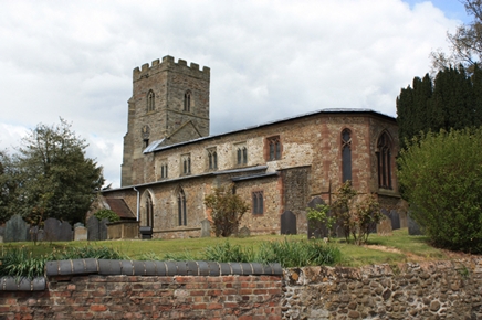
| Description | : | Grade II listed bulding, a 12th-century Norman rebuilding of an earlier Saxon church, with a 14th-century square bell tower. |
frequently asked questions (FAQ):
-
Where is All Saints Churchyard?
All Saints Churchyard is located at Church Walk Swinford, Harborough District ,Leicestershire , LE17 6AYEngland.
-
All Saints Churchyard cemetery's updated grave count on graveviews.com?
0 memorials
-
Where are the coordinates of the All Saints Churchyard?
Latitude: 52.4099260
Longitude: -1.1642830
Nearby Cemetories:
1. Swinford cemetery
Swinford, Harborough District, England
Coordinate: 52.4088297, -1.1695096
2. St Nicholas' Churchyard
Stanford on Avon, Harborough District, England
Coordinate: 52.4045560, -1.1362100
3. St. Nicholas's Churchyard
Stanford-on-Avon, Daventry District, England
Coordinate: 52.4045020, -1.1359770
4. St. Thomas Churchyard, Catthorpe
Catthorpe, Harborough District, England
Coordinate: 52.3986350, -1.1900710
5. All Saints Churchyard
Lilbourne, Daventry District, England
Coordinate: 52.3919370, -1.1778810
6. Greenhaven Woodland Burial Ground
Lilbourne, Daventry District, England
Coordinate: 52.3881390, -1.1545970
7. Lilbourne Burial Ground
Lilbourne, Daventry District, England
Coordinate: 52.3885400, -1.1792400
8. All Saints Churchyard
Shawell, Harborough District, England
Coordinate: 52.4123910, -1.2055290
9. St. Andrew's Churchyard
Clay Coton, Daventry District, England
Coordinate: 52.3871456, -1.1290185
10. St Mary's Churchyard
Cotesbach, Harborough District, England
Coordinate: 52.4371220, -1.2085910
11. St Nicholas Church
South Kilworth, Harborough District, England
Coordinate: 52.4316750, -1.1125110
12. Clifton-Upon-Dunsmore Cemetery
Clifton upon Dunsmore, Rugby Borough, England
Coordinate: 52.3857800, -1.2197400
13. St Leonard Churchyard
Misterton, Harborough District, England
Coordinate: 52.4510630, -1.1818140
14. St. Mary's Churchyard
Clifton upon Dunsmore, Rugby Borough, England
Coordinate: 52.3830220, -1.2208600
15. Yelvertoft Independent Chapel Churchyard
Yelvertoft, Daventry District, England
Coordinate: 52.3736980, -1.1225680
16. All Saints Churchyard
Yelvertoft, Daventry District, England
Coordinate: 52.3717866, -1.1164310
17. Yelvertoft Cemetery
Yelvertoft, Daventry District, England
Coordinate: 52.3707000, -1.1153400
18. Saint Mary's Churchyard
Lutterworth, Harborough District, England
Coordinate: 52.4554750, -1.2023830
19. St. John's Baptist Churchyard
Hillmorton, Rugby Borough, England
Coordinate: 52.3659310, -1.2113290
20. St. Andrew Churchyard
North Kilworth, Harborough District, England
Coordinate: 52.4432190, -1.0950880
21. Holy Trinity Churchyard
Churchover, Rugby Borough, England
Coordinate: 52.4229460, -1.2506850
22. St. Michael & All Angels Churchyard
Rugby Borough, England
Coordinate: 52.3920240, -1.2540180
23. Whinfield Cemetery
Rugby, Rugby Borough, England
Coordinate: 52.3718560, -1.2353290
24. Watts Lane Cemetery
Rugby, Rugby Borough, England
Coordinate: 52.3592560, -1.2133530