
| Memorials | : | 10 |
| Location | : | Bean Station, Grainger County, USA |
| Coordinate | : | 36.2876670, -83.2907330 |
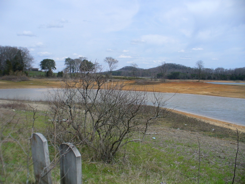
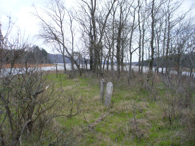
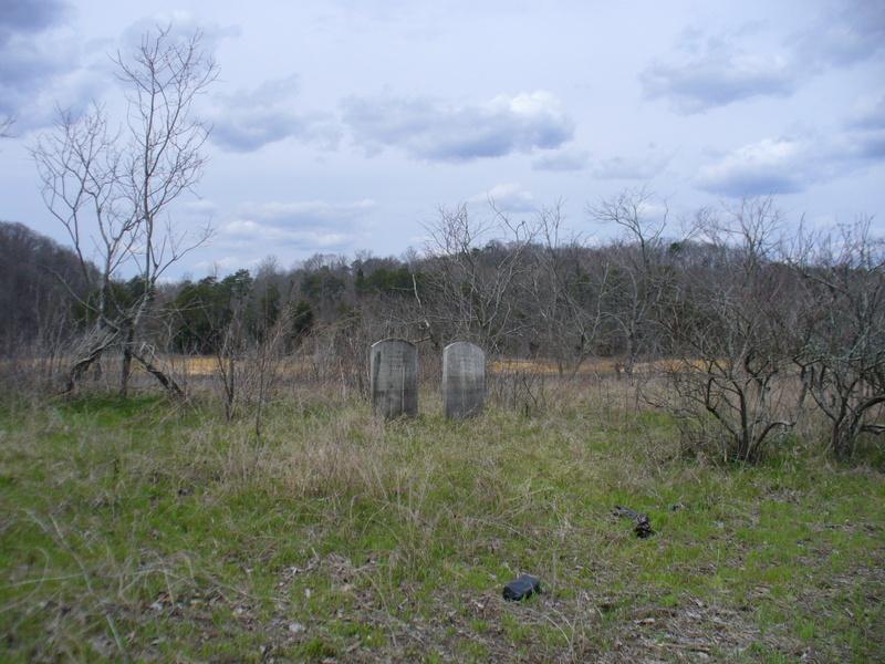
| Description | : | Identified by TVA as Taylor Private Cemetery #2, Taylor Family Cemetery was flooded by the impoundment of the waters of Cherokee Lake in 1941. TVA's survey determined that the cemetery held 38 graves, but only fifteen were identified. Of these, eight graves were reinterred in other cemeteries. Relatives of those buried in the remaining seven identified graves authorized TVA to leave them in place. The remaining unidentified graves were also left undisturbed. Taylor Family Cemetery is visible at low water, but only two markers were found in 2013. |
frequently asked questions (FAQ):
-
Where is Taylor Family Cemetery?
Taylor Family Cemetery is located at Bean Station, Grainger County ,Tennessee ,USA.
-
Taylor Family Cemetery cemetery's updated grave count on graveviews.com?
10 memorials
-
Where are the coordinates of the Taylor Family Cemetery?
Latitude: 36.2876670
Longitude: -83.2907330
Nearby Cemetories:
1. Grantham Cemetery
Grainger County, USA
Coordinate: 36.2946860, -83.2794570
2. Dodson Cemetery
Bean Station, Grainger County, USA
Coordinate: 36.2989006, -83.2869034
3. Livingston Cemetery
Bean Station, Grainger County, USA
Coordinate: 36.2785988, -83.2791977
4. Ford Cemetery
Grainger County, USA
Coordinate: 36.2902985, -83.3071976
5. Rocky Summit Cemetery
Bean Station, Grainger County, USA
Coordinate: 36.2984750, -83.2799030
6. N L Henard Cemetery
Morristown, Hamblen County, USA
Coordinate: 36.2708221, -83.2726048
7. Samsel Cemetery
Bean Station, Grainger County, USA
Coordinate: 36.3114014, -83.2925034
8. Adriel Baptist Church Cemetery
Bean Station, Grainger County, USA
Coordinate: 36.3125000, -83.2897034
9. First Independent Freewill Baptist Church Cemetery
Bean Station, Grainger County, USA
Coordinate: 36.3158860, -83.2855850
10. Meek Cemetery
Bean Station, Grainger County, USA
Coordinate: 36.3207180, -83.2797150
11. County Line Cemetery
Bean Station, Grainger County, USA
Coordinate: 36.3207700, -83.2789850
12. Macedonia Missionary Baptist Church Cemetery
Morristown, Hamblen County, USA
Coordinate: 36.2696100, -83.3301400
13. Harris Cemetery
Grainger County, USA
Coordinate: 36.3055992, -83.3308029
14. Noeton Baptist Church Cemetery Original
Bean Station, Grainger County, USA
Coordinate: 36.3012600, -83.3342200
15. Winstead Family Cemetery
Hamblen County, USA
Coordinate: 36.2493060, -83.3161570
16. DeBord Cemetery
Bean Station, Grainger County, USA
Coordinate: 36.3315000, -83.2834000
17. Harrell Cemetery
Bean Station, Grainger County, USA
Coordinate: 36.3074989, -83.3463974
18. Noes Chapel United Methodist Church Cemetery
Morristown, Hamblen County, USA
Coordinate: 36.2401000, -83.3124900
19. Fairfield Baptist Church Cemetery
Hamblen County, USA
Coordinate: 36.2561000, -83.2401800
20. Amis Cemetery
Hamblen County, USA
Coordinate: 36.2898100, -83.2255000
21. Cedar Creek Cemetery
Russellville, Hamblen County, USA
Coordinate: 36.2711360, -83.2274010
22. Marys Chapel Cemetery
Grainger County, USA
Coordinate: 36.3011017, -83.3569031
23. Little Redeemed Church Cemetery
Hamblen County, USA
Coordinate: 36.2421700, -83.3291200
24. Liberty Hill Methodist Church Cemetery
Hamblen County, USA
Coordinate: 36.2340300, -83.2751600