
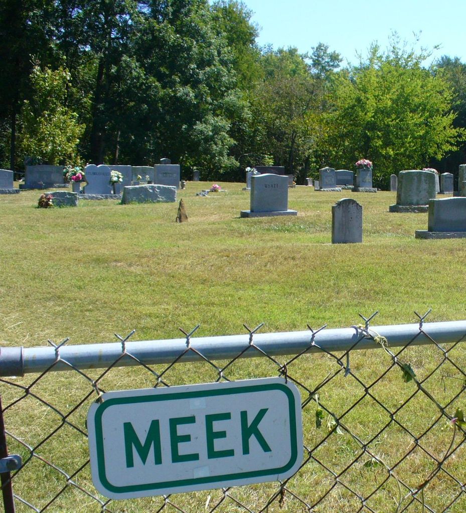
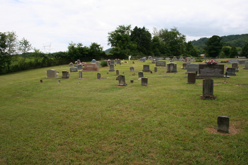
| Memorials | : | 66 |
| Location | : | Bean Station, Grainger County, USA |
| Coordinate | : | 36.3207180, -83.2797150 |
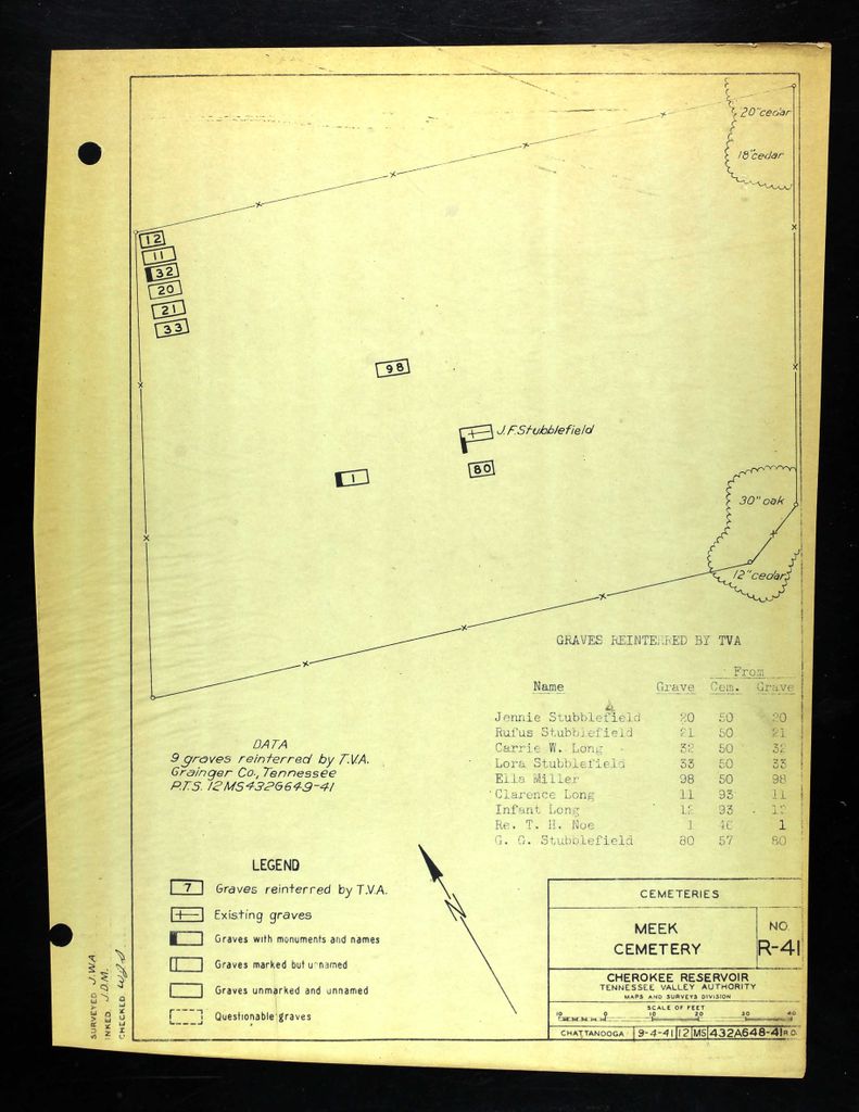
| Description | : | On land originally owned by Hughes Owen Taylor, which was acquired upon his death in 1852 by his daughter, Alice Elizabeth Taylor Meek, Meek Cemetery began in the 1870's as the Meek family burying ground, adjoining the older County Line Cemetery. Around the turn of the century, more burials in the County Line community began occurring in the newer Meek Cemetery, and neighboring County Line Cemetery became abandoned. When the Meek family sold the property, the 1940 deed stipulated that the cemetery remain available as a burying ground for the community. TVA reinterred nine graves here during the creation of... Read More |
frequently asked questions (FAQ):
-
Where is Meek Cemetery?
Meek Cemetery is located at Wyatt Village Road Bean Station, Grainger County ,Tennessee ,USA.
-
Meek Cemetery cemetery's updated grave count on graveviews.com?
66 memorials
-
Where are the coordinates of the Meek Cemetery?
Latitude: 36.3207180
Longitude: -83.2797150
Nearby Cemetories:
1. County Line Cemetery
Bean Station, Grainger County, USA
Coordinate: 36.3207700, -83.2789850
2. First Independent Freewill Baptist Church Cemetery
Bean Station, Grainger County, USA
Coordinate: 36.3158860, -83.2855850
3. DeBord Cemetery
Bean Station, Grainger County, USA
Coordinate: 36.3315000, -83.2834000
4. Adriel Baptist Church Cemetery
Bean Station, Grainger County, USA
Coordinate: 36.3125000, -83.2897034
5. Samsel Cemetery
Bean Station, Grainger County, USA
Coordinate: 36.3114014, -83.2925034
6. Central United Methodist Church Cemetery
Bean Station, Grainger County, USA
Coordinate: 36.3422740, -83.2798470
7. Rocky Summit Cemetery
Bean Station, Grainger County, USA
Coordinate: 36.2984750, -83.2799030
8. Dodson Cemetery
Bean Station, Grainger County, USA
Coordinate: 36.2989006, -83.2869034
9. Grantham Cemetery
Grainger County, USA
Coordinate: 36.2946860, -83.2794570
10. Moores Chapel Cemetery
Bean Station, Grainger County, USA
Coordinate: 36.3488998, -83.2897034
11. Garrett Cemetery
Grainger County, USA
Coordinate: 36.3414001, -83.3082962
12. Taylor Family Cemetery
Bean Station, Grainger County, USA
Coordinate: 36.2876670, -83.2907330
13. Meadow Branch Cemetery
Bean Station, Grainger County, USA
Coordinate: 36.3572006, -83.2822037
14. Samsel Cemetery
Bean Station, Grainger County, USA
Coordinate: 36.3424020, -83.3167060
15. Ford Cemetery
Grainger County, USA
Coordinate: 36.2902985, -83.3071976
16. Samsel Lakeview Cemetery
Bean Station, Grainger County, USA
Coordinate: 36.3475800, -83.3189468
17. Livingston Cemetery
Bean Station, Grainger County, USA
Coordinate: 36.2785988, -83.2791977
18. Holt Cemetery #2
Bean Station, Grainger County, USA
Coordinate: 36.3630560, -83.2844440
19. Harris Cemetery
Grainger County, USA
Coordinate: 36.3055992, -83.3308029
20. Dalton Cemetery
Bean Station, Grainger County, USA
Coordinate: 36.3428001, -83.3296967
21. Noeton Baptist Church Cemetery Original
Bean Station, Grainger County, USA
Coordinate: 36.3012600, -83.3342200
22. N L Henard Cemetery
Morristown, Hamblen County, USA
Coordinate: 36.2708221, -83.2726048
23. Amis Cemetery
Hamblen County, USA
Coordinate: 36.2898100, -83.2255000
24. Harrell Cemetery
Bean Station, Grainger County, USA
Coordinate: 36.3074989, -83.3463974