
| Memorials | : | 0 |
| Location | : | Throop, Bournemouth Unitary Authority, England |
| Coordinate | : | 50.7630100, -1.8497100 |
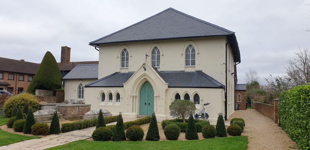
| Description | : | Throop is a village in Dorset situated on the outskirts of Bournemouth.Although within the historic county boundaries of Hampshire, at the time of the 1974 local government re-organization it was considered desirable that the whole of what is now called the South East Dorset conurbation, which includes Bournemouth and Poole, should be part of the same county. There are four wargraves here. |
frequently asked questions (FAQ):
-
Where is Throop United Reform Churchyard?
Throop United Reform Churchyard is located at Muscliffe Lane Throop, Bournemouth Unitary Authority ,Dorset , BH8 0AEEngland.
-
Throop United Reform Churchyard cemetery's updated grave count on graveviews.com?
0 memorials
-
Where are the coordinates of the Throop United Reform Churchyard?
Latitude: 50.7630100
Longitude: -1.8497100
Nearby Cemetories:
1. Throop Jewish Cemetery
Bournemouth, Bournemouth Unitary Authority, England
Coordinate: 50.7600190, -1.8504310
2. Bournemouth Crematorium and North Cemetery
Bournemouth, Bournemouth Unitary Authority, England
Coordinate: 50.7455406, -1.8576280
3. All Saints Churchyard
West Parley, East Dorset District, England
Coordinate: 50.7710152, -1.8783700
4. St John the Evangelist Churchyard
Bournemouth Unitary Authority, England
Coordinate: 50.7564980, -1.8191740
5. St John the Baptist Churchyard
Bournemouth, Bournemouth Unitary Authority, England
Coordinate: 50.7500600, -1.8778700
6. East Howe United Reformed Church Cemetery
Bournemouth, Bournemouth Unitary Authority, England
Coordinate: 50.7590790, -1.8996290
7. East Cemetery
Bournemouth, Bournemouth Unitary Authority, England
Coordinate: 50.7318590, -1.8348290
8. Kinson Cemetery
Bournemouth, Bournemouth Unitary Authority, England
Coordinate: 50.7612600, -1.9030400
9. St Clement's Churchyard
Boscombe, Bournemouth Unitary Authority, England
Coordinate: 50.7287580, -1.8496680
10. Wimborne Road Cemetery
Bournemouth, Bournemouth Unitary Authority, England
Coordinate: 50.7323220, -1.8739990
11. St James Churchyard
Bournemouth Unitary Authority, England
Coordinate: 50.7325437, -1.8208692
12. St. Andrew's Churchyard
Kinson, Bournemouth Unitary Authority, England
Coordinate: 50.7718700, -1.9049920
13. Pokesdown Congregational Church
Southbourne, Bournemouth Unitary Authority, England
Coordinate: 50.7308910, -1.8197670
14. St. Mark's Churchyard
Bournemouth Unitary Authority, England
Coordinate: 50.7464670, -1.9026870
15. Christchurch Cemetery
Christchurch, Christchurch Borough, England
Coordinate: 50.7427800, -1.7940900
16. Sopley Cemetery
Sopley, New Forest District, England
Coordinate: 50.7774250, -1.7847770
17. St Michael and All Angels Churchyard
Sopley, New Forest District, England
Coordinate: 50.7697400, -1.7794200
18. St Peter Churchyard
Bournemouth, Bournemouth Unitary Authority, England
Coordinate: 50.7205020, -1.8755870
19. St Mary Churchyard
Ferndown, East Dorset District, England
Coordinate: 50.7997260, -1.8935890
20. All Saints Churchyard
Hampreston, East Dorset District, England
Coordinate: 50.7887250, -1.9231050
21. Christchurch Congregational Church Graveyards
Christchurch, Christchurch Borough, England
Coordinate: 50.7347966, -1.7762867
22. St Luke's Churchyard
Burton, Christchurch Borough, England
Coordinate: 50.7532240, -1.7650090
23. West Moors Cemetery
West Moors, East Dorset District, England
Coordinate: 50.8158410, -1.8737500
24. St Ambrose Church
Bournemouth Unitary Authority, England
Coordinate: 50.7176530, -1.9004020