
| Memorials | : | 0 |
| Location | : | Nunspeet Municipality, Netherlands |
| Website | : | www.verscholendorpvierhouten.nl/ |
| Coordinate | : | 52.3363600, 5.8721700 |
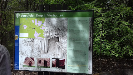
| Description | : | World War II hiding place in the south of Nunspeet, between the village and Vierhouten. The camp was established in February 1943 in the Soerelse Bossen near Vierhouten. The camp consisted of four sections of nine semi-above ground huts. It was inhabited by refugees from the transit camp in Amersfoort, young men from the labor force, Jewish families and stranded pilots. For some time there was also a German who had deserted from the German army. On average, there were 80 to 100 people in hiding per day. On 29 October 1944 the village was discovered by two SS... Read More |
frequently asked questions (FAQ):
-
Where is Verscholen Dorp Hidden Village Memorial?
Verscholen Dorp Hidden Village Memorial is located at Pas-Opweg Nunspeet Municipality ,Gelderland , 8166HNNetherlands.
-
Verscholen Dorp Hidden Village Memorial cemetery's updated grave count on graveviews.com?
0 memorials
-
Where are the coordinates of the Verscholen Dorp Hidden Village Memorial?
Latitude: 52.3363600
Longitude: 5.8721700
Nearby Cemetories:
1. Nunspeet New General Cemetery
Nunspeet, Nunspeet Municipality, Netherlands
Coordinate: 52.3789600, 5.7984700
2. Epe General Cemetery
Epe, Epe Municipality, Netherlands
Coordinate: 52.3473700, 5.9743200
3. Begraafplaats Elspeet
Elspeet, Nunspeet Municipality, Netherlands
Coordinate: 52.2844300, 5.7867800
4. Vaassen General Cemetery
Vaassen, Epe Municipality, Netherlands
Coordinate: 52.2823600, 5.9654300
5. Begraafplaats Wenum-Wiesel
Wenum, Apeldoorn Municipality, Netherlands
Coordinate: 52.2657500, 5.9608700
6. Begraafplaats Uddel
Uddel, Apeldoorn Municipality, Netherlands
Coordinate: 52.2614100, 5.7895700
7. Heerde Begraafplaats Engelmanskamp
Heerde, Heerde Municipality, Netherlands
Coordinate: 52.3890900, 6.0060200
8. Begraafplaats Burchtstraat
Elburg, Elburg Municipality, Netherlands
Coordinate: 52.4417190, 5.8324400
9. Heerde Old General Cemetery
Heerde, Heerde Municipality, Netherlands
Coordinate: 52.3908300, 6.0354900
10. De Eekelenburg
Oldebroek, Oldebroek Municipality, Netherlands
Coordinate: 52.4472600, 5.9157800
11. Joodse Begraafplaats
Elburg, Elburg Municipality, Netherlands
Coordinate: 52.4486337, 5.8378073
12. Begraafplaats Soerenseweg
Apeldoorn, Apeldoorn Municipality, Netherlands
Coordinate: 52.2194500, 5.9395700
13. Oosterwolde General Cemetery
Oosterwolde, Oldebroek Municipality, Netherlands
Coordinate: 52.4604800, 5.8851900
14. Nijbroek Algemene Begraafplaats
Nijbroek, Voorst Municipality, Netherlands
Coordinate: 52.2820600, 6.0598800
15. St. Antonius RK Kerkhof
De Vecht, Voorst Municipality, Netherlands
Coordinate: 52.2582100, 6.0363300
16. Apeldoorn Arnhemseweg Catholic Cemetery
Apeldoorn, Apeldoorn Municipality, Netherlands
Coordinate: 52.2062100, 5.9624700
17. Natuurbegraafplaats Westerwolde
Assel, Apeldoorn Municipality, Netherlands
Coordinate: 52.1949200, 5.8427200
18. Harderwijk General Cemetery
Harderwijk, Harderwijk Municipality, Netherlands
Coordinate: 52.3499300, 5.6374200
19. Duur General Cemetery
Duur, Olst-Wijhe Municipality, Netherlands
Coordinate: 52.3577300, 6.1107300
20. Joodse Begraafplaats
Den Nul, Olst-Wijhe Municipality, Netherlands
Coordinate: 52.3590800, 6.1122400
21. Joodse Begraafplaats Beth Chaim
Harderwijk Municipality, Netherlands
Coordinate: 52.3330300, 5.6279200
22. Apeldoorn Joodse Begraafplaats
Apeldoorn, Apeldoorn Municipality, Netherlands
Coordinate: 52.1970310, 5.9617940
23. Begraafplaats Heidehof
Ugchelen, Apeldoorn Municipality, Netherlands
Coordinate: 52.1777800, 5.9326800
24. Terwolde General Cemetery
Terwolde, Voorst Municipality, Netherlands
Coordinate: 52.2589300, 6.1102400