| Memorials | : | 0 |
| Location | : | Shelf, Metropolitan Borough of Calderdale, England |
| Coordinate | : | 53.7543871, -1.8140742 |
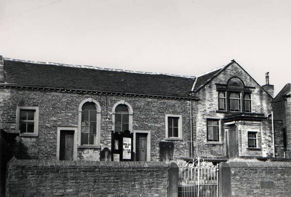
| Description | : | Wade House Primitive Methodist Church, Shelf Primitive Methodist missionaries came to Shelf in 1821 and we are told that they walked around the village singing hymns. The Chapel was built between 1822 and 1823 although the building “was blown down once or twice during the course of its erection.” The building was extended at one end in 1854 and 1866 to form a Sunday school which was rebuilt in 1901. The Chapel closed in October 1973 shortly after celebrating their 151st Anniversary, having “lost heavily by removal, by deaths and were left with a few aged people, half of whom were... Read More |
frequently asked questions (FAQ):
-
Where is Wade House Primitive Methodist Church?
Wade House Primitive Methodist Church is located at Wade House Road Shelf, Metropolitan Borough of Calderdale ,West Yorkshire ,England.
-
Wade House Primitive Methodist Church cemetery's updated grave count on graveviews.com?
0 memorials
-
Where are the coordinates of the Wade House Primitive Methodist Church?
Latitude: 53.7543871
Longitude: -1.8140742
Nearby Cemetories:
1. Witchfield Wesleyan Methodist Church
Shelf, Metropolitan Borough of Calderdale, England
Coordinate: 53.7559447, -1.8114241
2. Bethel Methodist Chapelyard
Shelf, Metropolitan Borough of Calderdale, England
Coordinate: 53.7563530, -1.8079900
3. Pollard Family Burial Ground
Shelf, Metropolitan Borough of Calderdale, England
Coordinate: 53.7570244, -1.8072409
4. St. Michael & All Angels Churchyard
Shelf, Metropolitan Borough of Calderdale, England
Coordinate: 53.7573400, -1.8030500
5. St John the Baptist Churchyard
Coley, Metropolitan Borough of Calderdale, England
Coordinate: 53.7385570, -1.8119940
6. Clayton Heights Methodist Chapelyard
Bradford, Metropolitan Borough of Bradford, England
Coordinate: 53.7705400, -1.8227400
7. Heywood United Reformed Chapelyard
Northowram, Metropolitan Borough of Calderdale, England
Coordinate: 53.7369550, -1.8325630
8. North Bierley Municipal Cemetery
Bradford, Metropolitan Borough of Bradford, England
Coordinate: 53.7584470, -1.7781560
9. St. Paul Churchyard
Wibsey, Metropolitan Borough of Bradford, England
Coordinate: 53.7636700, -1.7784700
10. Queensbury Cemetery
Queensbury, Metropolitan Borough of Bradford, England
Coordinate: 53.7666270, -1.8478510
11. Holy Trinity Churchyard
Queensbury, Metropolitan Borough of Bradford, England
Coordinate: 53.7670300, -1.8485400
12. Queensbury Baptist Church
Queensbury, Metropolitan Borough of Bradford, England
Coordinate: 53.7690533, -1.8469805
13. St Mark Churchyard
Low Moor, Metropolitan Borough of Bradford, England
Coordinate: 53.7512500, -1.7696100
14. Ambler Thorn United Methodist Burial Ground
Queensbury, Metropolitan Borough of Bradford, England
Coordinate: 53.7601200, -1.8590700
15. Clayton Methodist Chapelyard
Clayton, Metropolitan Borough of Bradford, England
Coordinate: 53.7812800, -1.8232500
16. Wibsey Salvation Army Memorial Garden
Wibsey, Metropolitan Borough of Bradford, England
Coordinate: 53.7664200, -1.7702900
17. Clayton Baptist Churchyard
Clayton, Metropolitan Borough of Bradford, England
Coordinate: 53.7830600, -1.8192200
18. Zion Congregationalist Church Graveyard
Bradford, Metropolitan Borough of Bradford, England
Coordinate: 53.7681900, -1.7702550
19. St John the Baptist Churchyard
Clayton, Metropolitan Borough of Bradford, England
Coordinate: 53.7836900, -1.8210500
20. St. Mary the Virgin Churchyard
Wyke, Metropolitan Borough of Bradford, England
Coordinate: 53.7363400, -1.7715600
21. Great Horton Methodist Churchyard
Bradford, Metropolitan Borough of Bradford, England
Coordinate: 53.7813052, -1.7849559
22. Holy Trinity Churchyard
Low Moor, Metropolitan Borough of Bradford, England
Coordinate: 53.7564900, -1.7590000
23. St. Matthew Churchyard
Bradford, Metropolitan Borough of Bradford, England
Coordinate: 53.7689950, -1.7638640
24. St. Matthew's Old Churchyard
Lightcliffe, Metropolitan Borough of Calderdale, England
Coordinate: 53.7245690, -1.7894920

