
| Memorials | : | 0 |
| Location | : | Low Moor, Metropolitan Borough of Bradford, England |
| Coordinate | : | 53.7564900, -1.7590000 |
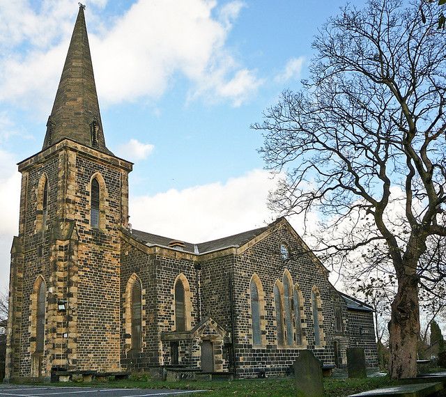
| Description | : | The first church was built 1606 as a Chapel of Ease to St Peter's in the Parish of Bradford. For much of its earlier life it was known as "Wibsey Chapel" despite the fact that it is some distance from the village of Wibsey. The site chosen is roughly equidistant from Royds Hall, the home of the Rookes, and Bierley Hall, the home of the Richardsons – local gentry families. The church was consecrated to the Holy Trinity in 1636 and a small graveyard added The church was enlarged and practically rebuilt by moving the walls further out and adding the... Read More |
frequently asked questions (FAQ):
-
Where is Holy Trinity Churchyard?
Holy Trinity Churchyard is located at Park House Road Low Moor, Metropolitan Borough of Bradford ,West Yorkshire , BD12 0HREngland.
-
Holy Trinity Churchyard cemetery's updated grave count on graveviews.com?
0 memorials
-
Where are the coordinates of the Holy Trinity Churchyard?
Latitude: 53.7564900
Longitude: -1.7590000
Nearby Cemetories:
1. Wesley Place Methodist Chapelyard
Low Moor, Metropolitan Borough of Bradford, England
Coordinate: 53.7528600, -1.7573100
2. St Mark Churchyard
Low Moor, Metropolitan Borough of Bradford, England
Coordinate: 53.7512500, -1.7696100
3. North Bierley Municipal Cemetery
Bradford, Metropolitan Borough of Bradford, England
Coordinate: 53.7584470, -1.7781560
4. Wibsey Salvation Army Memorial Garden
Wibsey, Metropolitan Borough of Bradford, England
Coordinate: 53.7664200, -1.7702900
5. St. Matthew Churchyard
Bradford, Metropolitan Borough of Bradford, England
Coordinate: 53.7689950, -1.7638640
6. Zion Congregationalist Church Graveyard
Bradford, Metropolitan Borough of Bradford, England
Coordinate: 53.7681900, -1.7702550
7. St. Paul Churchyard
Wibsey, Metropolitan Borough of Bradford, England
Coordinate: 53.7636700, -1.7784700
8. Bowling Cemetery
West Bowling, Metropolitan Borough of Bradford, England
Coordinate: 53.7714844, -1.7370390
9. Westfield United Reform Chapel
Wyke, Metropolitan Borough of Bradford, England
Coordinate: 53.7355456, -1.7629691
10. St. John the Evangelist Churchyard
Bradford, Metropolitan Borough of Bradford, England
Coordinate: 53.7705297, -1.7323057
11. St. Mary the Virgin Churchyard
Wyke, Metropolitan Borough of Bradford, England
Coordinate: 53.7363400, -1.7715600
12. St Stephen Churchyard
West Bowling, Metropolitan Borough of Bradford, England
Coordinate: 53.7783440, -1.7578570
13. Friends Burial Ground
Bradford, Metropolitan Borough of Bradford, England
Coordinate: 53.7788470, -1.7747890
14. St. Michael & All Angels Churchyard
Shelf, Metropolitan Borough of Calderdale, England
Coordinate: 53.7573400, -1.8030500
15. St Philip and St James Church Memorial Garden
Cleckheaton, Metropolitan Borough of Kirklees, England
Coordinate: 53.7291800, -1.7481500
16. Lower Wyke Moravian Churchyard
Wyke, Metropolitan Borough of Bradford, England
Coordinate: 53.7295640, -1.7735920
17. Pollard Family Burial Ground
Shelf, Metropolitan Borough of Calderdale, England
Coordinate: 53.7570244, -1.8072409
18. Cleckheaton New Cemetery
Cleckheaton, Metropolitan Borough of Kirklees, England
Coordinate: 53.7298910, -1.7400120
19. Bethel Methodist Chapelyard
Shelf, Metropolitan Borough of Calderdale, England
Coordinate: 53.7563530, -1.8079900
20. Great Horton Methodist Churchyard
Bradford, Metropolitan Borough of Bradford, England
Coordinate: 53.7813052, -1.7849559
21. St. John's Church, Bowling
Bradford, Metropolitan Borough of Bradford, England
Coordinate: 53.7827200, -1.7322190
22. Witchfield Wesleyan Methodist Church
Shelf, Metropolitan Borough of Calderdale, England
Coordinate: 53.7559447, -1.8114241
23. Wade House Primitive Methodist Church
Shelf, Metropolitan Borough of Calderdale, England
Coordinate: 53.7543871, -1.8140742
24. Whitechapel Churchyard
Cleckheaton, Metropolitan Borough of Kirklees, England
Coordinate: 53.7285500, -1.7295800