
| Memorials | : | 4 |
| Location | : | Bradford, Metropolitan Borough of Bradford, England |
| Website | : | www.bradford.gov.uk/births-deaths-marriages-and-civil-partnerships/deaths/burials-and-cemeteries/ |
| Coordinate | : | 53.7584470, -1.7781560 |
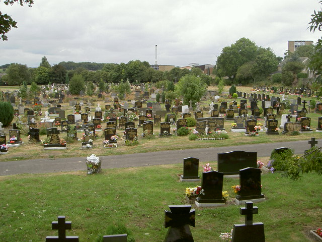
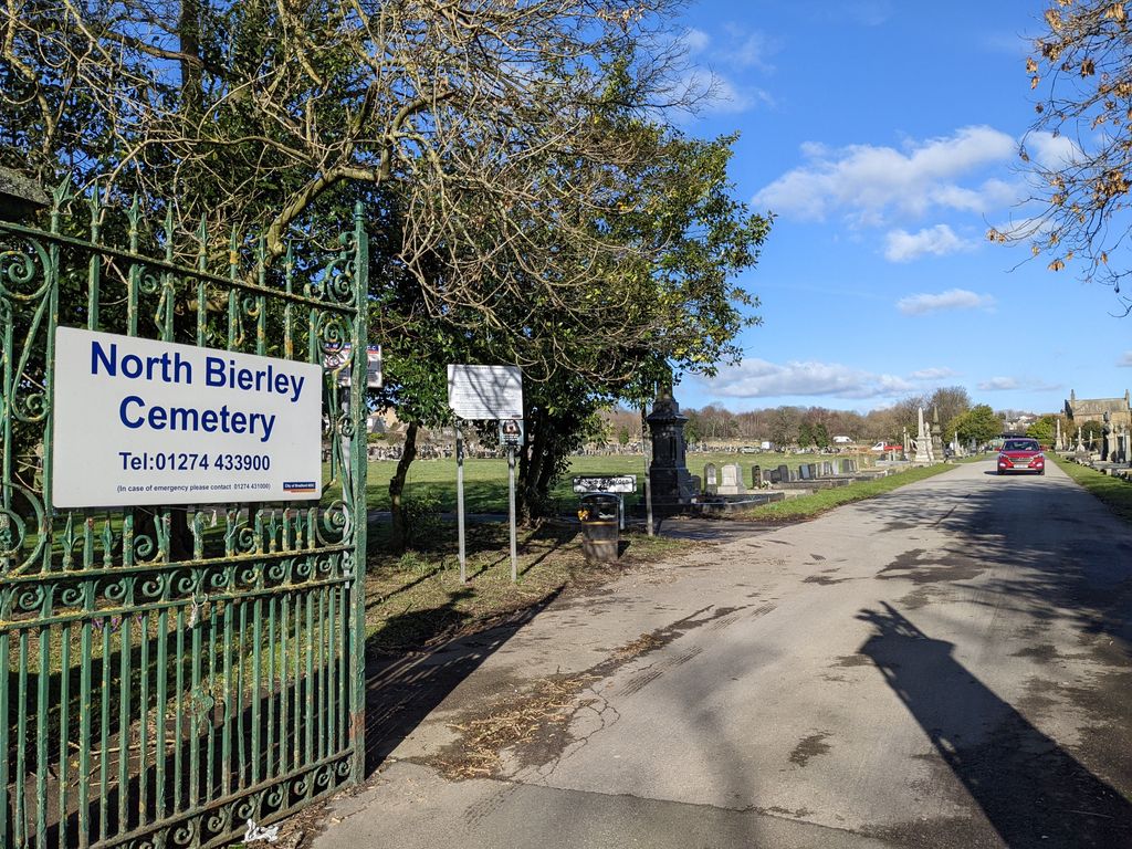
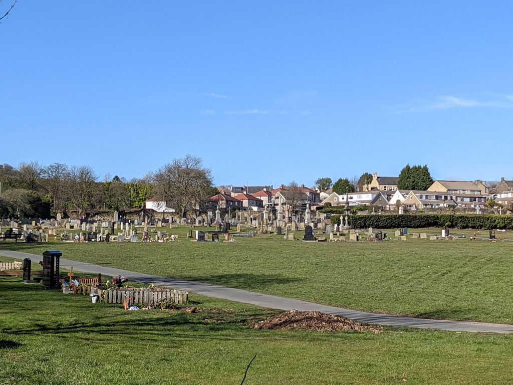
| Description | : | North Bierley Cemetery is off Halifax Road at Buttershaw and can be accessed from either Abb Scott Lane or Cemetery Road. The postcode of the former lodge in Cemetery Road, now a private house, is BD6 2NG. It was laid out in 1902 and the first interment took place on January 2nd 1903. The cemetery covers an area of 18 acres and is divided into two sections – consecrated and non-consecrated. As you come in through the gates from Cemetery Road the old lodge (now a private house) is on your left and the main pathway or terrace is in... Read More |
frequently asked questions (FAQ):
-
Where is North Bierley Municipal Cemetery?
North Bierley Municipal Cemetery is located at Cemetery Road Bradford, Metropolitan Borough of Bradford ,West Yorkshire , BD6 2NGEngland.
-
North Bierley Municipal Cemetery cemetery's updated grave count on graveviews.com?
4 memorials
-
Where are the coordinates of the North Bierley Municipal Cemetery?
Latitude: 53.7584470
Longitude: -1.7781560
Nearby Cemetories:
1. St. Paul Churchyard
Wibsey, Metropolitan Borough of Bradford, England
Coordinate: 53.7636700, -1.7784700
2. St Mark Churchyard
Low Moor, Metropolitan Borough of Bradford, England
Coordinate: 53.7512500, -1.7696100
3. Wibsey Salvation Army Memorial Garden
Wibsey, Metropolitan Borough of Bradford, England
Coordinate: 53.7664200, -1.7702900
4. Zion Congregationalist Church Graveyard
Bradford, Metropolitan Borough of Bradford, England
Coordinate: 53.7681900, -1.7702550
5. Holy Trinity Churchyard
Low Moor, Metropolitan Borough of Bradford, England
Coordinate: 53.7564900, -1.7590000
6. St. Matthew Churchyard
Bradford, Metropolitan Borough of Bradford, England
Coordinate: 53.7689950, -1.7638640
7. Wesley Place Methodist Chapelyard
Low Moor, Metropolitan Borough of Bradford, England
Coordinate: 53.7528600, -1.7573100
8. St. Michael & All Angels Churchyard
Shelf, Metropolitan Borough of Calderdale, England
Coordinate: 53.7573400, -1.8030500
9. Pollard Family Burial Ground
Shelf, Metropolitan Borough of Calderdale, England
Coordinate: 53.7570244, -1.8072409
10. Bethel Methodist Chapelyard
Shelf, Metropolitan Borough of Calderdale, England
Coordinate: 53.7563530, -1.8079900
11. Witchfield Wesleyan Methodist Church
Shelf, Metropolitan Borough of Calderdale, England
Coordinate: 53.7559447, -1.8114241
12. Friends Burial Ground
Bradford, Metropolitan Borough of Bradford, England
Coordinate: 53.7788470, -1.7747890
13. Wade House Primitive Methodist Church
Shelf, Metropolitan Borough of Calderdale, England
Coordinate: 53.7543871, -1.8140742
14. St. Mary the Virgin Churchyard
Wyke, Metropolitan Borough of Bradford, England
Coordinate: 53.7363400, -1.7715600
15. Great Horton Methodist Churchyard
Bradford, Metropolitan Borough of Bradford, England
Coordinate: 53.7813052, -1.7849559
16. St Stephen Churchyard
West Bowling, Metropolitan Borough of Bradford, England
Coordinate: 53.7783440, -1.7578570
17. Westfield United Reform Chapel
Wyke, Metropolitan Borough of Bradford, England
Coordinate: 53.7355456, -1.7629691
18. Bowling Cemetery
West Bowling, Metropolitan Borough of Bradford, England
Coordinate: 53.7714844, -1.7370390
19. St John the Baptist Churchyard
Coley, Metropolitan Borough of Calderdale, England
Coordinate: 53.7385570, -1.8119940
20. Clayton Heights Methodist Chapelyard
Bradford, Metropolitan Borough of Bradford, England
Coordinate: 53.7705400, -1.8227400
21. Lower Wyke Moravian Churchyard
Wyke, Metropolitan Borough of Bradford, England
Coordinate: 53.7295640, -1.7735920
22. St. John the Evangelist Churchyard
Bradford, Metropolitan Borough of Bradford, England
Coordinate: 53.7705297, -1.7323057
23. Scholemoor Cemetery and Crematorium
Bradford, Metropolitan Borough of Bradford, England
Coordinate: 53.7875404, -1.7963200
24. St Philip and St James Church Memorial Garden
Cleckheaton, Metropolitan Borough of Kirklees, England
Coordinate: 53.7291800, -1.7481500