
| Memorials | : | 0 |
| Location | : | Shelf, Metropolitan Borough of Calderdale, England |
| Coordinate | : | 53.7570244, -1.8072409 |
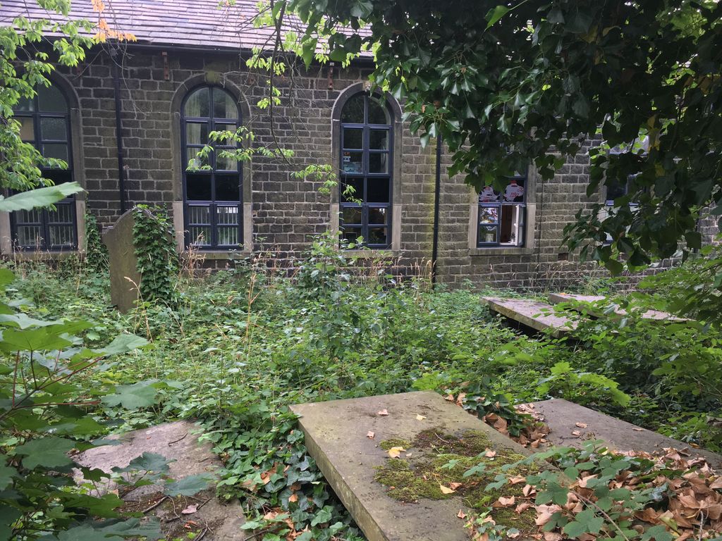
| Description | : | The Pollard family reserved land at the side of Carr House School in Shelf to use as a private burial ground for members of their family. John Pollard (1755-1833) stated in his will that “I have enclosed and appropriated a plot of ground for a family burial place...it is my will that my body shall be interred in the said burial place by the side of my said son William” and left the land “to be used as a Family Burial Place for my descendants and their Families for ever.” Many of the stones are now hidden by undergrowth but... Read More |
frequently asked questions (FAQ):
-
Where is Pollard Family Burial Ground?
Pollard Family Burial Ground is located at Carr House Lane Shelf, Metropolitan Borough of Calderdale ,West Yorkshire ,England.
-
Pollard Family Burial Ground cemetery's updated grave count on graveviews.com?
0 memorials
-
Where are the coordinates of the Pollard Family Burial Ground?
Latitude: 53.7570244
Longitude: -1.8072409
Nearby Cemetories:
1. Bethel Methodist Chapelyard
Shelf, Metropolitan Borough of Calderdale, England
Coordinate: 53.7563530, -1.8079900
2. St. Michael & All Angels Churchyard
Shelf, Metropolitan Borough of Calderdale, England
Coordinate: 53.7573400, -1.8030500
3. Witchfield Wesleyan Methodist Church
Shelf, Metropolitan Borough of Calderdale, England
Coordinate: 53.7559447, -1.8114241
4. Wade House Primitive Methodist Church
Shelf, Metropolitan Borough of Calderdale, England
Coordinate: 53.7543871, -1.8140742
5. Clayton Heights Methodist Chapelyard
Bradford, Metropolitan Borough of Bradford, England
Coordinate: 53.7705400, -1.8227400
6. North Bierley Municipal Cemetery
Bradford, Metropolitan Borough of Bradford, England
Coordinate: 53.7584470, -1.7781560
7. St. Paul Churchyard
Wibsey, Metropolitan Borough of Bradford, England
Coordinate: 53.7636700, -1.7784700
8. St John the Baptist Churchyard
Coley, Metropolitan Borough of Calderdale, England
Coordinate: 53.7385570, -1.8119940
9. St Mark Churchyard
Low Moor, Metropolitan Borough of Bradford, England
Coordinate: 53.7512500, -1.7696100
10. Wibsey Salvation Army Memorial Garden
Wibsey, Metropolitan Borough of Bradford, England
Coordinate: 53.7664200, -1.7702900
11. Zion Congregationalist Church Graveyard
Bradford, Metropolitan Borough of Bradford, England
Coordinate: 53.7681900, -1.7702550
12. Heywood United Reformed Chapelyard
Northowram, Metropolitan Borough of Calderdale, England
Coordinate: 53.7369550, -1.8325630
13. Queensbury Cemetery
Queensbury, Metropolitan Borough of Bradford, England
Coordinate: 53.7666270, -1.8478510
14. Clayton Methodist Chapelyard
Clayton, Metropolitan Borough of Bradford, England
Coordinate: 53.7812800, -1.8232500
15. Holy Trinity Churchyard
Queensbury, Metropolitan Borough of Bradford, England
Coordinate: 53.7670300, -1.8485400
16. Queensbury Baptist Church
Queensbury, Metropolitan Borough of Bradford, England
Coordinate: 53.7690533, -1.8469805
17. Clayton Baptist Churchyard
Clayton, Metropolitan Borough of Bradford, England
Coordinate: 53.7830600, -1.8192200
18. Great Horton Methodist Churchyard
Bradford, Metropolitan Borough of Bradford, England
Coordinate: 53.7813052, -1.7849559
19. St John the Baptist Churchyard
Clayton, Metropolitan Borough of Bradford, England
Coordinate: 53.7836900, -1.8210500
20. St. Matthew Churchyard
Bradford, Metropolitan Borough of Bradford, England
Coordinate: 53.7689950, -1.7638640
21. Holy Trinity Churchyard
Low Moor, Metropolitan Borough of Bradford, England
Coordinate: 53.7564900, -1.7590000
22. Friends Burial Ground
Bradford, Metropolitan Borough of Bradford, England
Coordinate: 53.7788470, -1.7747890
23. St. Mary the Virgin Churchyard
Wyke, Metropolitan Borough of Bradford, England
Coordinate: 53.7363400, -1.7715600
24. Wesley Place Methodist Chapelyard
Low Moor, Metropolitan Borough of Bradford, England
Coordinate: 53.7528600, -1.7573100