

1LT Daniel Lafayette Acres
| Birth | : | 1840 |
| Death | : | 20 Aug 1864 |
| Burial | : | Newton Road Cemetery, Rushden, East Northamptonshire Borough, England |
| Coordinate | : | 52.2882140, -0.5859750 |
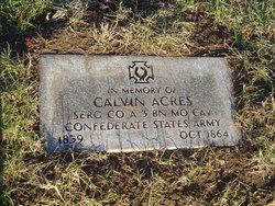
| Description | : | The California Democrat, Missouri, June 18, 2009 - CONFEDERAT E VETERANS HONORED IN CEREMONY - By DAVID A. WILSON, Democrat Staff Members of the M.M. Parsons Camp of the Sons of Confederate Veterans visited California Saturday, March 21, to decorate the gravestones of three veterans of the Civil War who fought on the Confederate side. The markers for three brothers, two of which never returned from the war, were recognized and decorated with battle flags. All three brothers served in Company A, Third Battalion, Missouri Calvary, Confederate States of America. Calvin Acres, born 1839, served as sergeant. Daniel Lafayette Acres, born 1840, served as lieutenant.... Read More |
frequently asked questions (FAQ):
-
Where is 1LT Daniel Lafayette Acres's memorial?
1LT Daniel Lafayette Acres's memorial is located at: Newton Road Cemetery, Rushden, East Northamptonshire Borough, England.
-
When did 1LT Daniel Lafayette Acres death?
1LT Daniel Lafayette Acres death on 20 Aug 1864 in
-
Where are the coordinates of the 1LT Daniel Lafayette Acres's memorial?
Latitude: 52.2882140
Longitude: -0.5859750
Family Members:
Parent

Siblings
Flowers:


Nearby Cemetories:
1. Newton Road Cemetery
Rushden, East Northamptonshire Borough, England
Coordinate: 52.2882140, -0.5859750
2. St Mary Churchyard
Rushden, East Northamptonshire Borough, England
Coordinate: 52.2885570, -0.5973860
3. St. Mary the Virgin Churchyard
Higham Ferrers, East Northamptonshire Borough, England
Coordinate: 52.3065500, -0.5915240
4. Higham Ferrers Cemetery
Higham Ferrers, East Northamptonshire Borough, England
Coordinate: 52.3084850, -0.5945270
5. St Lawrence Churchyard
Wymington, Bedford Borough, England
Coordinate: 52.2694310, -0.6017230
6. St. Peter Churchyard
Newton Bromswold, East Northamptonshire Borough, England
Coordinate: 52.2815200, -0.5376600
7. St. John the Baptist Churchyard
Chelveston, East Northamptonshire Borough, England
Coordinate: 52.3112800, -0.5501200
8. Irchester Saint Katherine Churchyard
Irchester, Wellingborough Borough, England
Coordinate: 52.2843900, -0.6446900
9. Irchester Cemetery
Irchester, Wellingborough Borough, England
Coordinate: 52.2848000, -0.6456000
10. New Irthlingborough Cemetery
Irthlingborough, East Northamptonshire Borough, England
Coordinate: 52.3178531, -0.6294229
11. St Peter's Churchyard
Irthlingborough, East Northamptonshire Borough, England
Coordinate: 52.3251642, -0.6101925
12. St Mary the Virgin Churchyard
Podington, Bedford Borough, England
Coordinate: 52.2539100, -0.6220900
13. St. Mary the Virgin Churchyard
Yelden, Bedford Borough, England
Coordinate: 52.2930600, -0.5182700
14. St. Michael's Church
Farndish, Bedford Borough, England
Coordinate: 52.2638108, -0.6416839
15. St. Margaret of Antioch Churchyard
Knotting, Bedford Borough, England
Coordinate: 52.2599172, -0.5323686
16. Stanwick Cemetery
Stanwick, East Northamptonshire Borough, England
Coordinate: 52.3298800, -0.5531500
17. St. Laurence Churchyard Stanwick
Stanwick, East Northamptonshire Borough, England
Coordinate: 52.3324970, -0.5628585
18. All Saints Churchyard
Souldrop, Bedford Borough, England
Coordinate: 52.2433000, -0.5584000
19. St. Mary Magdalene Churchyard
Melchbourne, Bedford Borough, England
Coordinate: 52.2770600, -0.4935690
20. Wollaston
Wollaston, Wellingborough Borough, England
Coordinate: 52.2581088, -0.6726313
21. London Road Cemetery
Wellingborough, Wellingborough Borough, England
Coordinate: 52.2986000, -0.6878000
22. All Saints Churchyard
Wellingborough, Wellingborough Borough, England
Coordinate: 52.3010890, -0.6879730
23. St Mary the Virgin Churchyard
Shelton, Bedford Borough, England
Coordinate: 52.3076000, -0.4852000
24. Raunds Cemetery
Raunds, East Northamptonshire Borough, England
Coordinate: 52.3494100, -0.5467400