Addie Josephine McKee Thurman
| Birth | : | 5 Mar 1888 Cedarville, Dade County, Missouri, USA |
| Death | : | 5 Jul 1965 Skagit County, Washington, USA |
| Burial | : | St Wilfrids Churchyard, Melling, City of Lancaster, England |
| Coordinate | : | 54.1346900, -2.6165100 |
| Plot | : | Old Section |
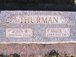
| Inscription | : | THURMAN JOHN B. ------ ADDIE J. 1881-1956 --- 1888-1965 |
| Description | : | Father: Robert McKee Mother: Sarah C. Munhale Addie J. McKee (19) married John B. Blythe (26) on 27 November 1907 in Avon, Mount Vernon, Skagit County, Washington. =========================== ADDIE J. THURMAN Mrs. Addie J. Thurman, age 77, resident of Skagit County for the past 60 years, died on Monday morning at United General Hospital. She was born March 5, 1888 in Dade County, Missouri, and came to Skagit County in 1905. Her marriage to John B. Thurman took place November 19, 1907, in Mount Vernon. The family had farmed for many years in the Allen area,... Read More |
frequently asked questions (FAQ):
-
Where is Addie Josephine McKee Thurman's memorial?
Addie Josephine McKee Thurman's memorial is located at: St Wilfrids Churchyard, Melling, City of Lancaster, England.
-
When did Addie Josephine McKee Thurman death?
Addie Josephine McKee Thurman death on 5 Jul 1965 in Skagit County, Washington, USA
-
Where are the coordinates of the Addie Josephine McKee Thurman's memorial?
Latitude: 54.1346900
Longitude: -2.6165100
Family Members:
Spouse
Children
Flowers:
Nearby Cemetories:
1. St Wilfrids Churchyard
Melling, City of Lancaster, England
Coordinate: 54.1346900, -2.6165100
2. St John The Baptist Churchyard
Arkholme, City of Lancaster, England
Coordinate: 54.1406220, -2.6307800
3. St James the Less Churchyard
Tatham, City of Lancaster, England
Coordinate: 54.1190100, -2.6043200
4. St. Wilfred Priory
Hornby, City of Lancaster, England
Coordinate: 54.1143640, -2.6405490
5. St. John The Evangelist Churchyard
Gressingham, City of Lancaster, England
Coordinate: 54.1233910, -2.6557800
6. St. Margaret's Churchyard
Hornby, City of Lancaster, England
Coordinate: 54.1114000, -2.6362000
7. St John The Baptist Churchyard
Tunstall, City of Lancaster, England
Coordinate: 54.1596600, -2.5924200
8. Holy Trinity Churchyard
Wray, City of Lancaster, England
Coordinate: 54.1022960, -2.6081510
9. St. John the Baptist Churchyard
Bentham, Craven District, England
Coordinate: 54.1180880, -2.5454540
10. St. Michael the Archangel Churchyard
Whittington, City of Lancaster, England
Coordinate: 54.1807620, -2.6148790
11. Friends Burial Group
Bentham, Craven District, England
Coordinate: 54.1265450, -2.5374290
12. All Saints Churchyard
Burton-in-Lonsdale, Craven District, England
Coordinate: 54.1437630, -2.5357130
13. St. Chad's Churchyard
Claughton, City of Lancaster, England
Coordinate: 54.0931310, -2.6643990
14. St. Saviour's Church
Halton, City of Lancaster, England
Coordinate: 54.1025610, -2.6891750
15. Saint Peter's Churchyard
Leck, City of Lancaster, England
Coordinate: 54.1836860, -2.5485980
16. St Margaret Churchyard
Bentham, Craven District, England
Coordinate: 54.1146000, -2.5087300
17. St Cuthbert Churchyard
Over Kellet, City of Lancaster, England
Coordinate: 54.1195480, -2.7318200
18. St Mary the Virgin Churchyard
Kirkby Lonsdale, South Lakeland District, England
Coordinate: 54.2036550, -2.5976790
19. Church of the Good Shepherd Churchyard
Tatham, City of Lancaster, England
Coordinate: 54.0830170, -2.5301250
20. St John's Churchyard
Hutton Roof, South Lakeland District, England
Coordinate: 54.2029600, -2.6615600
21. St. Paul Churchyard
Caton, City of Lancaster, England
Coordinate: 54.0757840, -2.7009980
22. St James Churchyard
Burton-in-Kendal, South Lakeland District, England
Coordinate: 54.1859270, -2.7210310
23. Holy Trinity Churchyard
Casterton, South Lakeland District, England
Coordinate: 54.2113570, -2.5768860
24. St Oswald Churchyard
Thornton-in-Lonsdale, Craven District, England
Coordinate: 54.1573600, -2.4830810

