
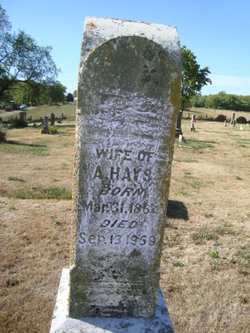
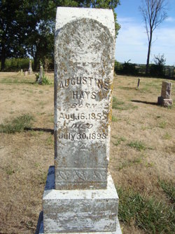
Adra Lida Carroll Hays
| Birth | : | 31 Mar 1864 Tennessee, USA |
| Death | : | 13 Sep 1959 Caldwell County, Missouri, USA |
| Burial | : | Tinney Grove Cemetery, Tinney Grove, Ray County, USA |
| Coordinate | : | 39.5066280, -93.8050000 |
| Description | : | Mrs Adra Lyda Hays, 95, a lifetime resident of the Tinneys Point Community south of Braymer died at the home of her son, Lester Hays in Braymer at 4 pm Sunday. She had been ill for some time. Funeral services will be held from the chapel of the Michael Funeral Home in Braymer at 2 o'clock Tuesday afternoon, conducted by the Rev Lawrence Wheeler. Burial will be at Tinneys Point. Mrs Hays is survived by two sons, Willie and Lester Hays, both of Braymer; two daughters, Mrs Jessie Fields, Cowgill, and Mrs Florence Hayes, Hardin; 39 grandchildren and several great-grandchildren. Chillicothe Constitution, Monday,... Read More |
frequently asked questions (FAQ):
-
Where is Adra Lida Carroll Hays's memorial?
Adra Lida Carroll Hays's memorial is located at: Tinney Grove Cemetery, Tinney Grove, Ray County, USA.
-
When did Adra Lida Carroll Hays death?
Adra Lida Carroll Hays death on 13 Sep 1959 in Caldwell County, Missouri, USA
-
Where are the coordinates of the Adra Lida Carroll Hays's memorial?
Latitude: 39.5066280
Longitude: -93.8050000
Family Members:
Parent
Spouse
Siblings
Children


Nearby Cemetories:
1. Tinney Grove Cemetery
Tinney Grove, Ray County, USA
Coordinate: 39.5066280, -93.8050000
2. Elder Cemetery
Grape Grove Township, Ray County, USA
Coordinate: 39.5015259, -93.8108826
3. Graff Cemetery
Grape Grove Township, Ray County, USA
Coordinate: 39.4909286, -93.8144836
4. McBee Chapel Cemetery
Carroll County, USA
Coordinate: 39.5239983, -93.7559967
5. Little Union Cemetery
Stet, Ray County, USA
Coordinate: 39.4972343, -93.8660507
6. Black Oak Cemetery
Braymer, Caldwell County, USA
Coordinate: 39.5469017, -93.8403473
7. Basham Cemetery
Ray County, USA
Coordinate: 39.4963400, -93.8810700
8. Silas Keith Cemetery
Regal, Ray County, USA
Coordinate: 39.4387800, -93.8262100
9. Oster Cemetery
Caldwell County, USA
Coordinate: 39.5684400, -93.7622100
10. Tevalt-Northern Sympathizers Cemetery
Carroll County, USA
Coordinate: 39.4593010, -93.7379990
11. McCuistion Cemetery
Richmond, Ray County, USA
Coordinate: 39.4387300, -93.8550900
12. Old New Hope Cemetery
Millville, Ray County, USA
Coordinate: 39.4327200, -93.8435900
13. Low Gap Cemetery
Norborne, Carroll County, USA
Coordinate: 39.5244000, -93.7024000
14. Bethany Church Cemetery
Stet, Ray County, USA
Coordinate: 39.4230995, -93.7838974
15. Mount Olivet Cemetery
Stet, Carroll County, USA
Coordinate: 39.4366000, -93.7403000
16. New Hope United Methodist Church Cemetery
Millville, Ray County, USA
Coordinate: 39.4236259, -93.8416061
17. Evergreen Cemetery
Braymer, Caldwell County, USA
Coordinate: 39.5986290, -93.7981720
18. Antioch Cemetery
Millville, Ray County, USA
Coordinate: 39.4563040, -93.9077420
19. Union Baptist Church Cemetery
Roads, Carroll County, USA
Coordinate: 39.4486008, -93.7021027
20. Van Wall Cemetery
Grape Grove Township, Ray County, USA
Coordinate: 39.4513800, -93.9116700
21. Cowgill Cemetery
Cowgill, Caldwell County, USA
Coordinate: 39.5531311, -93.9222488
22. Petree Cemetery
Taitsville, Ray County, USA
Coordinate: 39.4781700, -93.9315100
23. Mansur Cemetery
Grape Grove Township, Ray County, USA
Coordinate: 39.4230003, -93.8804016
24. Yoakum Cemetery
Richmond, Ray County, USA
Coordinate: 39.4909100, -93.9380500