
| Birth | : | 17 Aug 1848 Bailiwick of Guernsey |
| Death | : | 2 Mar 1927 Fulton County, Ohio, USA |
| Burial | : | Evergreen Cemetery, Grand Forks, Kootenay Boundary Regional District, Canada |
| Coordinate | : | 49.0243650, -118.4520650 |
| Inscription | : | Father |
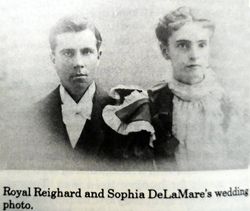
| Description | : | Alfred de La Mare has developed a valuable farm in Swan Creek Township, and is recognized as one of the representatives of the agricultural class in Fulton county. He was born on the Island of Guernsey in August, 1848, a son of John and Sophia (DeGaris) de La Mare, also natives of the Island of Guernsey, who came to the United States in 1861. After a short period spent in Cuyahoga county, Ohio, they came to Swan Creek Township, buying eighty acres of partly cleared and improved land, of which they later sold their son Alfred half, residing on the... Read More |
frequently asked questions (FAQ):
-
Where is Alfred De La Mare's memorial?
Alfred De La Mare's memorial is located at: Evergreen Cemetery, Grand Forks, Kootenay Boundary Regional District, Canada.
-
When did Alfred De La Mare death?
Alfred De La Mare death on 2 Mar 1927 in Fulton County, Ohio, USA
-
Where are the coordinates of the Alfred De La Mare's memorial?
Latitude: 49.0243650
Longitude: -118.4520650
Family Members:
Parent

Spouse
Siblings
Children
Flowers:


Nearby Cemetories:
1. Evergreen Cemetery
Grand Forks, Kootenay Boundary Regional District, Canada
Coordinate: 49.0243650, -118.4520650
2. Outlook Khristovoye Doukhobor Cemetery
Grand Forks, Kootenay Boundary Regional District, Canada
Coordinate: 49.0402930, -118.4835600
3. USCC Sion Cemetery
Grand Forks, Kootenay Boundary Regional District, Canada
Coordinate: 49.0159500, -118.4964300
4. Danville Cemetery
Ferry County, USA
Coordinate: 48.9885640, -118.5151702
5. Gilpin Cemetery # 1
Gilpin, Kootenay Boundary Regional District, Canada
Coordinate: 49.0090920, -118.3181980
6. Gilpin Cemetery # 2
Gilpin, Kootenay Boundary Regional District, Canada
Coordinate: 49.0084500, -118.3073490
7. Phoenix Cemetery
Greenwood, Kootenay Boundary Regional District, Canada
Coordinate: 49.1019000, -118.6285500
8. Cascade Cemetery
Cascade, Kootenay Boundary Regional District, Canada
Coordinate: 49.0188990, -118.2247300
9. Laurier Cemetery
Ferry County, USA
Coordinate: 48.9855500, -118.2189000
10. Curlew Indian Cemetery
Curlew, Ferry County, USA
Coordinate: 48.8811145, -118.6002982
11. Merritt Pioneer Grave
Curlew, Ferry County, USA
Coordinate: 48.8745300, -118.6020000
12. Curlew City Cemetery
Curlew, Ferry County, USA
Coordinate: 48.8734163, -118.6010599
13. Greenwood Cemetery
Greenwood, Kootenay Boundary Regional District, Canada
Coordinate: 49.1250200, -118.6836000
14. Village of Midway Cemetery
Midway, Kootenay Boundary Regional District, Canada
Coordinate: 49.0082520, -118.7609490
15. Ranald McDonald Cemetery
Toroda, Ferry County, USA
Coordinate: 48.9472094, -118.7617135
16. Somday Family Cemetery
Malo, Ferry County, USA
Coordinate: 48.8290000, -118.5990000
17. Orient Cemetery
Orient, Ferry County, USA
Coordinate: 48.8578987, -118.2032013
18. Eagle Cliff Cemetery
Toroda, Ferry County, USA
Coordinate: 48.9404375, -118.7946296
19. Kelly Hill Cemetery
Stevens County, USA
Coordinate: 48.8130989, -118.1268997
20. Pia Mission Cemetery
Stevens County, USA
Coordinate: 48.7960700, -118.1097300
21. Green Mountain Cemetery
Stevens County, USA
Coordinate: 48.7200180, -118.1178760
22. Bossburg Cemetery
Stevens County, USA
Coordinate: 48.7435989, -118.0485992
23. Thorp Cemetery
Chesaw, Okanogan County, USA
Coordinate: 48.9549900, -119.0316700
24. Chesaw Cemetery
Okanogan County, USA
Coordinate: 48.9299900, -119.0541800