
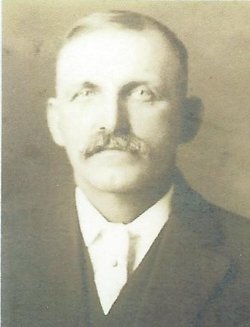

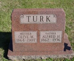
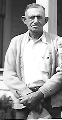
Alfred Henry Turk
| Birth | : | 13 Aug 1862 Rosecrans, Lake County, Illinois, USA |
| Death | : | 13 Jul 1936 Osceola, Clarke County, Iowa, USA |
| Burial | : | Visitation Catholic Cemetery, Stacyville, Mitchell County, USA |
| Coordinate | : | 43.4430618, -92.7813873 |
| Description | : | Son of Edward Harrison Turk (b. 16 Oct 1840 in Syracuse, Onondaga, NY) and Ann Edwards (b. Jan 1840 in England) Married on December 31, 1884 to Olive Marie Sibley (b. 29 Mar 1864 IL) Married on August 30, 1916, at Osceola Iowa to Mary Matilda "May" Bevans ---------- Funeral Services for Alfred Turk Were Held Tues.; Well Known Dairyman Here Osceola, Iowa, Thursday, July 16, 1936 Funeral services for Alfred H. (Henry) Turk were held from the Webster Funeral Home, Tuesday afternoon at 2:30, conducted by Rev. F. C. McCallon, pastor of the Church of Christ,... Read More |
frequently asked questions (FAQ):
-
Where is Alfred Henry Turk's memorial?
Alfred Henry Turk's memorial is located at: Visitation Catholic Cemetery, Stacyville, Mitchell County, USA.
-
When did Alfred Henry Turk death?
Alfred Henry Turk death on 13 Jul 1936 in Osceola, Clarke County, Iowa, USA
-
Where are the coordinates of the Alfred Henry Turk's memorial?
Latitude: 43.4430618
Longitude: -92.7813873
Family Members:
Parent

Spouse

Children

Flowers:


Nearby Cemetories:
1. Stacyville Cemetery
Stacyville, Mitchell County, USA
Coordinate: 43.4294014, -92.7908020
2. Union Presbyterian Cemetery
Stacyville, Mitchell County, USA
Coordinate: 43.4797211, -92.8088913
3. Union Township Cemetery
Toeterville, Mitchell County, USA
Coordinate: 43.4578018, -92.8491974
4. Sacred Heart Cemetery
Meyer, Mitchell County, USA
Coordinate: 43.4583282, -92.7011108
5. Saint Johns Cemetery
Johnsburg, Mower County, USA
Coordinate: 43.5055618, -92.7688904
6. Liberty Cemetery
Little Cedar, Mitchell County, USA
Coordinate: 43.3856010, -92.7230988
7. Saint Peter Cemetery
Toeterville, Mitchell County, USA
Coordinate: 43.4402809, -92.8897171
8. Robbins Cemetery
David (historical), Mitchell County, USA
Coordinate: 43.4150009, -92.6718979
9. Six Mile Grove Cemetery
Lyle, Mower County, USA
Coordinate: 43.5069389, -92.8836136
10. Saint Patricks Church Cemetery
McIntire, Mitchell County, USA
Coordinate: 43.4771996, -92.6508026
11. Saint Ansgar Cemetery
Saint Ansgar, Mitchell County, USA
Coordinate: 43.3777809, -92.9094391
12. Rustad Cemetery
Otranto, Mitchell County, USA
Coordinate: 43.4585991, -92.9400024
13. First Lutheran Cemetery
Saint Ansgar, Mitchell County, USA
Coordinate: 43.3841705, -92.9194412
14. Mona Cemetery
Mona, Mitchell County, USA
Coordinate: 43.4824982, -92.9402771
15. McKinley Cemetery
Saint Ansgar, Mitchell County, USA
Coordinate: 43.3906400, -92.9368300
16. Pleasant Hill Cemetery
Mona, Mitchell County, USA
Coordinate: 43.4768982, -92.9467010
17. Immanuel Lutheran Cemetery
Saint Ansgar, Mitchell County, USA
Coordinate: 43.3717003, -92.9257965
18. Sacred Heart Cemetery
Adams, Mower County, USA
Coordinate: 43.5635986, -92.7221985
19. Beaver Creek Cemetery
Brownville, Mitchell County, USA
Coordinate: 43.3397217, -92.6727829
20. Little Cedar Cemetery
Adams, Mower County, USA
Coordinate: 43.5736008, -92.7574997
21. Ogden Cemetery
Otranto, Mitchell County, USA
Coordinate: 43.4366989, -92.9681015
22. Blakestad Cemetery
Saint Ansgar, Mitchell County, USA
Coordinate: 43.3711014, -92.9400024
23. Riverview Cemetery
Saint Ansgar, Mitchell County, USA
Coordinate: 43.3430328, -92.9220200
24. Oak Grove Cemetery
Mitchell, Mitchell County, USA
Coordinate: 43.3156013, -92.8707962