
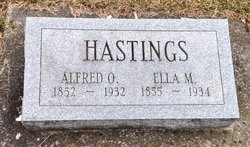
Alfred Orla Hastings
| Birth | : | 11 Jan 1852 Defiance County, Ohio, USA |
| Death | : | 19 Aug 1932 Farmer, Defiance County, Ohio, USA |
| Burial | : | Farmer Cemetery, Farmer, Defiance County, USA |
| Coordinate | : | 41.3903008, -84.6410980 |
| Description | : | Alfred O. Hastings, 80, who had resided in Farmer township all of his life except five years when a young man in Nebraska, died Friday at 1 p.m. at his home a quarter of a mile west of here. In November, he suffered a light stroke of paralysis and had been in failing health since. On Aug. 11 he suffered his final stroke. Mr. Hastings, who was born Feb. 11, 1852 a half mile west and a quarter of a mile north of Farmer, had lived there until the house burned a year ago in January when he moved a quarter... Read More |
frequently asked questions (FAQ):
-
Where is Alfred Orla Hastings's memorial?
Alfred Orla Hastings's memorial is located at: Farmer Cemetery, Farmer, Defiance County, USA.
-
When did Alfred Orla Hastings death?
Alfred Orla Hastings death on 19 Aug 1932 in Farmer, Defiance County, Ohio, USA
-
Where are the coordinates of the Alfred Orla Hastings's memorial?
Latitude: 41.3903008
Longitude: -84.6410980
Family Members:
Parent

Spouse

Siblings

Children
Flowers:


Nearby Cemetories:
1. Farmer Cemetery
Farmer, Defiance County, USA
Coordinate: 41.3903008, -84.6410980
2. Upper Lost Creek Cemetery
Farmer, Defiance County, USA
Coordinate: 41.3840000, -84.6700000
3. Kemp Cemetery
Defiance County, USA
Coordinate: 41.3703003, -84.6802979
4. Lost Creek Cemetery
Farmer, Defiance County, USA
Coordinate: 41.3553000, -84.6700000
5. Williams Center Cemetery
Williams Center, Williams County, USA
Coordinate: 41.4288902, -84.6125031
6. Tamarack Cemetery
Milford Township, Defiance County, USA
Coordinate: 41.4117012, -84.7089005
7. Zion Lutheran Church Cemetery
Defiance County, USA
Coordinate: 41.4261017, -84.7099991
8. Fetters Cemetery
Williams County, USA
Coordinate: 41.4519500, -84.6159900
9. Melbern-Neihardt Cemetery
Melbern, Williams County, USA
Coordinate: 41.4633600, -84.6416330
10. Lintz Cemetery
Ney, Defiance County, USA
Coordinate: 41.3760986, -84.5402985
11. Trinity Lutheran Cemetery
Ney, Defiance County, USA
Coordinate: 41.4016991, -84.5353012
12. Yackee Cemetery
Williams County, USA
Coordinate: 41.4707985, -84.6324997
13. Ney Cemetery
Ney, Defiance County, USA
Coordinate: 41.3856010, -84.5271988
14. Six Corners Cemetery
Hicksville, Defiance County, USA
Coordinate: 41.3213997, -84.7153015
15. Saint Johns Lutheran Cemetery
Sherwood, Defiance County, USA
Coordinate: 41.3092003, -84.5931015
16. Doud Cemetery
Ney, Defiance County, USA
Coordinate: 41.3811680, -84.5161110
17. Fountain Grove Cemetery
Bryan, Williams County, USA
Coordinate: 41.4572182, -84.5480576
18. Thomas Cemetery
Williams County, USA
Coordinate: 41.4769100, -84.6994240
19. Brown Cemetery
Bryan, Williams County, USA
Coordinate: 41.4822006, -84.5935974
20. Maple Grove Cemetery
Edgerton, Williams County, USA
Coordinate: 41.4435997, -84.7521973
21. St. Mary's Cemetery
Edgerton, Williams County, USA
Coordinate: 41.4441120, -84.7542700
22. Clarksville Cemetery
Edgerton, Williams County, USA
Coordinate: 41.4281006, -84.7677994
23. Auglaize Village Cemetery
Defiance, Defiance County, USA
Coordinate: 41.3399760, -84.5165610
24. Funk Cemetery
Defiance County, USA
Coordinate: 41.3396988, -84.5164032