
| Birth | : | 17 Dec 1906 Missouri Valley, Harrison County, Iowa, USA |
| Death | : | 25 Apr 1991 Carroll, Carroll County, Iowa, USA |
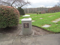
| Burial | : | Walnut Hill Cemetery, Council Bluffs, Pottawattamie County, USA |
| Coordinate | : | 41.2719002, -95.8255997 |
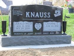
| Description | : | OBITUARY MRS. ALICE CATHERINE KNAUSS Graveside service for Mrs. Alice Catherine Knauss will be Saturday, April 27, 1991, at 1l:30 a.m. at Walnut Hill Cemetery In Council Bluffs. Mrs. Knauss. 84, of Carroll and formerly of Council Bluffs, died Thursday, April 25, 1991, at the Carroll Health Center in Carroll, following a lingering Illness. The Rev. Dr. James Poulsen of Broadway United Methodist Church In Council Bluffs will officiate. Visitation will be from 7 to 8 p.m. today at Dahn and Woodhouse Funeral Home in Carroll. Casket bearers will be grandsons; Steven Knauss, Mark Knauss, Doug Knauss, David Knauss, Jerry Knauss,... Read More |
frequently asked questions (FAQ):
-
Where is Alice Catherine Cowan Knauss's memorial?
Alice Catherine Cowan Knauss's memorial is located at: Walnut Hill Cemetery, Council Bluffs, Pottawattamie County, USA.
-
When did Alice Catherine Cowan Knauss death?
Alice Catherine Cowan Knauss death on 25 Apr 1991 in Carroll, Carroll County, Iowa, USA
-
Where are the coordinates of the Alice Catherine Cowan Knauss's memorial?
Latitude: 41.2719002
Longitude: -95.8255997
Family Members:
Parent

Spouse
Siblings
Children
Flowers:


Nearby Cemetories:
1. Walnut Hill Cemetery
Council Bluffs, Pottawattamie County, USA
Coordinate: 41.2719002, -95.8255997
2. Bikhor Cholim Cemetery
Council Bluffs, Pottawattamie County, USA
Coordinate: 41.2703670, -95.8229350
3. Ridgewood Cemetery
Council Bluffs, Pottawattamie County, USA
Coordinate: 41.2694016, -95.8272018
4. Oak Hill Cemetery
Council Bluffs, Pottawattamie County, USA
Coordinate: 41.2700900, -95.8226400
5. Green Valley Cemetery
Council Bluffs, Pottawattamie County, USA
Coordinate: 41.2743988, -95.8225021
6. Saint Joseph Cemetery
Council Bluffs, Pottawattamie County, USA
Coordinate: 41.2722015, -95.8208008
7. Cedar Lawn Cemetery
Council Bluffs, Pottawattamie County, USA
Coordinate: 41.2694016, -95.8182983
8. Memorial Park Cemetery
Council Bluffs, Pottawattamie County, USA
Coordinate: 41.2644005, -95.8261032
9. Clark Cemetery
Pottawattamie County, USA
Coordinate: 41.2551610, -95.8223390
10. Fairview Cemetery
Council Bluffs, Pottawattamie County, USA
Coordinate: 41.2703018, -95.8480988
11. Garner Cemetery
Council Bluffs, Pottawattamie County, USA
Coordinate: 41.2956161, -95.8001709
12. Stoker-Graybill Cemetery
Council Bluffs, Pottawattamie County, USA
Coordinate: 41.2532620, -95.7751770
13. Maple Grove Cemetery
Council Bluffs, Pottawattamie County, USA
Coordinate: 41.2265560, -95.8187100
14. Evans Cemetery
Crescent, Pottawattamie County, USA
Coordinate: 41.3255997, -95.8368988
15. Lewis Township Cemetery
Council Bluffs, Pottawattamie County, USA
Coordinate: 41.2117004, -95.7938995
16. Gregg Cemetery
Weston, Pottawattamie County, USA
Coordinate: 41.3330000, -95.7931000
17. Council Point Cemetery
Council Bluffs, Pottawattamie County, USA
Coordinate: 41.2110830, -95.8788610
18. Hazel Dell Cemetery
Council Bluffs, Pottawattamie County, USA
Coordinate: 41.3489723, -95.7939911
19. Trinity Cathedral Columbarium
Omaha, Douglas County, USA
Coordinate: 41.2603900, -95.9393660
20. Saint Columbanus Cemetery
Weston, Pottawattamie County, USA
Coordinate: 41.3429440, -95.7435260
21. Crescent Cemetery
Crescent, Pottawattamie County, USA
Coordinate: 41.3664894, -95.8566208
22. Prospect Hill Cemetery
Omaha, Douglas County, USA
Coordinate: 41.2780991, -95.9593964
23. First Central Congregational Columbarium
Omaha, Douglas County, USA
Coordinate: 41.2563456, -95.9658365
24. Nash Chapel Crypt
Omaha, Douglas County, USA
Coordinate: 41.2665090, -95.9721790