
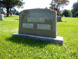
Alice Tyson Kohl
| Birth | : | 1860 |
| Death | : | 1946 |
| Burial | : | Raikes Road Burial Ground, Skipton, Craven District, England |
| Coordinate | : | 53.9643822, -2.0196819 |
frequently asked questions (FAQ):
-
Where is Alice Tyson Kohl's memorial?
Alice Tyson Kohl's memorial is located at: Raikes Road Burial Ground, Skipton, Craven District, England.
-
When did Alice Tyson Kohl death?
Alice Tyson Kohl death on 1946 in
-
Where are the coordinates of the Alice Tyson Kohl's memorial?
Latitude: 53.9643822
Longitude: -2.0196819
Family Members:
Parent

Spouse
Siblings
Children
Flowers:


Nearby Cemetories:
1. Raikes Road Burial Ground
Skipton, Craven District, England
Coordinate: 53.9643822, -2.0196819
2. St Stephen Roman Catholic Churchyard
Skipton, Craven District, England
Coordinate: 53.9631760, -2.0210240
3. Holy Trinity Churchyard
Skipton, Craven District, England
Coordinate: 53.9633250, -2.0161180
4. Skipton War Memorial
Skipton, Craven District, England
Coordinate: 53.9627100, -2.0161680
5. St. Andrew's Churchyard
Skipton, Craven District, England
Coordinate: 53.9609959, -2.0140994
6. Friends Burial Ground at Skipton
Skipton, Craven District, England
Coordinate: 53.9599220, -2.0148630
7. Christ Churchyard
Skipton, Craven District, England
Coordinate: 53.9581200, -2.0188910
8. Tarn Moor Memorial Woodland Burial Ground
Skipton, Craven District, England
Coordinate: 53.9759590, -2.0254260
9. Waltonwrays Cemetery and Skipton Crematorium
Skipton, Craven District, England
Coordinate: 53.9505500, -2.0272300
10. St Mary the Virgin Churchyard
Carleton, Craven District, England
Coordinate: 53.9442300, -2.0417800
11. St Mary Churchyard
Embsay, Craven District, England
Coordinate: 53.9829390, -1.9834030
12. Bradley Cemetery
Bradleys Both, Craven District, England
Coordinate: 53.9306747, -1.9907120
13. St. John's Churchyard
Cononley, Craven District, England
Coordinate: 53.9187890, -2.0212930
14. All Saints Churchyard
Broughton, Craven District, England
Coordinate: 53.9492880, -2.1019580
15. St Andrew Churchyard
Gargrave, Craven District, England
Coordinate: 53.9811830, -2.1054420
16. St Andrew Churchyard
Kildwick, Craven District, England
Coordinate: 53.9091560, -1.9839700
17. Christ Churchyard
Lothersdale, Craven District, England
Coordinate: 53.9097000, -2.0578600
18. St Peter Churchyard
Rylstone, Craven District, England
Coordinate: 54.0253360, -2.0445780
19. Bethel Chapel Cemetery
Lothersdale, Craven District, England
Coordinate: 53.9102184, -2.0749640
20. St James Churchyard
Silsden, Metropolitan Borough of Bradford, England
Coordinate: 53.9139070, -1.9390650
21. Cowling Hill Baptist Cemetery
Cowling, Craven District, England
Coordinate: 53.8961550, -2.0536900
22. St. Peter's Churchyard
Martons Both, Craven District, England
Coordinate: 53.9522064, -2.1413111
23. St. Thomas's Churchyard
Sutton-in-Craven, Craven District, England
Coordinate: 53.8937020, -1.9906290
24. St Peter Church
Martons Both, Craven District, England
Coordinate: 53.9522630, -2.1415720