
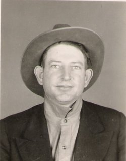
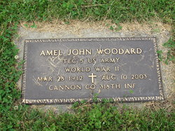

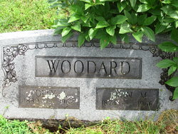
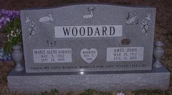
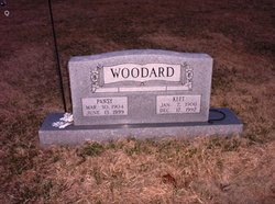
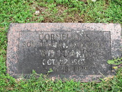
Amel John Woodard
| Birth | : | 28 Mar 1912 McDonald County, Missouri, USA |
| Death | : | 10 Aug 2003 Cassville, Barry County, Missouri, USA |
| Burial | : | Evergreen Cemetery, Grand Forks, Kootenay Boundary Regional District, Canada |
| Coordinate | : | 49.0243650, -118.4520650 |
| Description | : | Son of John & Polly Burnette Woodard. On Nov 5, 1946 he was united in marriage to Mable Cordle. She preceded him in death in Sep. 1999. Amel served his country in the US Army during WW II. He was awarded 3 bronze stars and a Good Conduct Medal. After the war, he lived in Washburn for the rest of his life. He farmed and worked at other various jobs. Survivors include; two sisters, Ola Cooper and Bonnie Winchester, both of Rogers, Ark. He was preceded in death by his parents; two... Read More |
frequently asked questions (FAQ):
-
Where is Amel John Woodard's memorial?
Amel John Woodard's memorial is located at: Evergreen Cemetery, Grand Forks, Kootenay Boundary Regional District, Canada.
-
When did Amel John Woodard death?
Amel John Woodard death on 10 Aug 2003 in Cassville, Barry County, Missouri, USA
-
Where are the coordinates of the Amel John Woodard's memorial?
Latitude: 49.0243650
Longitude: -118.4520650
Family Members:
Parent

Spouse
Siblings

Flowers:


Nearby Cemetories:
1. Evergreen Cemetery
Grand Forks, Kootenay Boundary Regional District, Canada
Coordinate: 49.0243650, -118.4520650
2. Outlook Khristovoye Doukhobor Cemetery
Grand Forks, Kootenay Boundary Regional District, Canada
Coordinate: 49.0402930, -118.4835600
3. USCC Sion Cemetery
Grand Forks, Kootenay Boundary Regional District, Canada
Coordinate: 49.0159500, -118.4964300
4. Danville Cemetery
Ferry County, USA
Coordinate: 48.9885640, -118.5151702
5. Gilpin Cemetery # 1
Gilpin, Kootenay Boundary Regional District, Canada
Coordinate: 49.0090920, -118.3181980
6. Gilpin Cemetery # 2
Gilpin, Kootenay Boundary Regional District, Canada
Coordinate: 49.0084500, -118.3073490
7. Phoenix Cemetery
Greenwood, Kootenay Boundary Regional District, Canada
Coordinate: 49.1019000, -118.6285500
8. Cascade Cemetery
Cascade, Kootenay Boundary Regional District, Canada
Coordinate: 49.0188990, -118.2247300
9. Laurier Cemetery
Ferry County, USA
Coordinate: 48.9855500, -118.2189000
10. Curlew Indian Cemetery
Curlew, Ferry County, USA
Coordinate: 48.8811145, -118.6002982
11. Merritt Pioneer Grave
Curlew, Ferry County, USA
Coordinate: 48.8745300, -118.6020000
12. Curlew City Cemetery
Curlew, Ferry County, USA
Coordinate: 48.8734163, -118.6010599
13. Greenwood Cemetery
Greenwood, Kootenay Boundary Regional District, Canada
Coordinate: 49.1250200, -118.6836000
14. Village of Midway Cemetery
Midway, Kootenay Boundary Regional District, Canada
Coordinate: 49.0082520, -118.7609490
15. Ranald McDonald Cemetery
Toroda, Ferry County, USA
Coordinate: 48.9472094, -118.7617135
16. Somday Family Cemetery
Malo, Ferry County, USA
Coordinate: 48.8290000, -118.5990000
17. Orient Cemetery
Orient, Ferry County, USA
Coordinate: 48.8578987, -118.2032013
18. Eagle Cliff Cemetery
Toroda, Ferry County, USA
Coordinate: 48.9404375, -118.7946296
19. Kelly Hill Cemetery
Stevens County, USA
Coordinate: 48.8130989, -118.1268997
20. Pia Mission Cemetery
Stevens County, USA
Coordinate: 48.7960700, -118.1097300
21. Green Mountain Cemetery
Stevens County, USA
Coordinate: 48.7200180, -118.1178760
22. Bossburg Cemetery
Stevens County, USA
Coordinate: 48.7435989, -118.0485992
23. Thorp Cemetery
Chesaw, Okanogan County, USA
Coordinate: 48.9549900, -119.0316700
24. Chesaw Cemetery
Okanogan County, USA
Coordinate: 48.9299900, -119.0541800