
| Birth | : | 19 Jan 1873 Council Bluffs, Pottawattamie County, Iowa, USA |
| Death | : | 9 May 1902 Pottawattamie County, Iowa, USA |
| Burial | : | Fairview Cemetery, Council Bluffs, Pottawattamie County, USA |
| Coordinate | : | 41.2703018, -95.8480988 |
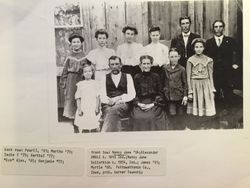
| Description | : | Omaha Daily Bee, May 11, 1902: Council Bluffs News - Mrs. Amy E. Kempster, wife of William Kempster, died yesterday morning at the family residence, in Garner township from tuberculosis, aged 29 years. Her husband and one son survive her. The funeral will be Sunday afternoon at 2:30 o'clock from the family residence and interment will be in Fairview cemetery. The services will be conducted by Rev. W. B. Crewdson, pastor of the Christian church. |
frequently asked questions (FAQ):
-
Where is Amy Elizabeth Umble Kempster's memorial?
Amy Elizabeth Umble Kempster's memorial is located at: Fairview Cemetery, Council Bluffs, Pottawattamie County, USA.
-
When did Amy Elizabeth Umble Kempster death?
Amy Elizabeth Umble Kempster death on 9 May 1902 in Pottawattamie County, Iowa, USA
-
Where are the coordinates of the Amy Elizabeth Umble Kempster's memorial?
Latitude: 41.2703018
Longitude: -95.8480988
Family Members:
Parent

Siblings
Flowers:


Nearby Cemetories:
1. Fairview Cemetery
Council Bluffs, Pottawattamie County, USA
Coordinate: 41.2703018, -95.8480988
2. Ridgewood Cemetery
Council Bluffs, Pottawattamie County, USA
Coordinate: 41.2694016, -95.8272018
3. Walnut Hill Cemetery
Council Bluffs, Pottawattamie County, USA
Coordinate: 41.2719002, -95.8255997
4. Memorial Park Cemetery
Council Bluffs, Pottawattamie County, USA
Coordinate: 41.2644005, -95.8261032
5. Bikhor Cholim Cemetery
Council Bluffs, Pottawattamie County, USA
Coordinate: 41.2703670, -95.8229350
6. Oak Hill Cemetery
Council Bluffs, Pottawattamie County, USA
Coordinate: 41.2700900, -95.8226400
7. Green Valley Cemetery
Council Bluffs, Pottawattamie County, USA
Coordinate: 41.2743988, -95.8225021
8. Saint Joseph Cemetery
Council Bluffs, Pottawattamie County, USA
Coordinate: 41.2722015, -95.8208008
9. Cedar Lawn Cemetery
Council Bluffs, Pottawattamie County, USA
Coordinate: 41.2694016, -95.8182983
10. Clark Cemetery
Pottawattamie County, USA
Coordinate: 41.2551610, -95.8223390
11. Garner Cemetery
Council Bluffs, Pottawattamie County, USA
Coordinate: 41.2956161, -95.8001709
12. Maple Grove Cemetery
Council Bluffs, Pottawattamie County, USA
Coordinate: 41.2265560, -95.8187100
13. Evans Cemetery
Crescent, Pottawattamie County, USA
Coordinate: 41.3255997, -95.8368988
14. Stoker-Graybill Cemetery
Council Bluffs, Pottawattamie County, USA
Coordinate: 41.2532620, -95.7751770
15. Council Point Cemetery
Council Bluffs, Pottawattamie County, USA
Coordinate: 41.2110830, -95.8788610
16. Trinity Cathedral Columbarium
Omaha, Douglas County, USA
Coordinate: 41.2603900, -95.9393660
17. Lewis Township Cemetery
Council Bluffs, Pottawattamie County, USA
Coordinate: 41.2117004, -95.7938995
18. Gregg Cemetery
Weston, Pottawattamie County, USA
Coordinate: 41.3330000, -95.7931000
19. Prospect Hill Cemetery
Omaha, Douglas County, USA
Coordinate: 41.2780991, -95.9593964
20. Hazel Dell Cemetery
Council Bluffs, Pottawattamie County, USA
Coordinate: 41.3489723, -95.7939911
21. First Central Congregational Columbarium
Omaha, Douglas County, USA
Coordinate: 41.2563456, -95.9658365
22. Nash Chapel Crypt
Omaha, Douglas County, USA
Coordinate: 41.2665090, -95.9721790
23. Crescent Cemetery
Crescent, Pottawattamie County, USA
Coordinate: 41.3664894, -95.8566208
24. Douglas County Poor Farm Cemetery
Omaha, Douglas County, USA
Coordinate: 41.2437240, -95.9723480