
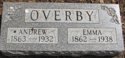
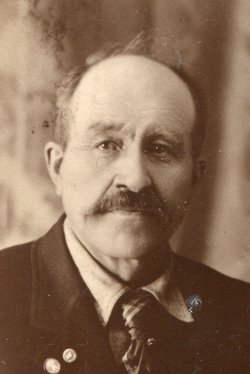

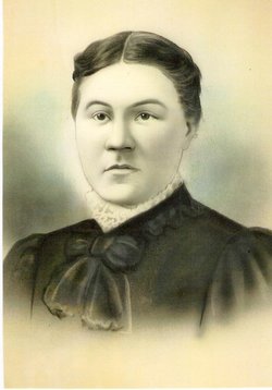
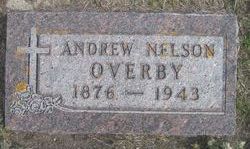
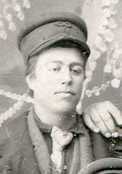
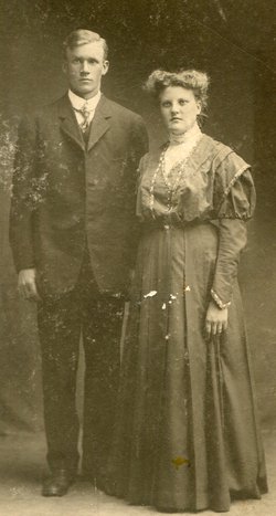
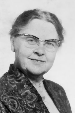
Andrew H. Overby
| Birth | : | 30 Nov 1863 Gjøvik, Gjøvik kommune, Oppland fylke, Norway |
| Death | : | 15 Apr 1932 Binford, Griggs County, North Dakota, USA |
| Burial | : | St. Mary's Churchyard, Brome, Mid Suffolk District, England |
| Coordinate | : | 52.3443800, 1.1475990 |
| Description | : | Andrew Overby. Pioneer Farmer Died Last Friday Andrew H. Overby "Andreas Hanssen", pioneer Griggs County farmer died at his home near Binford last Friday morning shortly before the noon hour after an illness of two weeks from pleurisy which affected his heart. Good recovery had apparently been made from the illness and Mr. Overby had contemplated a trip to town that morning, but his condition suddenly became worse4 and he succombed shortly after eleven o'clock. Funeral services were held on Monday of this week from the hall in Binford. Mr. Youngbeck and Mr. Meyers of Fargo conducted the... Read More |
frequently asked questions (FAQ):
-
Where is Andrew H. Overby's memorial?
Andrew H. Overby's memorial is located at: St. Mary's Churchyard, Brome, Mid Suffolk District, England.
-
When did Andrew H. Overby death?
Andrew H. Overby death on 15 Apr 1932 in Binford, Griggs County, North Dakota, USA
-
Where are the coordinates of the Andrew H. Overby's memorial?
Latitude: 52.3443800
Longitude: 1.1475990
Family Members:
Parent
Spouse

Siblings

Children
Flowers:


Nearby Cemetories:
1. St. Mary's Churchyard
Brome, Mid Suffolk District, England
Coordinate: 52.3443800, 1.1475990
2. St. Nicholas Churchyard
Oakley, Mid Suffolk District, England
Coordinate: 52.3518380, 1.1662190
3. All Saints Churchyard
Stuston, Mid Suffolk District, England
Coordinate: 52.3571980, 1.1332590
4. Eye War Memorial
Eye, Mid Suffolk District, England
Coordinate: 52.3213410, 1.1461480
5. Saint Andrew Churchyard
Scole, South Norfolk District, England
Coordinate: 52.3671670, 1.1579150
6. Saint Peter and Saint Paul Churchyard
Eye, Mid Suffolk District, England
Coordinate: 52.3200520, 1.1516450
7. Eye Cemetery
Eye, Mid Suffolk District, England
Coordinate: 52.3188270, 1.1371000
8. St Leonard Churchyard
Billingford, South Norfolk District, England
Coordinate: 52.3666290, 1.1834260
9. St Peter Churchyard
Palgrave, Mid Suffolk District, England
Coordinate: 52.3634190, 1.1059170
10. Saint Peter and St. Paul Churchyard
Hoxne, Mid Suffolk District, England
Coordinate: 52.3522270, 1.2016300
11. Unitarian Chapel Cemetery
Palgrave, Mid Suffolk District, England
Coordinate: 52.3693130, 1.1086820
12. St Andrew's Frenze Church
Scole, South Norfolk District, England
Coordinate: 52.3802000, 1.1361000
13. Saint Mary Churchyard
Diss, South Norfolk District, England
Coordinate: 52.3772370, 1.1097880
14. Diss War Memorial
Diss, South Norfolk District, England
Coordinate: 52.3773380, 1.1088530
15. Saint John The Baptist Churchyard
Denham, Mid Suffolk District, England
Coordinate: 52.3275300, 1.2101200
16. Croft Lane Baptist Church Burial Ground
Diss, South Norfolk District, England
Coordinate: 52.3771070, 1.1025490
17. St Mary's Church Burial Ground - old
Braiseworth, Mid Suffolk District, England
Coordinate: 52.3028860, 1.1277010
18. Braiseworth War Memorial
Braiseworth, Mid Suffolk District, England
Coordinate: 52.3027890, 1.1276970
19. Diss Cemetery
Diss, South Norfolk District, England
Coordinate: 52.3839060, 1.1115880
20. St Mary Churchyard
Thornham Parva, Mid Suffolk District, England
Coordinate: 52.3113910, 1.0926010
21. St Mary the Virgin Churchyard
Mellis, Mid Suffolk District, England
Coordinate: 52.3268950, 1.0725720
22. St. Michael's Churchyard
Occold, Mid Suffolk District, England
Coordinate: 52.2936170, 1.1598150
23. St. Remigius Churchyard
Roydon, South Norfolk District, England
Coordinate: 52.3815610, 1.0784680
24. Saint George Churchyard
Shimpling, South Norfolk District, England
Coordinate: 52.3993000, 1.1680000