
| Birth | : | 1838 Chesterfield County, South Carolina, USA |
| Death | : | unknown Chesterfield County, South Carolina, USA |
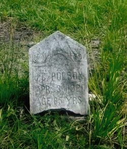
| Burial | : | Ainsley Polson Cemetery, Patrick, Chesterfield County, USA |
| Coordinate | : | 34.5858600, -80.0204810 |
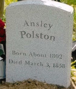
| Description | : | Ann Eliza's parents were Ainsley Polson and Mary Jane Crowley. No marker exists for her. |
frequently asked questions (FAQ):
-
Where is Ann Eliza Polson's memorial?
Ann Eliza Polson's memorial is located at: Ainsley Polson Cemetery, Patrick, Chesterfield County, USA.
-
When did Ann Eliza Polson death?
Ann Eliza Polson death on unknown in Chesterfield County, South Carolina, USA
-
Where are the coordinates of the Ann Eliza Polson's memorial?
Latitude: 34.5858600
Longitude: -80.0204810
Family Members:
Parent

Siblings
Flowers:


Nearby Cemetories:
1. Ainsley Polson Cemetery
Patrick, Chesterfield County, USA
Coordinate: 34.5858600, -80.0204810
2. Mount Olive Church Cemetery
Patrick, Chesterfield County, USA
Coordinate: 34.5808400, -80.0330600
3. Morning Star Baptist Church Cemetery
Patrick, Chesterfield County, USA
Coordinate: 34.5772100, -80.0437200
4. Saint Marys Presbyterian Church Cemetery Old
Patrick, Chesterfield County, USA
Coordinate: 34.5989460, -80.0001400
5. Polson Cemetery
Patrick, Chesterfield County, USA
Coordinate: 34.5778480, -80.0467570
6. Griggs Cemetery
Patrick, Chesterfield County, USA
Coordinate: 34.5602630, -80.0050000
7. Patrick Cemetery
Patrick, Chesterfield County, USA
Coordinate: 34.5746994, -80.0567017
8. Piney Grove Cemetery
Cheraw, Chesterfield County, USA
Coordinate: 34.5825000, -79.9705600
9. Pierce Cemetery
Patrick, Chesterfield County, USA
Coordinate: 34.6184529, -80.0608026
10. Piney Grove Baptist Church Cemetery
Patrick, Chesterfield County, USA
Coordinate: 34.6144500, -79.9728500
11. Brown Springs Baptist Church Cemetery
Patrick, Chesterfield County, USA
Coordinate: 34.5373690, -80.0374550
12. Fannie Cemetery
Chesterfield County, USA
Coordinate: 34.6352997, -80.0541992
13. Huggins-McLain Cemetery
Patrick, Chesterfield County, USA
Coordinate: 34.5917015, -80.0924988
14. Bethesda United Methodist Church Cemetery
Chesterfield, Chesterfield County, USA
Coordinate: 34.6422005, -80.0468979
15. Mount Mary Baptist Church Cemetery
Chesterfield, Chesterfield County, USA
Coordinate: 34.6463050, -80.0383590
16. Curry Family Cemetery
Chesterfield, Chesterfield County, USA
Coordinate: 34.6478430, -80.0053170
17. Bear Creek Cemetery
Patrick, Chesterfield County, USA
Coordinate: 34.6122300, -80.0918340
18. Green Family Cemetery
Chesterfield, Chesterfield County, USA
Coordinate: 34.6514260, -80.0319670
19. Pleasant Hill Baptist Church Cemetery
Cheraw, Chesterfield County, USA
Coordinate: 34.6372990, -79.9684310
20. Forest Pine Freewill Independent Church Cemetery
Cheraw, Chesterfield County, USA
Coordinate: 34.6324050, -79.9585820
21. Cross Branch Cemetery
Chesterfield County, USA
Coordinate: 34.6324997, -80.0836029
22. Edwards Chapel Baptist Church Cemetery
Chesterfield County, USA
Coordinate: 34.5274160, -79.9591850
23. Mount Olivet United Methodist Church Cemetery
Hunts Mill, Chesterfield County, USA
Coordinate: 34.6623192, -79.9972763
24. Saint John Freewill Baptist Church Cemetery
Chesterfield County, USA
Coordinate: 34.6128000, -80.1111000