
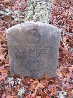
| Birth | : | 1841 Chesterfield County, South Carolina, USA |
| Death | : | 25 Nov 1896 Hartsville, Darlington County, South Carolina, USA |
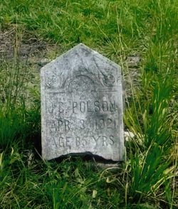
| Burial | : | Ainsley Polson Cemetery, Patrick, Chesterfield County, USA |
| Coordinate | : | 34.5858600, -80.0204810 |
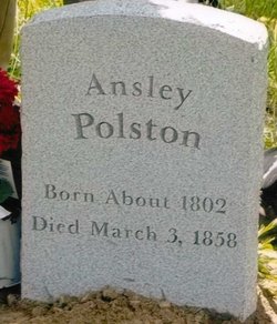
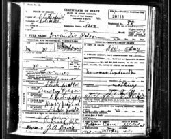
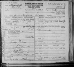
| Description | : | I've seen the middle initial "W" in David's name in his obituary and in land deeds but do not know what it stood for. His parents were Ainsley and Mary Jane Crowley Polson. "Mr. D.W. Polson died at his home, near Hartsville Nov. 25th 1896. His remains were taken to Chesterfield county for burial. A wife and several children are left to mourn his death" (source: Polson Family folder at the Darlington Historical Commission in Darlington, SC) |
frequently asked questions (FAQ):
-
Where is David W. Polson's memorial?
David W. Polson's memorial is located at: Ainsley Polson Cemetery, Patrick, Chesterfield County, USA.
-
When did David W. Polson death?
David W. Polson death on 25 Nov 1896 in Hartsville, Darlington County, South Carolina, USA
-
Where are the coordinates of the David W. Polson's memorial?
Latitude: 34.5858600
Longitude: -80.0204810
Family Members:
Parent

Spouse
Siblings
Children
Flowers:


Nearby Cemetories:
1. Ainsley Polson Cemetery
Patrick, Chesterfield County, USA
Coordinate: 34.5858600, -80.0204810
2. Mount Olive Church Cemetery
Patrick, Chesterfield County, USA
Coordinate: 34.5808400, -80.0330600
3. Morning Star Baptist Church Cemetery
Patrick, Chesterfield County, USA
Coordinate: 34.5772100, -80.0437200
4. Saint Marys Presbyterian Church Cemetery Old
Patrick, Chesterfield County, USA
Coordinate: 34.5989460, -80.0001400
5. Polson Cemetery
Patrick, Chesterfield County, USA
Coordinate: 34.5778480, -80.0467570
6. Griggs Cemetery
Patrick, Chesterfield County, USA
Coordinate: 34.5602630, -80.0050000
7. Patrick Cemetery
Patrick, Chesterfield County, USA
Coordinate: 34.5746994, -80.0567017
8. Piney Grove Cemetery
Cheraw, Chesterfield County, USA
Coordinate: 34.5825000, -79.9705600
9. Pierce Cemetery
Patrick, Chesterfield County, USA
Coordinate: 34.6184529, -80.0608026
10. Piney Grove Baptist Church Cemetery
Patrick, Chesterfield County, USA
Coordinate: 34.6144500, -79.9728500
11. Brown Springs Baptist Church Cemetery
Patrick, Chesterfield County, USA
Coordinate: 34.5373690, -80.0374550
12. Fannie Cemetery
Chesterfield County, USA
Coordinate: 34.6352997, -80.0541992
13. Huggins-McLain Cemetery
Patrick, Chesterfield County, USA
Coordinate: 34.5917015, -80.0924988
14. Bethesda United Methodist Church Cemetery
Chesterfield, Chesterfield County, USA
Coordinate: 34.6422005, -80.0468979
15. Mount Mary Baptist Church Cemetery
Chesterfield, Chesterfield County, USA
Coordinate: 34.6463050, -80.0383590
16. Curry Family Cemetery
Chesterfield, Chesterfield County, USA
Coordinate: 34.6478430, -80.0053170
17. Bear Creek Cemetery
Patrick, Chesterfield County, USA
Coordinate: 34.6122300, -80.0918340
18. Green Family Cemetery
Chesterfield, Chesterfield County, USA
Coordinate: 34.6514260, -80.0319670
19. Pleasant Hill Baptist Church Cemetery
Cheraw, Chesterfield County, USA
Coordinate: 34.6372990, -79.9684310
20. Forest Pine Freewill Independent Church Cemetery
Cheraw, Chesterfield County, USA
Coordinate: 34.6324050, -79.9585820
21. Cross Branch Cemetery
Chesterfield County, USA
Coordinate: 34.6324997, -80.0836029
22. Edwards Chapel Baptist Church Cemetery
Chesterfield County, USA
Coordinate: 34.5274160, -79.9591850
23. Mount Olivet United Methodist Church Cemetery
Hunts Mill, Chesterfield County, USA
Coordinate: 34.6623192, -79.9972763
24. Saint John Freewill Baptist Church Cemetery
Chesterfield County, USA
Coordinate: 34.6128000, -80.1111000