
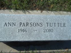
Ann Parsons Tuttle
| Birth | : | 24 May 1916 |
| Death | : | 14 Apr 2010 |
| Burial | : | Wollaton Cemetery, Wollaton, Nottingham Unitary Authority, England |
| Coordinate | : | 52.9503000, -1.2260800 |
| Description | : | Ann Parsons Tuttle, 93, quietly passed away in Hartley on April 14, 1916, after a lengthy battle with Alzheimer's disease. The daughter of Carl and Adelia Parsons, Ann grew up in Spirit Lake, along with her brothers Carl Jr., John, Rod and Carlisle. After high school she moved to Spencer, where she married Frank Tuttle in 1942. Ann was a highly creative and artistic woman; a lifelong learner. She taught art classes for the YMCA and at her 'Decorator's Workshop; in downtown Spencer. She always had many creative projects going at once; sewing, knitting, crocheting, ceramics, jewelry making, and even building... Read More |
frequently asked questions (FAQ):
-
Where is Ann Parsons Tuttle's memorial?
Ann Parsons Tuttle's memorial is located at: Wollaton Cemetery, Wollaton, Nottingham Unitary Authority, England.
-
When did Ann Parsons Tuttle death?
Ann Parsons Tuttle death on 14 Apr 2010 in
-
Where are the coordinates of the Ann Parsons Tuttle's memorial?
Latitude: 52.9503000
Longitude: -1.2260800
Family Members:
Parent

Spouse
Children

Flowers:


Nearby Cemetories:
1. St. Leonard's Churchyard
Wollaton, Nottingham Unitary Authority, England
Coordinate: 52.9529790, -1.2200830
2. Beeston Cemetery
Beeston, Broxtowe Borough, England
Coordinate: 52.9354540, -1.2275310
3. Bramcote Crematorium
Beeston, Broxtowe Borough, England
Coordinate: 52.9456300, -1.2555100
4. St. Michael and All Angels Churchyard
Bramcote, Broxtowe Borough, England
Coordinate: 52.9352531, -1.2463690
5. St. John the Baptist Churchyard
Beeston, Broxtowe Borough, England
Coordinate: 52.9255562, -1.2167680
6. All Saints Church
Strelley, Broxtowe Borough, England
Coordinate: 52.9737900, -1.2470340
7. Beeston Baptist Chapel
Beeston, Broxtowe Borough, England
Coordinate: 52.9246600, -1.2122000
8. St. Peter Churchyard Old Radford
Nottingham, Nottingham Unitary Authority, England
Coordinate: 52.9601830, -1.1789620
9. Holy Trinity Churchyard
Lenton, Nottingham Unitary Authority, England
Coordinate: 52.9485630, -1.1753148
10. Stapleford Cemetery
Stapleford, Broxtowe Borough, England
Coordinate: 52.9299770, -1.2699190
11. St. Helen's Churchyard
Trowell, Broxtowe Borough, England
Coordinate: 52.9528120, -1.2815590
12. St. Helen's Churchyard
Stapleford, Broxtowe Borough, England
Coordinate: 52.9316670, -1.2744440
13. Chilwell Cemetery
Nottingham, Nottingham Unitary Authority, England
Coordinate: 52.9164070, -1.2430800
14. Hardy Street Jewish Cemetery
Nottingham, Nottingham Unitary Authority, England
Coordinate: 52.9619500, -1.1665900
15. General Cemetery
Nottingham, Nottingham Unitary Authority, England
Coordinate: 52.9561430, -1.1615420
16. Nottingham General Cemetery
Nottingham, Nottingham Unitary Authority, England
Coordinate: 52.9575370, -1.1594236
17. St. Leodegarius Churchyard
Old Basford, Nottingham Unitary Authority, England
Coordinate: 52.9794240, -1.1778650
18. Cathedral Church of St. Barnabas
Nottingham, Nottingham Unitary Authority, England
Coordinate: 52.9546750, -1.1570460
19. St. Wilfrid Churchyard
Wilford, Nottingham Unitary Authority, England
Coordinate: 52.9346290, -1.1587770
20. Wilford Village Cemetery
Wilford, Nottingham Unitary Authority, England
Coordinate: 52.9338540, -1.1591170
21. Basford Cemetery
Old Basford, Nottingham Unitary Authority, England
Coordinate: 52.9799700, -1.1725900
22. Nottingham Church Cemetery
Nottingham, Nottingham Unitary Authority, England
Coordinate: 52.9649830, -1.1558070
23. St Nicholas Churchyard
Nottingham, Nottingham Unitary Authority, England
Coordinate: 52.9504780, -1.1509220
24. St Mary's Churchyard
Clifton, Nottingham Unitary Authority, England
Coordinate: 52.9083870, -1.1965435