
| Birth | : | 28 Sep 1921 |
| Death | : | 7 Jun 2004 |
| Burial | : | Manly Cemetery, Manly, Northern Beaches Council, Australia |
| Coordinate | : | -33.7922700, 151.2715000 |
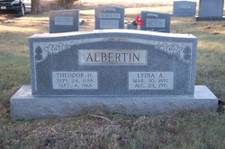
| Description | : | Anna Cook, 82, California, Mo., died in Jesus on Monday, June 7, 2004 at her home in California, Mo. She was born on September 28, 1921 in Moniteau County, Mo., the daughter of Theodore and Lydia Baade Albertin who preceded her in death. She was married on June 13, 1948 in California, Mo., to Elwood Cook who survives of the home. She graduated from California High School in 1940 and from Central Missouri State University in Warrensburg in 1947. She taught her first five years in the Johnson and Sunnyside rural schools before teaching fourth grade in the California system for six... Read More |
frequently asked questions (FAQ):
-
Where is Anna Albertin Cook's memorial?
Anna Albertin Cook's memorial is located at: Manly Cemetery, Manly, Northern Beaches Council, Australia.
-
When did Anna Albertin Cook death?
Anna Albertin Cook death on 7 Jun 2004 in
-
Where are the coordinates of the Anna Albertin Cook's memorial?
Latitude: -33.7922700
Longitude: 151.2715000
Family Members:
Parent

Spouse
Siblings
Flowers:


Nearby Cemetories:
1. Sydney North Head Quarantine Cemetery
Manly, Northern Beaches Council, Australia
Coordinate: -33.8177130, 151.2947000
2. Rawson Park
Mosman, Mosman Municipality, Australia
Coordinate: -33.8350640, 151.2504980
3. St. Thomas Rest Park
Crows Nest, North Sydney Council, Australia
Coordinate: -33.8244490, 151.2063050
4. Mary MacKillop Memorial Chapel
North Sydney, North Sydney Council, Australia
Coordinate: -33.8388250, 151.2049160
5. Gore Hill Cemetery
St Leonards, North Sydney Council, Australia
Coordinate: -33.8229500, 151.1887590
6. Garden Island
Potts Point, City of Sydney, Australia
Coordinate: -33.8613635, 151.2280308
7. Frenchs Forest Cemetery
Davidson, Northern Beaches Council, Australia
Coordinate: -33.7392360, 151.2020750
8. Royal Botanic Gardens
Sydney, City of Sydney, Australia
Coordinate: -33.8647440, 151.2170610
9. St Aidan's Anglican Church
Longueville, Lane Cove Municipality, Australia
Coordinate: -33.8281510, 151.1709560
10. Parish Church of Saint James
Sydney, City of Sydney, Australia
Coordinate: -33.8693760, 151.2111540
11. Saint Mary's Cathedral
Sydney, City of Sydney, Australia
Coordinate: -33.8708540, 151.2135820
12. Old Sydney Burial Ground
Sydney, City of Sydney, Australia
Coordinate: -33.8731750, 151.2063850
13. Northern Suburbs Memorial Gardens and Crematorium
North Ryde, Ryde City, Australia
Coordinate: -33.7954460, 151.1511550
14. Devonshire Street Cemetery (Defunct)
Sydney, City of Sydney, Australia
Coordinate: -33.8828080, 151.2066180
15. St. John's Anglican Church Cemetery
Gordon, Ku-ring-gai Council, Australia
Coordinate: -33.7571060, 151.1519580
16. Church of St. Francis and St. Alban
Gordon, Ku-ring-gai Council, Australia
Coordinate: -33.7563700, 151.1522220
17. Macquarie Park Cemetery and Crematorium
North Ryde, Ryde City, Australia
Coordinate: -33.7937180, 151.1420060
18. Mona Vale Cemetery
Mona Vale, Northern Beaches Council, Australia
Coordinate: -33.6752140, 151.2879720
19. Mona Vale Anglican Church
Mona Vale, Northern Beaches Council, Australia
Coordinate: -33.6745924, 151.3031547
20. Saint Jude's Cemetery
Randwick, Randwick City, Australia
Coordinate: -33.9115460, 151.2417130
21. Gladesville Asylum Cemetery
Gladesville, Hunter's Hill Municipality, Australia
Coordinate: -33.8393010, 151.1342490
22. Field of Mars Cemetery
East Ryde, Ryde City, Australia
Coordinate: -33.8120030, 151.1246480
23. Camperdown Cemetery
Newtown, City of Sydney, Australia
Coordinate: -33.8942220, 151.1804900
24. Pioneers Memorial Park
Leichhardt, Inner West Council, Australia
Coordinate: -33.8780800, 151.1575000