


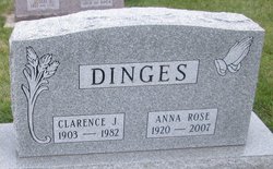
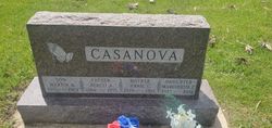
Anna Rose Casanova Dinges
| Birth | : | 16 Dec 1920 Lake County, South Dakota, USA |
| Death | : | 24 Aug 2007 Sioux Falls, Minnehaha County, South Dakota, USA |
| Burial | : | Fairview Cemetery, Council Bluffs, Pottawattamie County, USA |
| Coordinate | : | 41.2703018, -95.8480988 |
| Description | : | Mass of Christian Burial will be Tues., Aug. 28, for Anna Rose Dinges, 86, Ramona, who died on Aug. 24, 2007, at Avera McKennan Hospital. The Rev. Michael Schneider will officiate in St. Williams Catholic Church at Ramona, and burial will be in the church cemetery. Anna Rose Casanova was born on Dec. 16, 1920, in Lake County to Hercli and Annie (Giossi) Casanova. She grew up in Ramona, where she graduated from Ramona High School. She received a teaching certificate from Eastern State Normal School and taught school before she was married. She married Milo Mathison on Jan. 10, 1942; he... Read More |
frequently asked questions (FAQ):
-
Where is Anna Rose Casanova Dinges's memorial?
Anna Rose Casanova Dinges's memorial is located at: Fairview Cemetery, Council Bluffs, Pottawattamie County, USA.
-
When did Anna Rose Casanova Dinges death?
Anna Rose Casanova Dinges death on 24 Aug 2007 in Sioux Falls, Minnehaha County, South Dakota, USA
-
Where are the coordinates of the Anna Rose Casanova Dinges's memorial?
Latitude: 41.2703018
Longitude: -95.8480988
Family Members:
Parent

Spouse

Siblings
Children

Flowers:


Nearby Cemetories:
1. Fairview Cemetery
Council Bluffs, Pottawattamie County, USA
Coordinate: 41.2703018, -95.8480988
2. Ridgewood Cemetery
Council Bluffs, Pottawattamie County, USA
Coordinate: 41.2694016, -95.8272018
3. Walnut Hill Cemetery
Council Bluffs, Pottawattamie County, USA
Coordinate: 41.2719002, -95.8255997
4. Memorial Park Cemetery
Council Bluffs, Pottawattamie County, USA
Coordinate: 41.2644005, -95.8261032
5. Bikhor Cholim Cemetery
Council Bluffs, Pottawattamie County, USA
Coordinate: 41.2703670, -95.8229350
6. Oak Hill Cemetery
Council Bluffs, Pottawattamie County, USA
Coordinate: 41.2700900, -95.8226400
7. Green Valley Cemetery
Council Bluffs, Pottawattamie County, USA
Coordinate: 41.2743988, -95.8225021
8. Saint Joseph Cemetery
Council Bluffs, Pottawattamie County, USA
Coordinate: 41.2722015, -95.8208008
9. Cedar Lawn Cemetery
Council Bluffs, Pottawattamie County, USA
Coordinate: 41.2694016, -95.8182983
10. Clark Cemetery
Pottawattamie County, USA
Coordinate: 41.2551610, -95.8223390
11. Garner Cemetery
Council Bluffs, Pottawattamie County, USA
Coordinate: 41.2956161, -95.8001709
12. Maple Grove Cemetery
Council Bluffs, Pottawattamie County, USA
Coordinate: 41.2265560, -95.8187100
13. Evans Cemetery
Crescent, Pottawattamie County, USA
Coordinate: 41.3255997, -95.8368988
14. Stoker-Graybill Cemetery
Council Bluffs, Pottawattamie County, USA
Coordinate: 41.2532620, -95.7751770
15. Council Point Cemetery
Council Bluffs, Pottawattamie County, USA
Coordinate: 41.2110830, -95.8788610
16. Trinity Cathedral Columbarium
Omaha, Douglas County, USA
Coordinate: 41.2603900, -95.9393660
17. Lewis Township Cemetery
Council Bluffs, Pottawattamie County, USA
Coordinate: 41.2117004, -95.7938995
18. Gregg Cemetery
Weston, Pottawattamie County, USA
Coordinate: 41.3330000, -95.7931000
19. Prospect Hill Cemetery
Omaha, Douglas County, USA
Coordinate: 41.2780991, -95.9593964
20. Hazel Dell Cemetery
Council Bluffs, Pottawattamie County, USA
Coordinate: 41.3489723, -95.7939911
21. First Central Congregational Columbarium
Omaha, Douglas County, USA
Coordinate: 41.2563456, -95.9658365
22. Nash Chapel Crypt
Omaha, Douglas County, USA
Coordinate: 41.2665090, -95.9721790
23. Crescent Cemetery
Crescent, Pottawattamie County, USA
Coordinate: 41.3664894, -95.8566208
24. Douglas County Poor Farm Cemetery
Omaha, Douglas County, USA
Coordinate: 41.2437240, -95.9723480