
Annie May Allan Millar
| Birth | : | 1877 |
| Death | : | 1963 |
| Burial | : | Kirkhart-King Cemetery, Roane County, USA |
| Coordinate | : | 38.5721090, -81.2053050 |
| Plot | : | 25 |
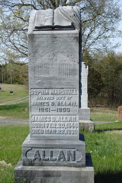
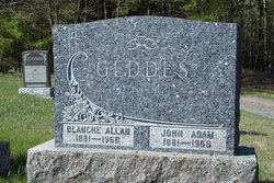
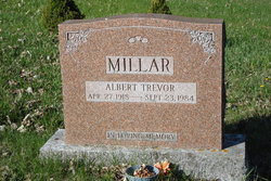
| Description | : | Daughter of James Duncan Allan and Sophia Marshall. She married John Duncan Millar 1874-1937. -------------------------------------- Marriage - The Lanark Era - Dec.7,1898 - At Allen's Mills, (McLaren's Depot), November 30th, Miss Annie Allen, daughter of Mr. Jas. Allen, was wed to Mr. John D. Miller, also of that place. The bride's sister, Miss Blanche Allen, assisted. Among the guests were Mrs. A. Stewart and Mr. R.A. Duncan also of McLaren's Depot. -------------------------------------- Plot 25 : - John D. Millar, 1874-1937, - his wife, Annie May Allan, 1877-1963. |
frequently asked questions (FAQ):
-
Where is Annie May Allan Millar's memorial?
Annie May Allan Millar's memorial is located at: Kirkhart-King Cemetery, Roane County, USA.
-
When did Annie May Allan Millar death?
Annie May Allan Millar death on 1963 in
-
Where are the coordinates of the Annie May Allan Millar's memorial?
Latitude: 38.5721090
Longitude: -81.2053050
Family Members:
Parent

Spouse
Siblings
Children

Flowers:


Nearby Cemetories:
1. Kirkhart-King Cemetery
Roane County, USA
Coordinate: 38.5721090, -81.2053050
2. O'Dell Cemetery
Amma, Roane County, USA
Coordinate: 38.5540490, -81.2366440
3. Hill Cemetery
Amma, Roane County, USA
Coordinate: 38.5359890, -81.1981760
4. Cook Cemetery
Roane County, USA
Coordinate: 38.5852800, -81.2527010
5. Reed Cemetery
Amma, Roane County, USA
Coordinate: 38.5614014, -81.2608032
6. Amma Cemetery
Amma, Roane County, USA
Coordinate: 38.5660190, -81.2670710
7. Knight Cemetery
Roane County, USA
Coordinate: 38.6099170, -81.2476170
8. Alkanah Carper Cemetery
Roane County, USA
Coordinate: 38.6063995, -81.2544022
9. Hall Cemetery
Clay County, USA
Coordinate: 38.5311012, -81.1605988
10. Ashley Cemetery
Clio, Roane County, USA
Coordinate: 38.5728930, -81.2831610
11. Ashley Waitman Cemetery
Amma, Roane County, USA
Coordinate: 38.5727997, -81.2835999
12. Belcher Cemetery
Ovapa, Clay County, USA
Coordinate: 38.5260640, -81.1519610
13. Hively Cemetery
Clay County, USA
Coordinate: 38.5388985, -81.1343994
14. Ovapa Church of God Cemetery
Ovapa, Clay County, USA
Coordinate: 38.5259680, -81.1470270
15. Wyant Cemetery
Ovapa, Clay County, USA
Coordinate: 38.5161770, -81.1569900
16. Adkins Family Cemetery
Roane County, USA
Coordinate: 38.5238991, -81.2718964
17. Payne Cemetery
Clio, Roane County, USA
Coordinate: 38.5891991, -81.2957993
18. Jarvis Cemetery
Left Hand, Roane County, USA
Coordinate: 38.6476640, -81.2186470
19. Groves Cemetery
Roane County, USA
Coordinate: 38.6081000, -81.2964000
20. Procious Cemetery
Procious, Clay County, USA
Coordinate: 38.4928080, -81.1939270
21. George Groves Cemetery
Left Hand, Roane County, USA
Coordinate: 38.6083861, -81.2963389
22. Armstead Cemetery #3
Clio, Roane County, USA
Coordinate: 38.5694800, -81.3097500
23. Foreman Cemetery
Procious, Clay County, USA
Coordinate: 38.4935660, -81.2351740
24. Samples Harvey Cemetery
Procious, Clay County, USA
Coordinate: 38.4900060, -81.2049670