
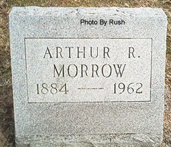
Arthur Richard Morrow
| Birth | : | 8 Nov 1884 La Salle, LaSalle County, Illinois, USA |
| Death | : | 15 Mar 1962 Logansport, Cass County, Indiana, USA |
| Burial | : | Scotforth Cemetery, Scotforth, City of Lancaster, England |
| Coordinate | : | 54.0282250, -2.8007170 |
| Description | : | Arthur R. Morrow, Thornhope, Dies Arthur Richard Morrow, 77, of Thornhop'e, died at 12:15 a.m. Thursday at Memorial hospital. An antique dealer in Thornhope, he had retired in 1947 after serving 45 years with the Chicago American as a photo-engraver. He was born Nov. 8, 1884, in La- Salle, Ill., the son of Chris and Hannah Roberts Morrow. He was never married and is survived by two nephews and a niece living in Chicago. The deceased was a member of the Chicago Photo Engravers union. Final rites will be at 1 p.m. Saturday at the Harrison Garden Chapel in Royal Center. Burial will be in Buck cemetery. Pulaski county. Friends may call at the funeral home after 7 p.m. Thursday. Logansport, Indiana, Pharos-Tribune Thursday Evening, March... Read More |
frequently asked questions (FAQ):
-
Where is Arthur Richard Morrow's memorial?
Arthur Richard Morrow's memorial is located at: Scotforth Cemetery, Scotforth, City of Lancaster, England.
-
When did Arthur Richard Morrow death?
Arthur Richard Morrow death on 15 Mar 1962 in Logansport, Cass County, Indiana, USA
-
Where are the coordinates of the Arthur Richard Morrow's memorial?
Latitude: 54.0282250
Longitude: -2.8007170
Family Members:
Parent
Flowers:


Nearby Cemetories:
1. Scotforth Cemetery
Scotforth, City of Lancaster, England
Coordinate: 54.0282250, -2.8007170
2. Mount Street Congregational Chapel
Lancaster, City of Lancaster, England
Coordinate: 54.0468260, -2.8027430
3. Cathedral Cemetery of Lancaster
Lancaster, City of Lancaster, England
Coordinate: 54.0471170, -2.7942920
4. Friends Meeting House Burial Ground
Lancaster, City of Lancaster, England
Coordinate: 54.0482500, -2.8058025
5. St. Nicholas Street Chapel Churchyard
Lancaster, City of Lancaster, England
Coordinate: 54.0486900, -2.7987900
6. Lancaster Castle Cemetery
Lancaster, City of Lancaster, England
Coordinate: 54.0494330, -2.8047890
7. St. John the Evangelist Churchyard
Lancaster, City of Lancaster, England
Coordinate: 54.0504000, -2.7990000
8. Lancaster Priory
Lancaster, City of Lancaster, England
Coordinate: 54.0507360, -2.8057850
9. Lancaster Cemetery
Lancaster, City of Lancaster, England
Coordinate: 54.0504210, -2.7768760
10. Saint Luke's Parish Churchyard
Skerton, City of Lancaster, England
Coordinate: 54.0564700, -2.7982600
11. St John’s Church Graveyard
Ellel, City of Lancaster, England
Coordinate: 53.9990010, -2.7846660
12. St. Helen's Churchyard
Overton, City of Lancaster, England
Coordinate: 54.0111620, -2.8552950
13. Skerton Cemetery
Lancaster, City of Lancaster, England
Coordinate: 54.0651430, -2.7951140
14. Quernmore Methodist Churchyard
Quernmore, City of Lancaster, England
Coordinate: 54.0259440, -2.7361400
15. St Peter's Churchyard
Quernmore, City of Lancaster, England
Coordinate: 54.0367200, -2.7375400
16. Lancaster and Morecambe Crematorium
Lancaster, City of Lancaster, England
Coordinate: 54.0650890, -2.8198420
17. Christ Church of Glasson Churchyard
Glasson, City of Lancaster, England
Coordinate: 53.9966870, -2.8421460
18. Torrisholme Cemetery
Morecambe, City of Lancaster, England
Coordinate: 54.0638980, -2.8409800
19. St Thomas with Elizabeth Churchyard
Thurnham, City of Lancaster, England
Coordinate: 53.9819990, -2.8159520
20. St Wilfrid's Churchyard
Halton, City of Lancaster, England
Coordinate: 54.0759400, -2.7672600
21. St. Mary's Chapel Ellel Grange
Ellel, City of Lancaster, England
Coordinate: 53.9756944, -2.7918522
22. Hale Carr Lane Cemetery
Morecambe, City of Lancaster, England
Coordinate: 54.0520500, -2.8833940
23. Holy Trinity Church Poulton-le-Sands
Morecambe, City of Lancaster, England
Coordinate: 54.0744769, -2.8569331
24. Morecambe Cemetery
Morecambe, City of Lancaster, England
Coordinate: 54.0759090, -2.8572610