
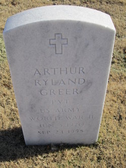
Arthur Ryland Greer
| Birth | : | 3 Jun 1920 |
| Death | : | 24 Sep 1995 |
| Burial | : | St. Michael Churchyard, Mottram in Longdendale, Metropolitan Borough of Tameside, England |
| Coordinate | : | 53.4544040, -2.0101460 |
| Plot | : | I, 0, 437 |
frequently asked questions (FAQ):
-
Where is Arthur Ryland Greer's memorial?
Arthur Ryland Greer's memorial is located at: St. Michael Churchyard, Mottram in Longdendale, Metropolitan Borough of Tameside, England.
-
When did Arthur Ryland Greer death?
Arthur Ryland Greer death on 24 Sep 1995 in
-
Where are the coordinates of the Arthur Ryland Greer's memorial?
Latitude: 53.4544040
Longitude: -2.0101460
Family Members:
Parent
Spouse
Siblings
Children
Flowers:


Nearby Cemetories:
1. Mottram Cemetery
Mottram in Longdendale, Metropolitan Borough of Tameside, England
Coordinate: 53.4546420, -2.0086900
2. Hollingworth United Methodist Cemetery
Hollingworth, Metropolitan Borough of Tameside, England
Coordinate: 53.4632891, -1.9958244
3. St. John the Evangelist Churchyard
Charlesworth, High Peak Borough, England
Coordinate: 53.4327430, -1.9945570
4. St. Mary's Independent Chapel
Charlesworth, High Peak Borough, England
Coordinate: 53.4317127, -1.9856703
5. Tintwistle Churchyard
Tintwistle, High Peak Borough, England
Coordinate: 53.4719150, -1.9685915
6. St Mary's Churchyard
Hyde, Metropolitan Borough of Tameside, England
Coordinate: 53.4652400, -2.0599700
7. United Reformed Church
Tintwistle, High Peak Borough, England
Coordinate: 53.4729900, -1.9657910
8. St. John The Baptist Churchyard
Hyde, Metropolitan Borough of Tameside, England
Coordinate: 53.4548411, -2.0644712
9. Glossop Cemetery
Glossop, High Peak Borough, England
Coordinate: 53.4573090, -1.9506990
10. Holy Trinity Churchyard
Gee Cross, Metropolitan Borough of Tameside, England
Coordinate: 53.4393900, -2.0645500
11. Saint Thomas The Apostle Churchyard
Hyde, Metropolitan Borough of Tameside, England
Coordinate: 53.4509000, -2.0707000
12. Hyde Cemetery
Hyde, Metropolitan Borough of Tameside, England
Coordinate: 53.4437910, -2.0684130
13. St Paul Churchyard
Stalybridge, Metropolitan Borough of Tameside, England
Coordinate: 53.4852000, -2.0440300
14. Saint James Churchyard
Whitfield, High Peak Borough, England
Coordinate: 53.4388640, -1.9529100
15. Littlemoor Chapel
Glossop, High Peak Borough, England
Coordinate: 53.4412869, -1.9498293
16. Bethel Chapel Chapelyard
Stalybridge, Metropolitan Borough of Tameside, England
Coordinate: 53.4820413, -2.0576195
17. All Saints RC Churchyard
Glossop, High Peak Borough, England
Coordinate: 53.4499300, -1.9438570
18. St George's Old Churchyard
Stalybridge, Metropolitan Borough of Tameside, England
Coordinate: 53.4844700, -2.0538800
19. Hyde Chapel Chapelyard
Gee Cross, Metropolitan Borough of Tameside, England
Coordinate: 53.4374900, -2.0728100
20. St George Churchyard
Hyde, Metropolitan Borough of Tameside, England
Coordinate: 53.4466540, -2.0789750
21. All Saints Churchyard
Glossop, High Peak Borough, England
Coordinate: 53.4501340, -1.9386090
22. St Georges Cemetery
Stalybridge, Metropolitan Borough of Tameside, England
Coordinate: 53.4873400, -2.0576800
23. St John's Churchyard
Dukinfield, Metropolitan Borough of Tameside, England
Coordinate: 53.4771000, -2.0726000
24. Dukinfield Cemetery and Crematorium
Dukinfield, Metropolitan Borough of Tameside, England
Coordinate: 53.4800300, -2.0857150