
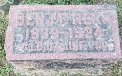

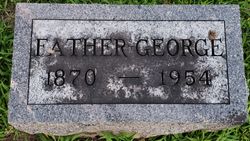
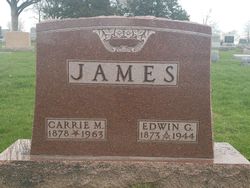
Benjamin F. Herr
| Birth | : | 3 Jul 1839 Montgomery County, Ohio, USA |
| Death | : | 19 Aug 1924 West Liberty, Muscatine County, Iowa, USA |
| Burial | : | St. Mary Magdalene Churchyard, Hucknall, Ashfield District, England |
| Coordinate | : | 53.0390630, -1.2058330 |
| Plot | : | Sec A Lot 32 Space 2 |
| Description | : | Rank: Private Unit: IA 11 Inf D G.A.R; enl 16 Sep 1861 age 22 res Wilton Muscatine IA; m.o. 17 Oct 1864 Galesville AL Based on enlistment participated in Battle of Shiloh Apr 6-7, 1862. Siege of Corinth,MS Apr 29 – May 30, 1862. Battle of Corinth Oct 3-4, 1862. Battle of Port Gibson, Raymond, Jackson, Champion's Hill, Big Black River Crossing, May 1863. Assault on Ft Beauregard, Vicksburg May 19 and 22, 1863. Siege of Vicksburg and Jackson,MS May-Jul, 1863. Battles of Kenesaw Mt, Nickajack Creek, Atlanta. siege of Atlanta, battles of Jonesboro and Lovejoy Station Jun – Aug 1864).... Read More |
frequently asked questions (FAQ):
-
Where is Benjamin F. Herr's memorial?
Benjamin F. Herr's memorial is located at: St. Mary Magdalene Churchyard, Hucknall, Ashfield District, England.
-
When did Benjamin F. Herr death?
Benjamin F. Herr death on 19 Aug 1924 in West Liberty, Muscatine County, Iowa, USA
-
Where are the coordinates of the Benjamin F. Herr's memorial?
Latitude: 53.0390630
Longitude: -1.2058330
Family Members:
Parent
Spouse
Siblings

Children

Flowers:


Nearby Cemetories:
1. St. Mary Magdalene Churchyard
Hucknall, Ashfield District, England
Coordinate: 53.0390630, -1.2058330
2. Hucknall Cemetery
Hucknall, Ashfield District, England
Coordinate: 53.0293427, -1.1988190
3. St. James Churchyard
Papplewick, Gedling Borough, England
Coordinate: 53.0582060, -1.1872990
4. Newstead Hucknall Road Cemetery
Newstead, Gedling Borough, England
Coordinate: 53.0651470, -1.2298350
5. St. Mary the Virgin Churchyard
Newstead, Gedling Borough, England
Coordinate: 53.0688200, -1.2273000
6. All Saints Churchyard
Annesley, Ashfield District, England
Coordinate: 53.0662300, -1.2501190
7. Newstead Abbey
Newstead, Gedling Borough, England
Coordinate: 53.0783450, -1.1931120
8. Northern Cemetery
Bulwell, Nottingham Unitary Authority, England
Coordinate: 52.9979840, -1.2077900
9. Annesley and Felley
Annesley, Ashfield District, England
Coordinate: 53.0771910, -1.2407140
10. St. Mary's Churchyard
Greasley, Broxtowe Borough, England
Coordinate: 53.0201100, -1.2720500
11. Redhill Cemetery
Arnold, Nottingham Unitary Authority, England
Coordinate: 53.0066910, -1.1382950
12. Kingsway New Cemetery
Kirkby-in-Ashfield, Ashfield District, England
Coordinate: 53.0917070, -1.2422500
13. Kingsway Old Cemetery
Kirkby-in-Ashfield, Ashfield District, England
Coordinate: 53.0936690, -1.2427970
14. St. Leodegarius Churchyard
Old Basford, Nottingham Unitary Authority, England
Coordinate: 52.9794240, -1.1778650
15. Basford Cemetery
Old Basford, Nottingham Unitary Authority, England
Coordinate: 52.9799700, -1.1725900
16. St. Mary's Churchyard
Eastwood, Broxtowe Borough, England
Coordinate: 53.0166227, -1.3084371
17. Eastwood Cemetery
Eastwood, Broxtowe Borough, England
Coordinate: 53.0115814, -1.3073300
18. St. Wilfrid's Churchyard Extension
Kirkby-in-Ashfield, Ashfield District, England
Coordinate: 53.0975000, -1.2693400
19. All Saints Church
Strelley, Broxtowe Borough, England
Coordinate: 52.9737900, -1.2470340
20. St. John's Carrington Churchyard
Nottingham, Nottingham Unitary Authority, England
Coordinate: 52.9755350, -1.1506790
21. Tithe Green Burial Ground
Calverton, Gedling Borough, England
Coordinate: 53.0672540, -1.0949290
22. St Mary of the Purification Churchyard
Blidworth, Newark and Sherwood District, England
Coordinate: 53.0946620, -1.1269380
23. St. Mary's Churchyard
Jacksdale, Ashfield District, England
Coordinate: 53.0577660, -1.3326300
24. St John's Church, Aldercar
Amber Valley Borough, England
Coordinate: 53.0266800, -1.3360000