
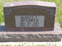
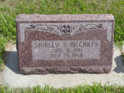
Bernice Cecelia McCarty
| Birth | : | 22 Apr 1923 Anselmo, Custer County, Nebraska, USA |
| Death | : | 31 May 2004 Callaway, Custer County, Nebraska, USA |
| Burial | : | St John the Evangelist Churchyard, Langcliffe, Craven District, England |
| Coordinate | : | 54.0807400, -2.2721000 |
frequently asked questions (FAQ):
-
Where is Bernice Cecelia McCarty's memorial?
Bernice Cecelia McCarty's memorial is located at: St John the Evangelist Churchyard, Langcliffe, Craven District, England.
-
When did Bernice Cecelia McCarty death?
Bernice Cecelia McCarty death on 31 May 2004 in Callaway, Custer County, Nebraska, USA
-
Where are the coordinates of the Bernice Cecelia McCarty's memorial?
Latitude: 54.0807400
Longitude: -2.2721000
Family Members:
Parent
Siblings


Nearby Cemetories:
1. St John the Evangelist Churchyard
Langcliffe, Craven District, England
Coordinate: 54.0807400, -2.2721000
2. Holy Ascension Churchyard
Settle, Craven District, England
Coordinate: 54.0704320, -2.2775390
3. Friends Burial Ground
Settle, Craven District, England
Coordinate: 54.0685370, -2.2791100
4. St Alkelda Churchyard
Giggleswick, Craven District, England
Coordinate: 54.0721700, -2.2894600
5. Zion Congregational Chapelyard
Settle, Craven District, England
Coordinate: 54.0672490, -2.2747040
6. St Peter Churchyard
Stainforth, Craven District, England
Coordinate: 54.1019280, -2.2754890
7. Holy Trinity Churchyard
Rathmell, Craven District, England
Coordinate: 54.0351000, -2.3002300
8. Brocklands Woodland Burial Site
Rathmell, Craven District, England
Coordinate: 54.0275720, -2.2998880
9. Long Preston Baptist Chapel
Long Preston, Craven District, England
Coordinate: 54.0204249, -2.2560031
10. Austwick Church Cemetery
Austwick, Craven District, England
Coordinate: 54.1081700, -2.3660600
11. St Mary the Virgin Churchyard
Long Preston, Craven District, England
Coordinate: 54.0183790, -2.2497690
12. St Oswald Churchyard
Horton-in-Ribblesdale, Craven District, England
Coordinate: 54.1445140, -2.2922550
13. St Michael the Archangel Churchyard
Kirkby Malham, Craven District, England
Coordinate: 54.0448480, -2.1628540
14. Clapham Parish Cemetery
Clapham, Craven District, England
Coordinate: 54.1110400, -2.3963100
15. St James Churchyard
Clapham, Craven District, England
Coordinate: 54.1202400, -2.3904970
16. St. Aidan's Churchyard
Hellifield, Craven District, England
Coordinate: 54.0042070, -2.2201370
17. St. Matthew's Churchyard
Keasden, Craven District, England
Coordinate: 54.0945680, -2.4245830
18. St Bartholomew Churchyard
Tosside, Ribble Valley Borough, England
Coordinate: 54.0002500, -2.3536700
19. Mount Sion Independent Chapelyard
Tosside, Ribble Valley Borough, England
Coordinate: 53.9982500, -2.3578200
20. St. Peter's Churchyard
Coniston Cold, Craven District, England
Coordinate: 53.9944380, -2.1493870
21. St James Churchyard
Tosside, Ribble Valley Borough, England
Coordinate: 53.9940290, -2.4029690
22. St Oswald Churchyard
Arncliffe, Craven District, England
Coordinate: 54.1434970, -2.1038940
23. Ingleton Cemetery
Ingleton, Craven District, England
Coordinate: 54.1495470, -2.4569780
24. St Leonard Churchyard
Chapel-le-Dale, Craven District, England
Coordinate: 54.1897200, -2.4032880