
| Birth | : | 4 Jun 1915 Morocco, Newton County, Indiana, USA |
| Death | : | 4 Aug 1999 Rensselaer, Jasper County, Indiana, USA |
| Burial | : | St Mary's Churchyard, Lyford, Vale of White Horse District, England |
| Coordinate | : | 51.6456433, -1.4371256 |
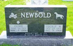
| Description | : | daughter of John E. Williams & Anna Clayton 1920 Barkley Twp., Jasper Co., IN John E Williams 37yrs b. IN, farmer Anna M. 23yrs b. IN Dortha/Dartha M. 7 11/12yrs b. IN (D. Mae b. 24 Jan 1912 Jasper Co., IN) Marril L. 6 3/12yrs b. IN Bethel M. 4 7/12yrs b. IN Velma B. 3 6/12yrs b. IN Chester C 1 5/12yrs b. IN (b. 21 Aug 1918 Jasper Co., IN) IN marriages She married Albert Carlyn Courtright 27 Jun 1936. 1940 Rensselaer, Jasper Co., IN Carlyn Courtright 31yrs b. IN, owner oil station |
frequently asked questions (FAQ):
-
Where is Bethel Lorene Williams Courtright's memorial?
Bethel Lorene Williams Courtright's memorial is located at: St Mary's Churchyard, Lyford, Vale of White Horse District, England.
-
When did Bethel Lorene Williams Courtright death?
Bethel Lorene Williams Courtright death on 4 Aug 1999 in Rensselaer, Jasper County, Indiana, USA
-
Where are the coordinates of the Bethel Lorene Williams Courtright's memorial?
Latitude: 51.6456433
Longitude: -1.4371256
Family Members:
Parent

Spouse
Siblings


Flowers:


Nearby Cemetories:
1. St Mary's Churchyard
Lyford, Vale of White Horse District, England
Coordinate: 51.6456433, -1.4371256
2. St. Peter Churchyard
Charney Bassett, Vale of White Horse District, England
Coordinate: 51.6472944, -1.4501905
3. St. James The Great Churchyard
West Hanney, Vale of White Horse District, England
Coordinate: 51.6325030, -1.4144360
4. St. James The Great Churchyard
Denchworth, Vale of White Horse District, England
Coordinate: 51.6229400, -1.4507800
5. Grove Cemetery
Grove, Vale of White Horse District, England
Coordinate: 51.6160002, -1.4299708
6. All Saints Church
Pusey, Vale of White Horse District, England
Coordinate: 51.6663890, -1.4801330
7. St. John the Baptist Churchyard
Grove, Vale of White Horse District, England
Coordinate: 51.6112858, -1.4204966
8. South Oxfordshire Memorial Park and Crematorium
Garford, Vale of White Horse District, England
Coordinate: 51.6535980, -1.3767840
9. All Saints Churchyard
Goosey, Vale of White Horse District, England
Coordinate: 51.6225320, -1.4865200
10. St. Luke's Churchyard
Garford, Vale of White Horse District, England
Coordinate: 51.6637514, -1.3815467
11. St. John the Baptist Churchyard
Kingston Bagpuize, Vale of White Horse District, England
Coordinate: 51.6820690, -1.4127410
12. Strict Baptist Chapel
Grove, Vale of White Horse District, England
Coordinate: 51.6051668, -1.4219236
13. St Deny's Churchyard
Stanford-in-the-Vale, Vale of White Horse District, England
Coordinate: 51.6399960, -1.5062800
14. St. Margaret Churchyard
Hinton Waldrist, Vale of White Horse District, England
Coordinate: 51.6894380, -1.4587200
15. St George's Parish Church
Hatford, Vale of White Horse District, England
Coordinate: 51.6510000, -1.5120000
16. Saint Mary Churchyard
Longworth, Vale of White Horse District, England
Coordinate: 51.6926577, -1.4457428
17. St Margaret of Antioch Churchyard Extension
Hinton Waldrist, Vale of White Horse District, England
Coordinate: 51.6911016, -1.4589705
18. St Nicholas Churchyard
Fyfield, Vale of White Horse District, England
Coordinate: 51.6871100, -1.3888600
19. St. Nicholas Churchyard
East Challow, Vale of White Horse District, England
Coordinate: 51.5919480, -1.4518960
20. St George Roman Catholic Churchyard
Buckland, Vale of White Horse District, England
Coordinate: 51.6804300, -1.5068720
21. St Mary Churchyard
Buckland, Vale of White Horse District, England
Coordinate: 51.6819730, -1.5060150
22. Wantage Baptist Church
Wantage, Vale of White Horse District, England
Coordinate: 51.5892190, -1.4270540
23. St. Peter and Paul Churchyard
Wantage, Vale of White Horse District, England
Coordinate: 51.5886860, -1.4284970
24. St. Laurence Churchyard
West Challow, Vale of White Horse District, England
Coordinate: 51.5920920, -1.4708930