
| Birth | : | 22 Nov 1928 Council Bluffs, Pottawattamie County, Iowa, USA |
| Death | : | 3 Mar 2003 Idaho Falls, Bonneville County, Idaho, USA |
| Burial | : | Ridgewood Cemetery, Council Bluffs, Pottawattamie County, USA |
| Coordinate | : | 41.2694016, -95.8272018 |
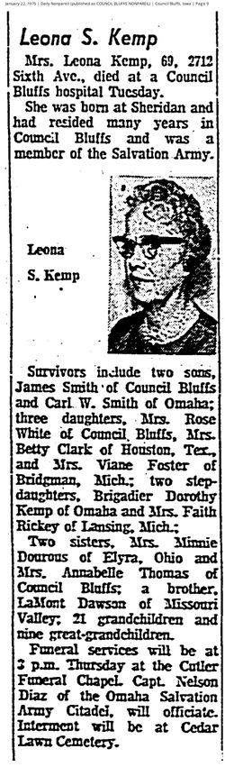
| Description | : | Betty was born to Carl William Smith and Eva Leona Dawson Kemp, grew up in Council Bluffs and attended Thomas Jefferson High School. She and Donald were married in Nebraska City, NE, on June 22, 1965. She was a homemaker, a loving wife and mother and grandmother, a member of the Gethsemane Baptist Church and a former member of the First Church of the Nazarene in Idaho Falls. She enjoyed reading, listening to Bill Gaither Christian music, and loved children, working on computer, and attending church. Survivors beside Donald included: children Dale Morehouse of Tempe, AZ, and Carole Montgomery... Read More |
frequently asked questions (FAQ):
-
Where is Betty Jean Smith Clark's memorial?
Betty Jean Smith Clark's memorial is located at: Ridgewood Cemetery, Council Bluffs, Pottawattamie County, USA.
-
When did Betty Jean Smith Clark death?
Betty Jean Smith Clark death on 3 Mar 2003 in Idaho Falls, Bonneville County, Idaho, USA
-
Where are the coordinates of the Betty Jean Smith Clark's memorial?
Latitude: 41.2694016
Longitude: -95.8272018
Family Members:
Parent
Spouse

Siblings
Children
Flowers:


Nearby Cemetories:
1. Ridgewood Cemetery
Council Bluffs, Pottawattamie County, USA
Coordinate: 41.2694016, -95.8272018
2. Walnut Hill Cemetery
Council Bluffs, Pottawattamie County, USA
Coordinate: 41.2719002, -95.8255997
3. Bikhor Cholim Cemetery
Council Bluffs, Pottawattamie County, USA
Coordinate: 41.2703670, -95.8229350
4. Oak Hill Cemetery
Council Bluffs, Pottawattamie County, USA
Coordinate: 41.2700900, -95.8226400
5. Memorial Park Cemetery
Council Bluffs, Pottawattamie County, USA
Coordinate: 41.2644005, -95.8261032
6. Saint Joseph Cemetery
Council Bluffs, Pottawattamie County, USA
Coordinate: 41.2722015, -95.8208008
7. Green Valley Cemetery
Council Bluffs, Pottawattamie County, USA
Coordinate: 41.2743988, -95.8225021
8. Cedar Lawn Cemetery
Council Bluffs, Pottawattamie County, USA
Coordinate: 41.2694016, -95.8182983
9. Clark Cemetery
Pottawattamie County, USA
Coordinate: 41.2551610, -95.8223390
10. Fairview Cemetery
Council Bluffs, Pottawattamie County, USA
Coordinate: 41.2703018, -95.8480988
11. Garner Cemetery
Council Bluffs, Pottawattamie County, USA
Coordinate: 41.2956161, -95.8001709
12. Stoker-Graybill Cemetery
Council Bluffs, Pottawattamie County, USA
Coordinate: 41.2532620, -95.7751770
13. Maple Grove Cemetery
Council Bluffs, Pottawattamie County, USA
Coordinate: 41.2265560, -95.8187100
14. Evans Cemetery
Crescent, Pottawattamie County, USA
Coordinate: 41.3255997, -95.8368988
15. Lewis Township Cemetery
Council Bluffs, Pottawattamie County, USA
Coordinate: 41.2117004, -95.7938995
16. Gregg Cemetery
Weston, Pottawattamie County, USA
Coordinate: 41.3330000, -95.7931000
17. Council Point Cemetery
Council Bluffs, Pottawattamie County, USA
Coordinate: 41.2110830, -95.8788610
18. Hazel Dell Cemetery
Council Bluffs, Pottawattamie County, USA
Coordinate: 41.3489723, -95.7939911
19. Trinity Cathedral Columbarium
Omaha, Douglas County, USA
Coordinate: 41.2603900, -95.9393660
20. Saint Columbanus Cemetery
Weston, Pottawattamie County, USA
Coordinate: 41.3429440, -95.7435260
21. Crescent Cemetery
Crescent, Pottawattamie County, USA
Coordinate: 41.3664894, -95.8566208
22. Prospect Hill Cemetery
Omaha, Douglas County, USA
Coordinate: 41.2780991, -95.9593964
23. First Central Congregational Columbarium
Omaha, Douglas County, USA
Coordinate: 41.2563456, -95.9658365
24. Nash Chapel Crypt
Omaha, Douglas County, USA
Coordinate: 41.2665090, -95.9721790