
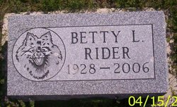
Betty L. Shoemaker Rider
| Birth | : | 5 Jun 1928 Chicago, Cook County, Illinois, USA |
| Death | : | 24 May 2006 Loveland, Larimer County, Colorado, USA |
| Burial | : | St. Michael's Churchyard, Foulridge, Pendle Borough, England |
| Coordinate | : | 53.8734569, -2.1693508 |
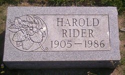
| Description | : | Betty L. Rider, 78, of Loveland, Colorado, formerly of Farmington, has passed away. She was born to Donne Willard and Lelia Evelyn Becker Shoemaker. On June 5, 1945, she married Harold Everett Rider in Keosauqua. He died April 5, 1986. Mrs. Rider was a partner in Rider Nursery & Floral in Farmington and she started Rider Floral. She also worked as an assistant at the Famington Public Library. She and he husband helped found the first Strawberry Appreciation Day which grew into the Farmington Strawberry Festival. She was a member of First Baptist Church in Farmington and taught Sunday school. She enjoyed cooking, walking... Read More |
frequently asked questions (FAQ):
-
Where is Betty L. Shoemaker Rider's memorial?
Betty L. Shoemaker Rider's memorial is located at: St. Michael's Churchyard, Foulridge, Pendle Borough, England.
-
When did Betty L. Shoemaker Rider death?
Betty L. Shoemaker Rider death on 24 May 2006 in Loveland, Larimer County, Colorado, USA
-
Where are the coordinates of the Betty L. Shoemaker Rider's memorial?
Latitude: 53.8734569
Longitude: -2.1693508
Family Members:
Spouse
Flowers:


Nearby Cemetories:
1. St. Michael's Churchyard
Foulridge, Pendle Borough, England
Coordinate: 53.8734569, -2.1693508
2. Friends Burial Ground
Foulridge, Pendle Borough, England
Coordinate: 53.8769360, -2.1669040
3. St. Bartholomew Churchyard
Colne, Pendle Borough, England
Coordinate: 53.8570600, -2.1700470
4. Colne Cemetery
Colne, Pendle Borough, England
Coordinate: 53.8577420, -2.1585350
5. West Street Inghamite Chapel Chapelyard
Colne, Pendle Borough, England
Coordinate: 53.8555930, -2.1672140
6. Christ Church Churchyard
Colne, Pendle Borough, England
Coordinate: 53.8602110, -2.1415670
7. New Lane Inghamite Cemetery
Winewall, Pendle Borough, England
Coordinate: 53.8548000, -2.1367150
8. St Mary's Churchyard
Kelbrook, Pendle Borough, England
Coordinate: 53.8991000, -2.1494100
9. Barrowford Cemetery
Nelson, Pendle Borough, England
Coordinate: 53.8521100, -2.2130300
10. Trawden Wesley Chapel Graveyard
Trawden Forest, Pendle Borough, England
Coordinate: 53.8459885, -2.1355791
11. Nelson Cemetery
Nelson, Pendle Borough, England
Coordinate: 53.8420330, -2.1972230
12. St. Mary the Virgin Churchyard
Trawden Forest, Pendle Borough, England
Coordinate: 53.8431010, -2.1366050
13. St. Thomas Churchyard
Barrowford, Pendle Borough, England
Coordinate: 53.8513900, -2.2196600
14. Salterforth Cemetery
Salterforth, Pendle Borough, England
Coordinate: 53.9123170, -2.1654010
15. St. John the Evangelist Churchyard
Nelson, Pendle Borough, England
Coordinate: 53.8367000, -2.1977200
16. All Souls Cemetery
Barrowford, Pendle Borough, England
Coordinate: 53.8462900, -2.2355600
17. Earby Cemetery
Earby, Pendle Borough, England
Coordinate: 53.9189987, -2.1370001
18. St. Paul's Churchyard
Nelson, Pendle Borough, England
Coordinate: 53.8289250, -2.2157520
19. John Ecroyd's Orchard
Lancaster, City of Lancaster, England
Coordinate: 53.8201990, -2.1697920
20. Ghyll Cemetery
Barnoldswick, Pendle Borough, England
Coordinate: 53.9271100, -2.1646700
21. Saint Mary-le-Ghyll
Barnoldswick, Pendle Borough, England
Coordinate: 53.9279505, -2.1647004
22. Wheatley Lane Inghamite Church Churchyard
Wheatley Lane, Pendle Borough, England
Coordinate: 53.8412800, -2.2457100
23. Marsden Friends Burial Ground
Marsden, Metropolitan Borough of Kirklees, England
Coordinate: 53.8241910, -2.2197410
24. Hill Lane Baptist Church Churchyard
Briercliffe, Burnley Borough, England
Coordinate: 53.8161467, -2.1875368