
Beulah Elizabeth leavitt Colby
| Birth | : | 25 Oct 1923 USA |
| Death | : | 23 Mar 1980 Topsham, Sagadahoc County, Maine, USA |
| Burial | : | Emery Gates Cemetery, Ash, Guildford Borough, England |
| Coordinate | : | 51.2500370, -0.7163210 |
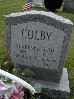
| Inscription | : | BEULAH E. HIS WIFE 1923-1980 |
| Description | : | Death Archives Single Record Display Certificate Number: 8002595 Last Name: COLBY First Name: BEULAH Middle Name: -0- Date of Death: Sunday, March 23, 1980 Town of Death: TOPSHAM Age at Death: 56 Years |
frequently asked questions (FAQ):
-
Where is Beulah Elizabeth leavitt Colby's memorial?
Beulah Elizabeth leavitt Colby's memorial is located at: Emery Gates Cemetery, Ash, Guildford Borough, England.
-
When did Beulah Elizabeth leavitt Colby death?
Beulah Elizabeth leavitt Colby death on 23 Mar 1980 in Topsham, Sagadahoc County, Maine, USA
-
Where are the coordinates of the Beulah Elizabeth leavitt Colby's memorial?
Latitude: 51.2500370
Longitude: -0.7163210
Family Members:
Spouse
Flowers:


Nearby Cemetories:
1. Emery Gates Cemetery
Ash, Guildford Borough, England
Coordinate: 51.2500370, -0.7163210
2. St Peter Churchyard
Ash, Guildford Borough, England
Coordinate: 51.2490760, -0.7155380
3. Ash War Memorial
Ash, Guildford Borough, England
Coordinate: 51.2546746, -0.7157783
4. Aldershot Military Cemetery
Aldershot, Rushmoor Borough, England
Coordinate: 51.2554779, -0.7449350
5. Aldershot Jewish Cemetery
Aldershot, Rushmoor Borough, England
Coordinate: 51.2508900, -0.7463000
6. Redan Road Cemetery
Aldershot, Rushmoor Borough, England
Coordinate: 51.2495610, -0.7488900
7. St. Mark's Churchyard
Pirbright, Guildford Borough, England
Coordinate: 51.2549050, -0.6812810
8. Aldershot Crematorium
Aldershot, Rushmoor Borough, England
Coordinate: 51.2325970, -0.7443200
9. St Michael the Archangel Churchyard
Aldershot, Rushmoor Borough, England
Coordinate: 51.2414300, -0.7558900
10. St Lawrence Churchyard
Seale, Guildford Borough, England
Coordinate: 51.2231840, -0.7170140
11. St. Bartholomew's Churchyard
Wanborough, Guildford Borough, England
Coordinate: 51.2317700, -0.6625100
12. St. John the Baptist Churchyard
Puttenham, Guildford Borough, England
Coordinate: 51.2222610, -0.6650440
13. Puttenham Cemetery
Puttenham, Guildford Borough, England
Coordinate: 51.2204130, -0.6590980
14. St. Peter's Churchyard
Farnborough, Rushmoor Borough, England
Coordinate: 51.2924100, -0.7499300
15. Saint John the Evangelist Churchyard
Hale, Waverley Borough, England
Coordinate: 51.2280880, -0.7849360
16. St Michael's Abbey
Farnborough, Rushmoor Borough, England
Coordinate: 51.2971140, -0.7497110
17. Victoria Road Cemetery
Farnborough, Rushmoor Borough, England
Coordinate: 51.2941300, -0.7593900
18. Upper Hale Cemetery
Farnham, Waverley Borough, England
Coordinate: 51.2352700, -0.8001800
19. Deepcut Military Cemetery
Deepcut, Surrey Heath Borough, England
Coordinate: 51.3062170, -0.7049060
20. St. Mary's Churchyard
Shackleford, Guildford Borough, England
Coordinate: 51.2017210, -0.6629560
21. Ship Lane Cemetery
Farnborough, Rushmoor Borough, England
Coordinate: 51.3057800, -0.7488900
22. St Michael and All Angels Churchyard
Pirbright, Guildford Borough, England
Coordinate: 51.2945800, -0.6500000
23. Compton Village Cemetery
Compton, Guildford Borough, England
Coordinate: 51.2181370, -0.6326920
24. St. Nicholas' Churchyard
Compton, Guildford Borough, England
Coordinate: 51.2145300, -0.6348400