

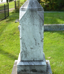
Capt Henry Sewell Albee
| Birth | : | Mar 1804 Wiscasset, Lincoln County, Maine, USA |
| Death | : | 2 Aug 1885 Alna, Lincoln County, Maine, USA |
| Burial | : | Saint Peters Cemetery, Sandwich, Barnstable County, USA |
| Coordinate | : | 41.7502480, -70.5079346 |
| Plot | : | C 12 |
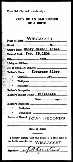
| Description | : | Captain Sewall Albee & his wife Margaret lost three of their sons at sea. Each in different years, 1853, 1856 & 1863. Name: Henry Sewall Albee Birth Date: 25 Feb 1804 Birth Place: Wiscasset, Lincoln, Maine, USA Father: Ebenezer Albee Mother: Elizabeth Albee Sources: Maine, U.S., Birth Records, 1715-1922 |
frequently asked questions (FAQ):
-
Where is Capt Henry Sewell Albee's memorial?
Capt Henry Sewell Albee's memorial is located at: Saint Peters Cemetery, Sandwich, Barnstable County, USA.
-
When did Capt Henry Sewell Albee death?
Capt Henry Sewell Albee death on 2 Aug 1885 in Alna, Lincoln County, Maine, USA
-
Where are the coordinates of the Capt Henry Sewell Albee's memorial?
Latitude: 41.7502480
Longitude: -70.5079346
Family Members:
Parent
Spouse
Siblings

Children


Flowers:


Nearby Cemetories:
1. Saint Peters Cemetery
Sandwich, Barnstable County, USA
Coordinate: 41.7502480, -70.5079346
2. Freeman Cemetery
Sandwich, Barnstable County, USA
Coordinate: 41.7573013, -70.5083008
3. Old Town Cemetery
Sandwich, Barnstable County, USA
Coordinate: 41.7556992, -70.5011978
4. Bay View Cemetery
Sandwich, Barnstable County, USA
Coordinate: 41.7583008, -70.5102997
5. Mount Hope Cemetery
Sandwich, Barnstable County, USA
Coordinate: 41.7518997, -70.4850006
6. Almshouse Burial Ground
Sandwich, Barnstable County, USA
Coordinate: 41.7501000, -70.4847000
7. Saddle and Pillion Cemetery
Sagamore, Barnstable County, USA
Coordinate: 41.7672005, -70.5192032
8. Spring Hill Cemetery
Sandwich, Barnstable County, USA
Coordinate: 41.7487984, -70.4775009
9. Sagamore Cemetery
Bourne, Barnstable County, USA
Coordinate: 41.7714005, -70.5339966
10. Old Quaker Meeting House Cemetery at Spring Hill
Sandwich, Barnstable County, USA
Coordinate: 41.7463100, -70.4613060
11. Quaker Meeting House Cemetery
East Sandwich, Barnstable County, USA
Coordinate: 41.7469673, -70.4591064
12. Sandwich Town Cemetery
Sandwich, Barnstable County, USA
Coordinate: 41.7125300, -70.4909000
13. Bournedale Burying Hill
Bourne, Barnstable County, USA
Coordinate: 41.7741520, -70.5611730
14. Cedarville Cemetery
East Sandwich, Barnstable County, USA
Coordinate: 41.7397804, -70.4428864
15. Tobey Cemetery
Forestdale, Barnstable County, USA
Coordinate: 41.6972008, -70.4875031
16. Bournedale Herring Pond Indian Cemetery
Bourne, Barnstable County, USA
Coordinate: 41.7861900, -70.5658722
17. Herring Pond Wampanoag Indian Cemetery
Plymouth, Plymouth County, USA
Coordinate: 41.7867290, -70.5658940
18. Forestdale Cemetery
Forestdale, Barnstable County, USA
Coordinate: 41.6903000, -70.5024033
19. Herring Pond Cemetery
Plymouth, Plymouth County, USA
Coordinate: 41.7971700, -70.5588800
20. Bourne Village Cemetery
Bourne, Barnstable County, USA
Coordinate: 41.7425117, -70.5938110
21. Cedarville Cemetery
Plymouth, Plymouth County, USA
Coordinate: 41.8049736, -70.5560837
22. Old Bourne Cemetery
Bourne, Barnstable County, USA
Coordinate: 41.7386017, -70.5986023
23. Bourne Family Cemetery #02
Bourne, Barnstable County, USA
Coordinate: 41.7577230, -70.6001190
24. Bourne Family Cemetery
Bourne, Barnstable County, USA
Coordinate: 41.7501602, -70.6032104