
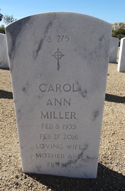
Carol Ann Warnick Miller
| Birth | : | 8 Feb 1935 Garrett County, Maryland, USA |
| Death | : | 27 Feb 2016 USA |
| Burial | : | Bakersfield National Cemetery, Arvin, Kern County, USA |
| Coordinate | : | 35.2559600, -118.6693480 |
| Plot | : | Section 8 Site 275 |
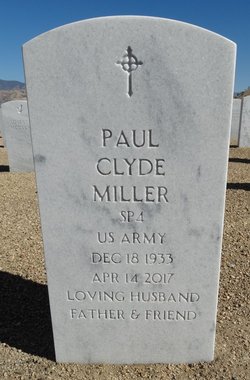
| Description | : | Wife of Paul Clyde Miller, SP4 US ARMY, KOREA. Carol and Paul are interred together. |
frequently asked questions (FAQ):
-
Where is Carol Ann Warnick Miller's memorial?
Carol Ann Warnick Miller's memorial is located at: Bakersfield National Cemetery, Arvin, Kern County, USA.
-
When did Carol Ann Warnick Miller death?
Carol Ann Warnick Miller death on 27 Feb 2016 in USA
-
Where are the coordinates of the Carol Ann Warnick Miller's memorial?
Latitude: 35.2559600
Longitude: -118.6693480
Family Members:
Parent

Spouse
Siblings
Flowers:


Nearby Cemetories:
1. Bakersfield National Cemetery
Arvin, Kern County, USA
Coordinate: 35.2559600, -118.6693480
2. Fickert Family Cemetery
Bear Valley Springs, Kern County, USA
Coordinate: 35.1697260, -118.6443350
3. Cesar E. Chavez National Monument
Keene, Kern County, USA
Coordinate: 35.2236000, -118.5592400
4. Tehachapi Cove Cemetery
Tehachapi, Kern County, USA
Coordinate: 35.1190000, -118.5724600
5. Rankin Cemetery
Walker Basin, Kern County, USA
Coordinate: 35.3844560, -118.5388890
6. Brite Family Cemetery
Tehachapi, Kern County, USA
Coordinate: 35.1085350, -118.5473470
7. Arvin Cemetery
Arvin, Kern County, USA
Coordinate: 35.2132300, -118.8952700
8. Old Tehachapi Cemetery
Tehachapi, Kern County, USA
Coordinate: 35.1400990, -118.4795570
9. Paris-Loraine Cemetery
Loraine, Kern County, USA
Coordinate: 35.3059000, -118.4355000
10. Tehachapi Westside Cemetery
Tehachapi, Kern County, USA
Coordinate: 35.1387400, -118.4633600
11. Tejon Indian Settlement Cemetery
Kern County, USA
Coordinate: 35.0422000, -118.6553900
12. Hillcrest Memorial Park
Bakersfield, Kern County, USA
Coordinate: 35.3814316, -118.9012527
13. Buhn Ranch Cemetery
Tehachapi, Kern County, USA
Coordinate: 35.1352210, -118.4319290
14. Williams Burial Site
Walker Basin, Kern County, USA
Coordinate: 35.4320950, -118.4815680
15. Tehachapi Eastside Cemetery
Tehachapi, Kern County, USA
Coordinate: 35.1329000, -118.4153200
16. Kuntz Ranch Cemetery
Bakersfield, Kern County, USA
Coordinate: 35.4373560, -118.9390180
17. Saint Joseph Cemetery
Havilah, Kern County, USA
Coordinate: 35.5147500, -118.5177700
18. Union Cemetery
Bakersfield, Kern County, USA
Coordinate: 35.3646500, -118.9948700
19. Home of Peace Jewish Cemetery
Bakersfield, Kern County, USA
Coordinate: 35.3631500, -118.9987400
20. Greenlawn Cemetery and Mortuary
Bakersfield, Kern County, USA
Coordinate: 35.4067001, -118.9856033
21. Greenlawn Southwest Mortuary and Cemetery
Bakersfield, Kern County, USA
Coordinate: 35.2948990, -119.0330810
22. Chinese Cemetery
Bakersfield, Kern County, USA
Coordinate: 35.3510550, -119.0273380
23. Sand Canyon Cemetery
Tehachapi, Kern County, USA
Coordinate: 35.1331320, -118.3150210
24. Saint Pauls Episcopal Church Columbarium
Bakersfield, Kern County, USA
Coordinate: 35.3746120, -119.0277940