
| Birth | : | 20 Jan 1823 Cobourg, Northumberland County, Ontario, Canada |
| Death | : | 17 Jun 1910 Fruitland, Wicomico County, Maryland, USA |
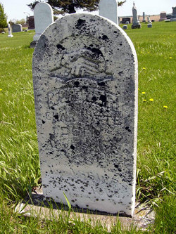
| Burial | : | Mossley Cemetery, Mossley, Metropolitan Borough of Tameside, England |
| Coordinate | : | 53.5092100, -2.0332700 |
| Description | : | Obituary-Monona Leader - June 23, 1910:Caroline Dory was born in Quebec, Canada. Later moved with her parents to Wisconsin, where in 1847 she was married to Charles E. Smith, who in 1849 started to the gold fields of California, and died before reaching his destination. One son, C.D. Smith of Jackson, CA was born to this union. In 1854, in Illinois, she was married to George Coon, coming to Iowa the same year, settling on a farm North of Luana, whre Mr. Coon died in 1892. There were nine children born to this union, three of them survived the mother.... Read More |
frequently asked questions (FAQ):
-
Where is Caroline Dory Coon's memorial?
Caroline Dory Coon's memorial is located at: Mossley Cemetery, Mossley, Metropolitan Borough of Tameside, England.
-
When did Caroline Dory Coon death?
Caroline Dory Coon death on 17 Jun 1910 in Fruitland, Wicomico County, Maryland, USA
-
Where are the coordinates of the Caroline Dory Coon's memorial?
Latitude: 53.5092100
Longitude: -2.0332700
Family Members:
Parent

Spouse
Siblings
Children


Nearby Cemetories:
1. Mossley Cemetery
Mossley, Metropolitan Borough of Tameside, England
Coordinate: 53.5092100, -2.0332700
2. St. George Parish Churchyard
Mossley, Metropolitan Borough of Tameside, England
Coordinate: 53.5164000, -2.0486200
3. Hurst Cemetery
Ashton-Under-Lyne, Metropolitan Borough of Tameside, England
Coordinate: 53.5011590, -2.0727370
4. St Paul Churchyard
Stalybridge, Metropolitan Borough of Tameside, England
Coordinate: 53.4852000, -2.0440300
5. St Georges Cemetery
Stalybridge, Metropolitan Borough of Tameside, England
Coordinate: 53.4873400, -2.0576800
6. St George's Old Churchyard
Stalybridge, Metropolitan Borough of Tameside, England
Coordinate: 53.4844700, -2.0538800
7. St. John the Evangelist Churchyard
Hurst, Metropolitan Borough of Tameside, England
Coordinate: 53.5001310, -2.0812490
8. Bethel Chapel Chapelyard
Stalybridge, Metropolitan Borough of Tameside, England
Coordinate: 53.4820413, -2.0576195
9. Lees Cemetery
Oldham, Metropolitan Borough of Oldham, England
Coordinate: 53.5347540, -2.0739260
10. St Thomas'
Oldham, Metropolitan Borough of Oldham, England
Coordinate: 53.5366318, -2.0724053
11. St. John the Baptist Churchyard
Heybridge, Central Coast Council, Australia
Coordinate: 53.5415973, -2.0699727
12. St. John The Baptist Churchyard
Oldham, Metropolitan Borough of Oldham, England
Coordinate: 53.5424690, -2.0680150
13. St John's Churchyard
Dukinfield, Metropolitan Borough of Tameside, England
Coordinate: 53.4771000, -2.0726000
14. Dukinfield Cemetery and Crematorium
Dukinfield, Metropolitan Borough of Tameside, England
Coordinate: 53.4800300, -2.0857150
15. Greenacres Congregational Church
Oldham, Metropolitan Borough of Oldham, England
Coordinate: 53.5455200, -2.0788100
16. Greenacres Cemetery
Oldham, Metropolitan Borough of Oldham, England
Coordinate: 53.5455490, -2.0820510
17. St Mary's Churchyard
Hyde, Metropolitan Borough of Tameside, England
Coordinate: 53.4652400, -2.0599700
18. Holy Trinity Churchyard
Waterhead, Metropolitan Borough of Oldham, England
Coordinate: 53.5507100, -2.0738400
19. St. Peter's Churchyard
Ashton-Under-Lyne, Metropolitan Borough of Tameside, England
Coordinate: 53.4839340, -2.1054690
20. Hollingworth United Methodist Cemetery
Hollingworth, Metropolitan Borough of Tameside, England
Coordinate: 53.4632891, -1.9958244
21. St. Chad Churchyard
Uppermill, Metropolitan Borough of Oldham, England
Coordinate: 53.5542570, -1.9901190
22. Tintwistle Churchyard
Tintwistle, High Peak Borough, England
Coordinate: 53.4719150, -1.9685915
23. United Reformed Church
Tintwistle, High Peak Borough, England
Coordinate: 53.4729900, -1.9657910
24. Mottram Cemetery
Mottram in Longdendale, Metropolitan Borough of Tameside, England
Coordinate: 53.4546420, -2.0086900