
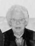
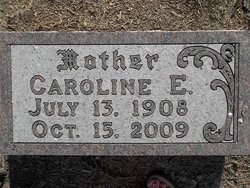
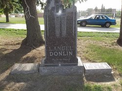
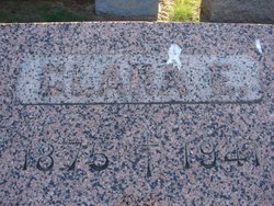
Caroline E Kunkel Donlin
| Birth | : | 13 Jul 1908 Plymouth County, Iowa, USA |
| Death | : | 15 Oct 2009 Le Mars, Plymouth County, Iowa, USA |
| Burial | : | Mangatainoka Cemetery, Pahiatua, Tararua District, New Zealand |
| Coordinate | : | -40.4250620, 175.8597850 |
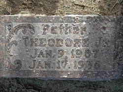
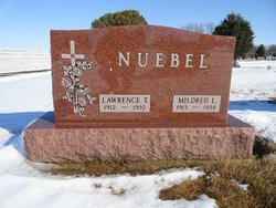
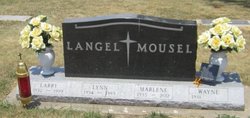
| Description | : | Le Mars Daily Sentinel, IA, Tuesday, November 3, 2009 Caroline (Langel) Donlin of Le Mars died Thursday, Oct. 15, 2009, at Good Samaritan Society-Le Mars at the age of 101. The former Caroline Elizabeth Kunkel was born July 13, 1908, on a farm near Oyens, the daughter of Frank and Clara (Becker) Kunkel. On Jan. 14, 1930, she married Theodore Langel, Jr. at St. Joseph's Catholic Church in Le Mars. To this union, four children were born. They farmed northwest of Oyens for a few years until her husband died Jan. 17, 1936, at which time she moved into Le Mars. When her... Read More |
frequently asked questions (FAQ):
-
Where is Caroline E Kunkel Donlin's memorial?
Caroline E Kunkel Donlin's memorial is located at: Mangatainoka Cemetery, Pahiatua, Tararua District, New Zealand.
-
When did Caroline E Kunkel Donlin death?
Caroline E Kunkel Donlin death on 15 Oct 2009 in Le Mars, Plymouth County, Iowa, USA
-
Where are the coordinates of the Caroline E Kunkel Donlin's memorial?
Latitude: -40.4250620
Longitude: 175.8597850
Family Members:
Parent
Spouse
Siblings

Children

Flowers:


Nearby Cemetories:
1. Mangatainoka Cemetery
Pahiatua, Tararua District, New Zealand
Coordinate: -40.4250620, 175.8597850
2. Mangahao Cemetery
Ballance, Tararua District, New Zealand
Coordinate: -40.4276820, 175.7890440
3. Kaitawa Cemetery
Kaitawa, Tararua District, New Zealand
Coordinate: -40.4939310, 175.8824710
4. Lawn Woodville Cemetery
Woodville, Tararua District, New Zealand
Coordinate: -40.3390540, 175.8807710
5. RSA Woodville Cemetery
Woodville, Tararua District, New Zealand
Coordinate: -40.3362310, 175.8345210
6. Old Gorge Cemetery
Woodville, Tararua District, New Zealand
Coordinate: -40.3361206, 175.8332520
7. Ashhurst Cemetery
Ashhurst, Palmerston North City, New Zealand
Coordinate: -40.3013600, 175.7576040
8. Kumeroa Cemetery
Kumeroa, Tararua District, New Zealand
Coordinate: -40.3294480, 176.0238960
9. Kelvin Grove Cemetery
Palmerston North, Palmerston North City, New Zealand
Coordinate: -40.3239060, 175.6616870
10. Terrace End Cemetery
Palmerston North, Palmerston North City, New Zealand
Coordinate: -40.3427170, 175.6433160
11. St Peter's Anglican Church
Roslyn, Palmerston North City, New Zealand
Coordinate: -40.3468897, 175.6279770
12. All Saint's Anglican Church
Palmerston North, Palmerston North City, New Zealand
Coordinate: -40.3581590, 175.6107926
13. Newman Cemetery
Eketahuna, Tararua District, New Zealand
Coordinate: -40.6154770, 175.7134490
14. Bunnythorpe Cemetery
Palmerston North, Palmerston North City, New Zealand
Coordinate: -40.2867770, 175.6272590
15. Tahoraiti Urupā
Dannevirke, Tararua District, New Zealand
Coordinate: -40.2428680, 176.0574580
16. First Cemetery of Eketahuna
Eketahuna, Tararua District, New Zealand
Coordinate: -40.6467990, 175.7136840
17. Alfredton Cemetery
Alfredton, Tararua District, New Zealand
Coordinate: -40.6808500, 175.8670160
18. Pohangina Cemetery
Pohangina, Manawatu District, New Zealand
Coordinate: -40.1682490, 175.7946660
19. Eketahuna Lawn Cemetery
Eketahuna, Tararua District, New Zealand
Coordinate: -40.6538700, 175.6883400
20. Calleson Family Cemetery
Palmerston North, Palmerston North City, New Zealand
Coordinate: -40.3814600, 175.5157840
21. Aorangi Urupā
Manawatu District, New Zealand
Coordinate: -40.2443660, 175.5870110
22. Pongaroa cemetery
Pahiatua, Tararua District, New Zealand
Coordinate: -40.5448890, 176.1975300
23. Settlers Cemetery
Dannevirke, Tararua District, New Zealand
Coordinate: -40.2046600, 176.1107900
24. Mangatera Cemetery
Dannevirke, Tararua District, New Zealand
Coordinate: -40.1883520, 176.1180990