
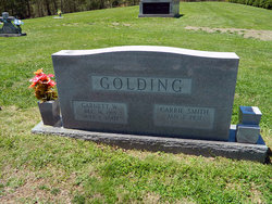
Carrie Lou Smith Golding
| Birth | : | 7 Jan 1931 Surry County, North Carolina, USA |
| Death | : | 19 Sep 2018 Mount Airy, Surry County, North Carolina, USA |
| Burial | : | Ladonia Baptist Church Cemetery, Ladonia, Surry County, USA |
| Coordinate | : | 36.4780280, -80.8386670 |
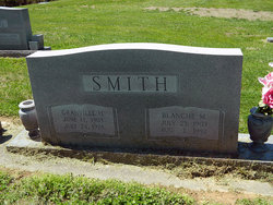
| Description | : | Mrs. Carrie Lou Smith Golding, 87, of Mount Airy, passed away Wednesday afternoon, September 19, 2018, at her home. Mrs. Golding was born January 7, 1931, in Surry County, one of four children of Granville H. and Blanche Mayes Smith. Carrie retired as the snack shop manager at Northern Hospital of Surry County. She was a member of Ladonia Baptist Church, and a member and past matron of Mount Airy Chapter #18 Order of the Eastern Star. In addition to her parents, Mrs. Golding was preceded in death by her husband, Garnett... Read More |
frequently asked questions (FAQ):
-
Where is Carrie Lou Smith Golding's memorial?
Carrie Lou Smith Golding's memorial is located at: Ladonia Baptist Church Cemetery, Ladonia, Surry County, USA.
-
When did Carrie Lou Smith Golding death?
Carrie Lou Smith Golding death on 19 Sep 2018 in Mount Airy, Surry County, North Carolina, USA
-
Where are the coordinates of the Carrie Lou Smith Golding's memorial?
Latitude: 36.4780280
Longitude: -80.8386670
Family Members:
Parent

Spouse

Siblings
Flowers:


Nearby Cemetories:
1. Ladonia Baptist Church Cemetery
Ladonia, Surry County, USA
Coordinate: 36.4780280, -80.8386670
2. Isaacks Family Cemetery
Mount Airy, Surry County, USA
Coordinate: 36.4621670, -80.8236670
3. Sarah Isaacs Cemetery
Franklin, Surry County, USA
Coordinate: 36.4636110, -80.8205830
4. Amazing Grace Baptist Church Cemetery
Ladonia, Surry County, USA
Coordinate: 36.4588700, -80.8254250
5. Mount Vernon Baptist Church Cemetery
Beulah, Surry County, USA
Coordinate: 36.5003624, -80.8213882
6. New Bethel Baptist Church Cemetery
Ladonia, Surry County, USA
Coordinate: 36.4505610, -80.8420590
7. Edwards-Franklin House Grounds
Mount Airy, Surry County, USA
Coordinate: 36.4541664, -80.8181915
8. New Life Baptist Cemetery
Mount Airy, Surry County, USA
Coordinate: 36.4524994, -80.8030548
9. Payne Cemetery
Lowgap, Surry County, USA
Coordinate: 36.4947220, -80.7928060
10. Carpenter - Snow Family Cemetery
Dobson, Surry County, USA
Coordinate: 36.4523330, -80.8820280
11. Mountain View Baptist Church Cemetery
Lowgap, Surry County, USA
Coordinate: 36.5197420, -80.8645570
12. Beulah United Methodist Church Cemetery
Beulah, Surry County, USA
Coordinate: 36.4865160, -80.7795830
13. Nixon Family Cemetery
Surry County, USA
Coordinate: 36.4445830, -80.7949720
14. Speer Family Cemetery
Mount Airy, Surry County, USA
Coordinate: 36.4443333, -80.7945000
15. Cox Family Cemetery
Dobson, Surry County, USA
Coordinate: 36.4391700, -80.7983300
16. Cockerham Family Cemetery
Lowgap, Surry County, USA
Coordinate: 36.5284720, -80.8465830
17. Barker Graveyard
Lowgap, Surry County, USA
Coordinate: 36.5295540, -80.8340600
18. Country Baptist Church Cemetery
Beulah, Surry County, USA
Coordinate: 36.4662230, -80.7760980
19. Roaring Gap Baptist Church Cemetery
Lowgap, Surry County, USA
Coordinate: 36.5101929, -80.8920288
20. Moore Family Cemetery
Mount Airy, Surry County, USA
Coordinate: 36.4919910, -80.7741450
21. Liberty Union Baptist Cemetery
Lowgap, Surry County, USA
Coordinate: 36.5273056, -80.8688583
22. Round Peak Primitive Baptist Church Cemetery
Round Peak, Surry County, USA
Coordinate: 36.5145264, -80.7861633
23. Flat Top Primitive Baptist Church Cemetery
Beulah, Surry County, USA
Coordinate: 36.4570000, -80.7730000
24. Fishers Gap Church Cemetery
Lowgap, Surry County, USA
Coordinate: 36.5231400, -80.8833923