
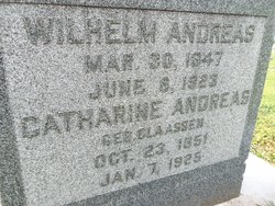

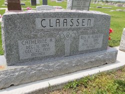
Catherine Claassen Andreas
| Birth | : | 23 Oct 1851 Pomorskie, Poland |
| Death | : | 7 Jan 1925 Gage County, Nebraska, USA |
| Burial | : | Rose Hill Cemetery, Berrien Springs, Berrien County, USA |
| Coordinate | : | 41.9331017, -86.3403015 |
| Plot | : | L-34 |
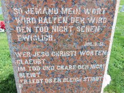
| Inscription | : | Below is written John 14:19 in German "Ich lebe und Ihr sollt auch Leben" (I live and you also will live). On the back is a faded German inscription which is, I think, "Sei gehen bis an den Tod so will ich dir drei Krone des |
| Description | : | Catharine (Claassen) Andreas, 73 October 23, 1851 ~ January 7, 1925 Catharine was born October 23, 1851 in Klein Lichtenau, West Prussia. She came to the United States, settling near Beatrice, Nebraska, and died January 7, 1925 in Beatrice. After World War I, Germany was parceled out, without respect to languages spoken by the people. West Prussia was part of Germany, and the family spoke Hoch Deutsch (High German, the written language). ~~~~~~~~~~~~~~~~~~~~~~~~~~~~ A Note on Sources There seems to be some confusion with the date of death. The on-line Mennonite directory lists January 2, 1925; the... Read More |
frequently asked questions (FAQ):
-
Where is Catherine Claassen Andreas's memorial?
Catherine Claassen Andreas's memorial is located at: Rose Hill Cemetery, Berrien Springs, Berrien County, USA.
-
When did Catherine Claassen Andreas death?
Catherine Claassen Andreas death on 7 Jan 1925 in Gage County, Nebraska, USA
-
Where are the coordinates of the Catherine Claassen Andreas's memorial?
Latitude: 41.9331017
Longitude: -86.3403015
Family Members:
Parent
Spouse

Siblings
Children
Flowers:


Nearby Cemetories:
1. Rose Hill Cemetery
Berrien Springs, Berrien County, USA
Coordinate: 41.9331017, -86.3403015
2. Long Lake Cemetery
Berrien Springs, Berrien County, USA
Coordinate: 41.9185982, -86.3125000
3. Berrien County Poor Farm Cemetery
Berrien Springs, Berrien County, USA
Coordinate: 41.9539700, -86.3028900
4. Burke Cemetery
Berrien Springs, Berrien County, USA
Coordinate: 41.9216995, -86.3974991
5. Union Cemetery
Berrien Center, Berrien County, USA
Coordinate: 41.9299431, -86.2727356
6. Colvin Cemetery
Buchanan, Berrien County, USA
Coordinate: 41.8986110, -86.3944440
7. Oak Grove Cemetery
Oronoko, Berrien County, USA
Coordinate: 41.9241982, -86.4122009
8. Maple Grove Cemetery
Eau Claire, Berrien County, USA
Coordinate: 41.9719009, -86.2872009
9. Caldwell Cemetery
Eau Claire, Berrien County, USA
Coordinate: 41.9860992, -86.2861023
10. Sherwood Cemetery
Buchanan, Berrien County, USA
Coordinate: 41.8669440, -86.3636110
11. Lett Cemetery
Sodus, Berrien County, USA
Coordinate: 42.0038890, -86.3447220
12. Salem Cemetery
Oronoko Township, Berrien County, USA
Coordinate: 41.9644012, -86.4278030
13. Morris Chapel Cemetery
Niles, Berrien County, USA
Coordinate: 41.9063880, -86.2463880
14. Benton Cemetery
Niles, Berrien County, USA
Coordinate: 41.8542190, -86.3501790
15. Feather Cemetery
Hinchman, Berrien County, USA
Coordinate: 41.9720955, -86.4356689
16. Mount Pleasant Cemetery
Sodus Township, Berrien County, USA
Coordinate: 42.0194016, -86.3581009
17. Robert Farry Cemetery
Eau Claire, Berrien County, USA
Coordinate: 42.0002778, -86.2619444
18. Hinman Cemetery
Baroda Township, Berrien County, USA
Coordinate: 41.9272003, -86.4597015
19. Boyle Cemetery
Oronoko, Berrien County, USA
Coordinate: 41.9013889, -86.4527778
20. Johnson Cemetery
Niles, Berrien County, USA
Coordinate: 41.8594440, -86.2691660
21. Harrah Road Cemetery
Niles, Berrien County, USA
Coordinate: 41.8425000, -86.3058333
22. Rodgers Cemetery
Pokagon, Cass County, USA
Coordinate: 41.9169365, -86.2149947
23. Franklin Cemetery
Berrien Township, Berrien County, USA
Coordinate: 41.9711110, -86.2236110
24. Virginians Burying Ground
Buchanan, Berrien County, USA
Coordinate: 41.8373070, -86.3694077