
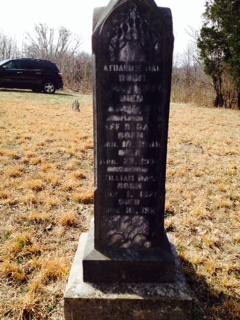
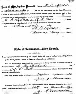
Catherine Marie Mayberry Dale
| Birth | : | 1839 Overton County, Tennessee, USA |
| Death | : | unknown |
| Burial | : | Dale Davis Cemetery, Clay County, USA |
| Coordinate | : | 36.5143600, -85.4685300 |
| Description | : | Mother of Mariah Dale and Hunter Calvin Dale. Hunter is buried in the Tishomingo City Cemetery in Tishomingo, Johnston Co, OK. She was the daughter of Thomas Mayberry. |
frequently asked questions (FAQ):
-
Where is Catherine Marie Mayberry Dale's memorial?
Catherine Marie Mayberry Dale's memorial is located at: Dale Davis Cemetery, Clay County, USA.
-
When did Catherine Marie Mayberry Dale death?
Catherine Marie Mayberry Dale death on unknown in
-
Where are the coordinates of the Catherine Marie Mayberry Dale's memorial?
Latitude: 36.5143600
Longitude: -85.4685300
Family Members:
Spouse
Children
Flowers:


Nearby Cemetories:
1. Dale Davis Cemetery
Clay County, USA
Coordinate: 36.5143600, -85.4685300
2. Walker Cemetery
Celina, Clay County, USA
Coordinate: 36.5372009, -85.4728012
3. Keen Cemetery
Clay County, USA
Coordinate: 36.5116997, -85.4385986
4. Peterman Bend Cemetery
Celina, Clay County, USA
Coordinate: 36.5370750, -85.4846300
5. Robert Arms Cemetery
Pea Ridge, Clay County, USA
Coordinate: 36.5432790, -85.4657820
6. Gates Cemetery
Celina, Clay County, USA
Coordinate: 36.5422640, -85.4891440
7. Tinsley Cemetery
Cave Springs, Clay County, USA
Coordinate: 36.5527992, -85.4800034
8. Smith Family Cemetery
Clay County, USA
Coordinate: 36.5073684, -85.4173430
9. Old Fitzgerald Cemetery
Celina, Clay County, USA
Coordinate: 36.5509750, -85.4958417
10. Fitzgerald Cemetery
Celina, Clay County, USA
Coordinate: 36.5518990, -85.4966965
11. Hamilton Cemetery
Celina, Clay County, USA
Coordinate: 36.5517271, -85.4970509
12. Green Cemetery
Celina, Clay County, USA
Coordinate: 36.5496418, -85.5024450
13. McDonald Cemetery
Baptist Ridge, Clay County, USA
Coordinate: 36.4855995, -85.5119019
14. Rich Cemetery
Baptist Ridge, Clay County, USA
Coordinate: 36.4757080, -85.4991700
15. Page Family Cemetery
Free Hill, Clay County, USA
Coordinate: 36.5623018, -85.4844294
16. Buford Cemetery
Clay County, USA
Coordinate: 36.5405998, -85.4139023
17. Emberton Cemetery
Celina, Clay County, USA
Coordinate: 36.4862150, -85.5237040
18. Hamilton Cemetery
Clay County, USA
Coordinate: 36.5181007, -85.5338974
19. Free Hill Cemetery
Clay County, USA
Coordinate: 36.5628014, -85.4955978
20. McFerrin Cemetery
Overton County, USA
Coordinate: 36.4902992, -85.4075012
21. M R Cemetery
Baptist Ridge, Clay County, USA
Coordinate: 36.4769100, -85.5196770
22. Burchett Cemetery
Overton County, USA
Coordinate: 36.4925003, -85.4041977
23. Hall Cemetery
Clay County, USA
Coordinate: 36.4994011, -85.5366974
24. Doc Hall Cemetery
Clay County, USA
Coordinate: 36.4995390, -85.5369270