
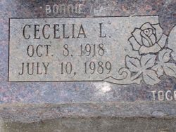
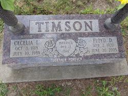
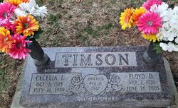
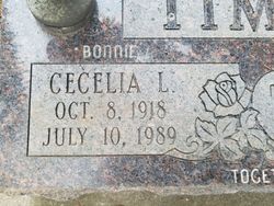
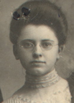
Cecelia LaVonne “Bonnie” Holmes Timson
| Birth | : | 8 Oct 1918 Crookston, Cherry County, Nebraska, USA |
| Death | : | 10 Jul 1989 Red Oak, Montgomery County, Iowa, USA |
| Burial | : | Farm Creek Cemetery, Henderson, Mills County, USA |
| Coordinate | : | 41.1319008, -95.4186020 |
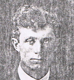
| Description | : | Cecelia Timson, 70, Henderson Funeral services for Cecelia L. "Bonnie" Timson, 70, of Henderson were held July 14 at the Henderson United Methodist Church. The Revs Steve Wainwright and Mel Smith officiated, with burial in Farm Creek Cemetery. Mrs. Timson passed away July 10,1989, in Red Oak. She was born October 8, 1918, in Crookston, Neb., the daughter of Robert and Cecelia Goodwin Holmes. She graduated from high school in Wiggle Creek, (Sherman Co), NE. She married Floyd Timson on April 13, 1942, in Ord, (Valley Co), NE. To this union three children were born. After the couple moved to Iowa, Bonnie owned and... Read More |
frequently asked questions (FAQ):
-
Where is Cecelia LaVonne “Bonnie” Holmes Timson's memorial?
Cecelia LaVonne “Bonnie” Holmes Timson's memorial is located at: Farm Creek Cemetery, Henderson, Mills County, USA.
-
When did Cecelia LaVonne “Bonnie” Holmes Timson death?
Cecelia LaVonne “Bonnie” Holmes Timson death on 10 Jul 1989 in Red Oak, Montgomery County, Iowa, USA
-
Where are the coordinates of the Cecelia LaVonne “Bonnie” Holmes Timson's memorial?
Latitude: 41.1319008
Longitude: -95.4186020
Family Members:
Parent
Spouse
Siblings
Children
Flowers:


Nearby Cemetories:
1. Farm Creek Cemetery
Henderson, Mills County, USA
Coordinate: 41.1319008, -95.4186020
2. Saylers Farm Cemetery
Henderson, Mills County, USA
Coordinate: 41.1083300, -95.4919440
3. Macedonia Cemetery
Macedonia, Pottawattamie County, USA
Coordinate: 41.1921997, -95.4167023
4. Buckner Cemetery
Wales, Montgomery County, USA
Coordinate: 41.1595600, -95.3440700
5. Wesley Chapel Cemetery
Henderson, Mills County, USA
Coordinate: 41.1019249, -95.4987793
6. Old Town Cemetery
Macedonia, Pottawattamie County, USA
Coordinate: 41.2030983, -95.4421997
7. Mormon Cemetery
Macedonia, Pottawattamie County, USA
Coordinate: 41.1885986, -95.3557663
8. Gomer Cemetery
Wales, Montgomery County, USA
Coordinate: 41.1171989, -95.3082962
9. Lowens Cemetery
Garfield Township, Montgomery County, USA
Coordinate: 41.0527728, -95.3758292
10. Cotten Cemetery
Mills County, USA
Coordinate: 41.0845000, -95.5167000
11. Bradway Farm Cemetery
Macedonia, Pottawattamie County, USA
Coordinate: 41.2083300, -95.3336500
12. Emerson Cemetery
Emerson, Mills County, USA
Coordinate: 41.0325012, -95.4021988
13. Wheeler Grove Cemetery
Macedonia, Pottawattamie County, USA
Coordinate: 41.2131691, -95.3393631
14. Center Ridge Cemetery
Montgomery County, USA
Coordinate: 41.1452141, -95.2787018
15. Carson Cemetery
Carson, Pottawattamie County, USA
Coordinate: 41.2392006, -95.4044037
16. North Grove Cemetery
Hastings, Mills County, USA
Coordinate: 41.0161018, -95.4618988
17. Wearin Cemetery
Malvern, Mills County, USA
Coordinate: 41.0395000, -95.5313000
18. Hastings Cemetery
Hastings, Mills County, USA
Coordinate: 41.0097008, -95.4993973
19. L Laire Property Cemetery (Defunct)
Sherman Township, Montgomery County, USA
Coordinate: 41.0958257, -95.2224927
20. East Liberty Cemetery
Malvern, Mills County, USA
Coordinate: 41.0592346, -95.6005020
21. Belknap Cemetery
Oakland, Pottawattamie County, USA
Coordinate: 41.2924995, -95.4424973
22. South Grove Cemetery
Mills County, USA
Coordinate: 40.9775009, -95.4931030
23. Silver City Cemetery
Silver City, Mills County, USA
Coordinate: 41.1042442, -95.6380005
24. Saint Marys Cemetery
Red Oak, Montgomery County, USA
Coordinate: 41.0447006, -95.2275009