
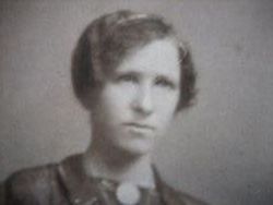


Cecilia “Tillie” Kukrall Kubal
| Birth | : | 24 Oct 1896 Tabor, Bon Homme County, South Dakota, USA |
| Death | : | 1983 |
| Burial | : | Wolvercote Cemetery, Oxford, City of Oxford, England |
| Coordinate | : | 51.7913666, -1.2721500 |
| Description | : | Daughter of Joseph and Rosalia (Carda) Kukrall. Cecilia was born October 24, 1896 in Tabor, SD. She was baptised at St. Wenceslaus Catholic Church on November 6th, 1896. She married Joseph Kubal on May 26th, 1914 at St. Ann's Catholic Church in Geddes, SD. The couple farmed in both SD, and Montana. They had 2 children. |
frequently asked questions (FAQ):
-
Where is Cecilia “Tillie” Kukrall Kubal's memorial?
Cecilia “Tillie” Kukrall Kubal's memorial is located at: Wolvercote Cemetery, Oxford, City of Oxford, England.
-
When did Cecilia “Tillie” Kukrall Kubal death?
Cecilia “Tillie” Kukrall Kubal death on 1983 in
-
Where are the coordinates of the Cecilia “Tillie” Kukrall Kubal's memorial?
Latitude: 51.7913666
Longitude: -1.2721500
Family Members:
Parent
Spouse
Siblings


Children

Flowers:


Nearby Cemetories:
1. Wolvercote Cemetery
Oxford, City of Oxford, England
Coordinate: 51.7913666, -1.2721500
2. St. Peter Churchyard
Wolvercote, City of Oxford, England
Coordinate: 51.7848300, -1.2811100
3. St Michael and All Angels Summertown
Oxford, City of Oxford, England
Coordinate: 51.7796280, -1.2643940
4. Godstow Abbey Ruins
Oxford, City of Oxford, England
Coordinate: 51.7784060, -1.2998170
5. St. Bartholomew's Churchyard
Yarnton, Cherwell District, England
Coordinate: 51.8016610, -1.3087620
6. Yarnton Cemetery
Yarnton, Cherwell District, England
Coordinate: 51.8004080, -1.3103260
7. St. Nicholas Churchyard
Old Marston, City of Oxford, England
Coordinate: 51.7761340, -1.2373130
8. Saint Margaret of Antioch
City of Oxford, England
Coordinate: 51.7690340, -1.2975900
9. Elsfield Road Cemetery
Old Marston, City of Oxford, England
Coordinate: 51.7752940, -1.2332640
10. St. Sepulchres Cemetery
Oxford, City of Oxford, England
Coordinate: 51.7611110, -1.2694440
11. Wytham Churchyard
Wytham, Vale of White Horse District, England
Coordinate: 51.7736230, -1.3131610
12. Woodeaton Holy Rood Churchyard
Woodeaton, South Oxfordshire District, England
Coordinate: 51.8031620, -1.2257910
13. St Paul's Oxford Cemetery
Oxford, City of Oxford, England
Coordinate: 51.7594590, -1.2648470
14. St Giles Churchyard
Oxford, City of Oxford, England
Coordinate: 51.7591660, -1.2605170
15. Saint Barnabas Church
Oxford, City of Oxford, England
Coordinate: 51.7579620, -1.2697600
16. St Thomas of Canterbury Churchyard
Elsfield, South Oxfordshire District, England
Coordinate: 51.7858680, -1.2178310
17. Mansfield College Chapel
Oxford, City of Oxford, England
Coordinate: 51.7576410, -1.2523340
18. Blackfriars
Oxford, City of Oxford, England
Coordinate: 51.7561210, -1.2602060
19. St Johns College
Oxford, City of Oxford, England
Coordinate: 51.7560820, -1.2589910
20. Wadham College Chapel
Oxford, City of Oxford, England
Coordinate: 51.7560700, -1.2540350
21. Rewley Abbey
Oxford, City of Oxford, England
Coordinate: 51.7543810, -1.2675170
22. Martyrs' Memorial
Oxford, City of Oxford, England
Coordinate: 51.7550900, -1.2590100
23. Kidlington Burial Ground
Kidlington, Cherwell District, England
Coordinate: 51.8266010, -1.2916660
24. Trinity College Chapel
Oxford, City of Oxford, England
Coordinate: 51.7552360, -1.2569620