
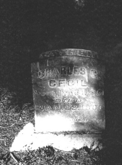
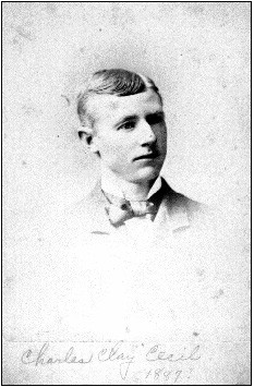
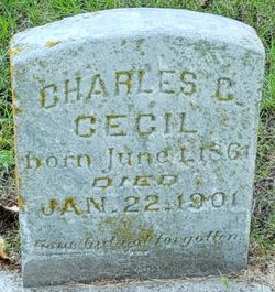
Charles Clay Cecil
| Birth | : | 1 Jan 1861 Monmouth, Warren County, Illinois, USA |
| Death | : | 22 Jan 1901 Douglas County, Nebraska, USA |
| Burial | : | Friends Burial Ground, York, York Unitary Authority, England |
| Coordinate | : | 53.9478920, -1.0618450 |
| Plot | : | Block 7 Lot 84 |
| Description | : | Charles C. Cecil, was the oldest son of William and Isabel (Weaver) Cecil of Monmouth, Illinois. He was married to Nellie Florence Blodgett on June 30, 1887 in Beatrice. They were the parents to five children. He developed stomach cancer and died in a Omaha hospital. Obit. Photocopy of Beatrice newspaper, date and paper not noted. (Photocopy sent by Richard Whipple) Death of Charles Cecil Charles Cecil of this city died in one of the Omaha hospitals Tuesday morning at 4 o'clock from the effects of an operation for cancer. He had been in the hospital some time... Read More |
frequently asked questions (FAQ):
-
Where is Charles Clay Cecil's memorial?
Charles Clay Cecil's memorial is located at: Friends Burial Ground, York, York Unitary Authority, England.
-
When did Charles Clay Cecil death?
Charles Clay Cecil death on 22 Jan 1901 in Douglas County, Nebraska, USA
-
Where are the coordinates of the Charles Clay Cecil's memorial?
Latitude: 53.9478920
Longitude: -1.0618450
Family Members:
Parent
Spouse

Siblings
Children
Flowers:


Nearby Cemetories:
1. Friends Burial Ground
York, York Unitary Authority, England
Coordinate: 53.9478920, -1.0618450
2. York Cemetery
York, York Unitary Authority, England
Coordinate: 53.9503960, -1.0723530
3. St Edward's-without-Walmgate (Defunct)
York, York Unitary Authority, England
Coordinate: 53.9547280, -1.0657383
4. St. Lawrence's Churchyard
York, York Unitary Authority, England
Coordinate: 53.9540530, -1.0688730
5. St Helen Churchyard
York, York Unitary Authority, England
Coordinate: 53.9509330, -1.0753630
6. St Paul Churchyard
Heslington, York Unitary Authority, England
Coordinate: 53.9471780, -1.0445150
7. St George Churchyard
York, York Unitary Authority, England
Coordinate: 53.9548420, -1.0757670
8. St Margaret Churchyard
York, York Unitary Authority, England
Coordinate: 53.9565370, -1.0729530
9. York Castle Prison Cemetery
York, York Unitary Authority, England
Coordinate: 53.9551950, -1.0782660
10. St Denys Churchyard
York, York Unitary Authority, England
Coordinate: 53.9567080, -1.0762240
11. St Clement Priory Churchyard (Defunct)
York, York Unitary Authority, England
Coordinate: 53.9524710, -1.0827970
12. Greyfriars Abbey Church (Defunct)
York, York Unitary Authority, England
Coordinate: 53.9553090, -1.0814240
13. St John Churchyard
York, York Unitary Authority, England
Coordinate: 53.9591850, -1.0761680
14. St Oswald's Old Churchyard
Fulford, York Unitary Authority, England
Coordinate: 53.9391350, -1.0809020
15. St. Mary Castlegate Churchyard
York, York Unitary Authority, England
Coordinate: 53.9570800, -1.0804370
16. All Saints Peasholme (Defunct)
York, York Unitary Authority, England
Coordinate: 53.9597200, -1.0759220
17. St Crux Hungate Burial Ground
York, York Unitary Authority, England
Coordinate: 53.9593540, -1.0774470
18. St Saviour Churchyard
York, York Unitary Authority, England
Coordinate: 53.9596100, -1.0780000
19. All Saints Pavement Churchyard
York, York Unitary Authority, England
Coordinate: 53.9581090, -1.0808820
20. Friends Burial Ground
York, York Unitary Authority, England
Coordinate: 53.9550140, -1.0846700
21. St Crux Churchyard
York, York Unitary Authority, England
Coordinate: 53.9589890, -1.0795460
22. St Cuthbert Churchyard
York, York Unitary Authority, England
Coordinate: 53.9609180, -1.0752310
23. Central Methodist Hall
York, York Unitary Authority, England
Coordinate: 53.9594090, -1.0788330
24. St Clement Church
York, York Unitary Authority, England
Coordinate: 53.9511660, -1.0871720