
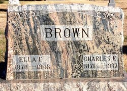
Charles E Brown
| Birth | : | 6 Apr 1871 Zanesville, Muskingum County, Ohio, USA |
| Death | : | 28 Apr 1937 Glasco, Cloud County, Kansas, USA |
| Burial | : | Brookside Cemetery, Bridgewater, Lunenburg County, Canada |
| Coordinate | : | 44.3819400, -64.5285800 |
| Plot | : | 36W23 |
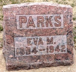
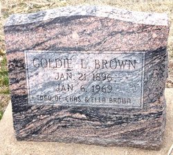
| Description | : | Glasco Sun, May 6, 1937, page 6: Charles E. Brown was born on April 6, 1871 at Zanesville, Ohio, and passed away at his home in Glasco April 28, 1937 at the age of 66 years and 22 days. He was united in marriage to Luella Upjohn, September 8, 1892 at Minneapolis, Kansas; and immediately returned to Glasco where since they have made their home. Surviving are his wife and three children: Mrs. Eva M. Parks, Miss Goldia L. Brown and Roy H. Brown all of Glasco, Kansas; three grandchildren: Mrs. Marie Haines, of Beloit; Neal Parks and Betty Arlene Brown, of Glasco... Read More |
frequently asked questions (FAQ):
-
Where is Charles E Brown's memorial?
Charles E Brown's memorial is located at: Brookside Cemetery, Bridgewater, Lunenburg County, Canada.
-
When did Charles E Brown death?
Charles E Brown death on 28 Apr 1937 in Glasco, Cloud County, Kansas, USA
-
Where are the coordinates of the Charles E Brown's memorial?
Latitude: 44.3819400
Longitude: -64.5285800
Family Members:
Parent
Spouse

Siblings
Children
Flowers:


Nearby Cemetories:
1. Brookside Cemetery
Bridgewater, Lunenburg County, Canada
Coordinate: 44.3819400, -64.5285800
2. Saint Joseph's Catholic Cemetery
Bridgewater, Lunenburg County, Canada
Coordinate: 44.3785600, -64.5303900
3. Holy Trinity Anglican Cemetery
Bridgewater, Lunenburg County, Canada
Coordinate: 44.3726110, -64.5000000
4. Hebbville Cemetery
Hebbville, Lunenburg County, Canada
Coordinate: 44.3510700, -64.5384600
5. Dayspring Community Cemetery
Dayspring, Lunenburg County, Canada
Coordinate: 44.3730300, -64.4808200
6. Maple Leaf Cemetery
Conquerall Bank, Lunenburg County, Canada
Coordinate: 44.3647900, -64.4756700
7. Redeemer Lutheran Church Cemetery
Conquerall Bank, Lunenburg County, Canada
Coordinate: 44.3609139, -64.4577333
8. Acacia Cemetery
Conquerall Bank, Lunenburg County, Canada
Coordinate: 44.3586110, -64.4566670
9. Newcombville Cemetery
Newcombville, Lunenburg County, Canada
Coordinate: 44.3752200, -64.6074600
10. Christ Anglican Church Cemetery
Maitland, Lunenburg County, Canada
Coordinate: 44.4312900, -64.4799300
11. Pleasantville Cemetery New
Pleasantville, Lunenburg County, Canada
Coordinate: 44.3372600, -64.4499600
12. Lake Centre Cemetery
Lake Centre, Lunenburg County, Canada
Coordinate: 44.3142200, -64.4834800
13. Silver Cemetery - Rhodes Corner
Rhodes Corner, Lunenburg County, Canada
Coordinate: 44.3776400, -64.4228700
14. Oakhill Cemetery
Conquerall Mills, Lunenburg County, Canada
Coordinate: 44.3058333, -64.5327777
15. Saint James Anglican Cemetery
Conquerall Mills, Lunenburg County, Canada
Coordinate: 44.3058333, -64.5327777
16. Old Pleasantville Cemetery - Pleasantville
Pleasantville, Lunenburg County, Canada
Coordinate: 44.3358800, -64.4394300
17. Pleasantville Cemetery Old
Pleasantville, Lunenburg County, Canada
Coordinate: 44.3355170, -64.4395810
18. Conquerall Mills Lutheran Church Cemetery
Conquerall Mills, Lunenburg County, Canada
Coordinate: 44.3022220, -64.5413880
19. Saint Matthew's Presbyterian Cemetery
Conquerall Mills, Lunenburg County, Canada
Coordinate: 44.3019440, -64.5419440
20. Mulock Cemetery
Rhodes Corner, Lunenburg County, Canada
Coordinate: 44.3675510, -64.4166670
21. Midville Branch Cemetery
Midville Branch, Lunenburg County, Canada
Coordinate: 44.4215800, -64.6320500
22. Sweetland Cemetery
Sweetland, Lunenburg County, Canada
Coordinate: 44.4682400, -64.5079200
23. Middle LaHave Cemetery
Middle LaHave, Lunenburg County, Canada
Coordinate: 44.3308500, -64.4213000
24. Farmville Cemetery
Farmville, Lunenburg County, Canada
Coordinate: 44.4649900, -64.4690100