
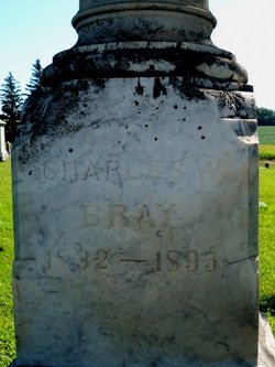
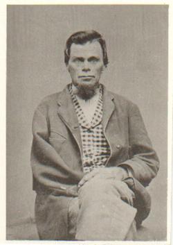
Charles Warden Bray
| Birth | : | 15 Apr 1832 Bristol, Ontario County, New York, USA |
| Death | : | 6 Jul 1895 Syracuse, Otoe County, Nebraska, USA |
| Burial | : | Old School Baptist Churchyard, Rippon, Jefferson County, USA |
| Coordinate | : | 39.2167850, -77.9073720 |
| Description | : | Civil War Veteran Member Wadsworth Post #21 of the GAR |
frequently asked questions (FAQ):
-
Where is Charles Warden Bray's memorial?
Charles Warden Bray's memorial is located at: Old School Baptist Churchyard, Rippon, Jefferson County, USA.
-
When did Charles Warden Bray death?
Charles Warden Bray death on 6 Jul 1895 in Syracuse, Otoe County, Nebraska, USA
-
Where are the coordinates of the Charles Warden Bray's memorial?
Latitude: 39.2167850
Longitude: -77.9073720
Family Members:
Parent
Spouse
Siblings
Children

Flowers:


Nearby Cemetories:
1. Old School Baptist Churchyard
Rippon, Jefferson County, USA
Coordinate: 39.2167850, -77.9073720
2. Lock Family Cemetery
Wheatland, Jefferson County, USA
Coordinate: 39.2273780, -77.8872300
3. Locust Grove Cemetery
Franklintown, Jefferson County, USA
Coordinate: 39.2080990, -77.9307680
4. Burns Family Cemetery
Franklintown, Jefferson County, USA
Coordinate: 39.2077485, -77.9308778
5. Quaker Cemetery
Charles Town, Jefferson County, USA
Coordinate: 39.2442586, -77.9017906
6. Myerstown Cemetery
Jefferson County, USA
Coordinate: 39.2065740, -77.8656560
7. Runnymeade Cemetery
Berryville, Clarke County, USA
Coordinate: 39.1800550, -77.9138230
8. Kabletown Churchyard
Kabletown, Jefferson County, USA
Coordinate: 39.2215881, -77.8597183
9. Lewis Muse Graveyard
Rippon, Jefferson County, USA
Coordinate: 39.1811590, -77.8905340
10. Bullskin Presbyterian Churchyard
Summit Point, Jefferson County, USA
Coordinate: 39.2372940, -77.9578650
11. Peter K. Johnson Farm Graveyard
Charles Town, Jefferson County, USA
Coordinate: 39.2617536, -77.9051369
12. Mount Zion A.M.E. Church Cemetery
Mount Pleasant, Jefferson County, USA
Coordinate: 39.2575322, -77.9485543
13. Wickliffe Episcopal Church Cemetery
Wickliffe, Clarke County, USA
Coordinate: 39.1662090, -77.8913630
14. Fairview Cemetery
Gibsontown, Jefferson County, USA
Coordinate: 39.2695650, -77.8756210
15. Roper Cemetery
Meyerstown, Jefferson County, USA
Coordinate: 39.1695730, -77.8602520
16. Jamestown Cemetery
Summit Point, Jefferson County, USA
Coordinate: 39.2346800, -77.9842300
17. Prosperity Baptist Church Cemetery
Summit Point, Jefferson County, USA
Coordinate: 39.2387730, -77.9843590
18. Crums Cemetery
Berryville, Clarke County, USA
Coordinate: 39.2092018, -78.0018997
19. Cool Spring Catholic Cemetery
Berryville, Clarke County, USA
Coordinate: 39.1463500, -77.8761020
20. Holy Cross Abbey Cemetery
Berryville, Clarke County, USA
Coordinate: 39.1463380, -77.8761020
21. Thomas Blakemore Family Farm Cemetery
Berryville, Clarke County, USA
Coordinate: 39.1724620, -77.9900770
22. Green Hill Cemetery
Berryville, Clarke County, USA
Coordinate: 39.1581001, -77.9768982
23. Stones Chapel Cemetery
Clarke County, USA
Coordinate: 39.2261009, -78.0105972
24. Cool Spring Natural Cemetery
Berryville, Clarke County, USA
Coordinate: 39.1376970, -77.8847300