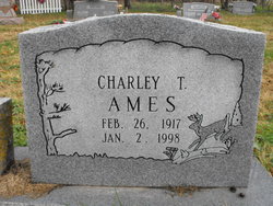
Charley Theodore Ames
| Birth | : | 26 Feb 1917 Eureka Springs, Carroll County, Arkansas, USA |
| Death | : | 2 Jan 1998 Jay, Delaware County, Oklahoma, USA |
| Burial | : | Bethel Lutheran Cemetery, Crow Wing County, USA |
| Coordinate | : | 46.3147200, -94.0827800 |
frequently asked questions (FAQ):
-
Where is Charley Theodore Ames's memorial?
Charley Theodore Ames's memorial is located at: Bethel Lutheran Cemetery, Crow Wing County, USA.
-
When did Charley Theodore Ames death?
Charley Theodore Ames death on 2 Jan 1998 in Jay, Delaware County, Oklahoma, USA
-
Where are the coordinates of the Charley Theodore Ames's memorial?
Latitude: 46.3147200
Longitude: -94.0827800
Family Members:
Parent
Spouse
Siblings
Children
Flowers:
Nearby Cemetories:
1. Bethel Lutheran Cemetery
Crow Wing County, USA
Coordinate: 46.3147200, -94.0827800
2. Vaale Cemetery
Brainerd, Crow Wing County, USA
Coordinate: 46.3224800, -94.0493950
3. Hillside Cemetery
Long Lake Township, Crow Wing County, USA
Coordinate: 46.2577000, -94.1037000
4. Maple Grove Cemetery
Crow Wing County, USA
Coordinate: 46.3297005, -93.9993973
5. Oak Grove Cemetery
Brainerd, Crow Wing County, USA
Coordinate: 46.3485985, -93.9856033
6. Evergreen Cemetery
Brainerd, Crow Wing County, USA
Coordinate: 46.3708000, -94.1859000
7. Crosslake Lutheran Church Columbarium
Crosslake, Crow Wing County, USA
Coordinate: 46.4048300, -94.0650900
8. Saint Pauls Episcopal Church Columbarium
Brainerd, Crow Wing County, USA
Coordinate: 46.3604205, -94.1988906
9. Pine Tree Cemetery
Crow Wing County, USA
Coordinate: 46.2122000, -94.1214000
10. Evergreen Memorial Gardens
Brainerd, Crow Wing County, USA
Coordinate: 46.4010010, -94.1740036
11. Dykeman Union Cemetery
Crow Wing County, USA
Coordinate: 46.2792015, -93.9263992
12. Riverside Cemetery
Crow Wing County, USA
Coordinate: 46.2224998, -94.1893997
13. Baxter Cemetery
Baxter, Crow Wing County, USA
Coordinate: 46.3455600, -94.2855600
14. Saint Mathias Catholic Cemetery
Saint Mathias, Crow Wing County, USA
Coordinate: 46.2200000, -94.2517000
15. Oak Land Cemetery
Crow Wing County, USA
Coordinate: 46.2722015, -94.3043976
16. Woodland Cemetery
Ironton, Crow Wing County, USA
Coordinate: 46.4599991, -93.9880981
17. Bay Lake Cemetery
Deerwood, Crow Wing County, USA
Coordinate: 46.4138000, -93.8730000
18. Lakewood Cemetery
Crosby, Crow Wing County, USA
Coordinate: 46.4625015, -93.9456024
19. Saint John Holy Cross Cemetery
Brainerd, Crow Wing County, USA
Coordinate: 46.2790970, -94.3328890
20. Garrison Cemetery
Garrison, Crow Wing County, USA
Coordinate: 46.3078000, -93.8264000
21. Saint Francis Assisi Cemetery
Brainerd, Crow Wing County, USA
Coordinate: 46.2752980, -94.3352060
22. Pine Grove Cemetery
Crow Wing County, USA
Coordinate: 46.1713000, -94.2725000
23. Dixon Cemetery
Fort Ripley, Crow Wing County, USA
Coordinate: 46.2154930, -94.3246630
24. Oak Hill Cemetery
Crow Wing County, USA
Coordinate: 46.2158012, -94.3285980


