
| Birth | : | 26 Feb 1897 Afton, Union County, Iowa, USA |
| Death | : | 26 Dec 1932 Long Beach, Los Angeles County, California, USA |
| Burial | : | Mount Hope Cemetery, Sandwich, Barnstable County, USA |
| Coordinate | : | 41.7518997, -70.4850006 |
| Plot | : | Angeles Building, Corridor #3, crypt #312 |
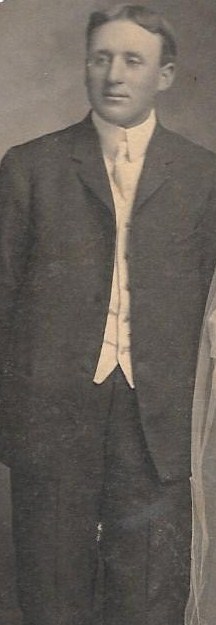
| Description | : | Afton Star Enterprise - 5 Jan 1933 - page 1 Clarence A. Berry was born near Afton, Iowa, Feb. 26, 1897, and passed away Dec. 26, 1932, at his home, 111 Termino Ave., Long Beach, Calif. Clarence grew to young manhood at the fsrm home near Afton and attended Afton high school. He was married to Luella Whittlesey, of Arispe, Iowa, Dec. 23, 1914. Fourteen years ago they moved to Long Beach, Calif., and have since made that city their home. Clarence numbered his friends by his acquaintances. Although he had been in ill health for the past two years,... Read More |
frequently asked questions (FAQ):
-
Where is Clarence Arthur Berry's memorial?
Clarence Arthur Berry's memorial is located at: Mount Hope Cemetery, Sandwich, Barnstable County, USA.
-
When did Clarence Arthur Berry death?
Clarence Arthur Berry death on 26 Dec 1932 in Long Beach, Los Angeles County, California, USA
-
Where are the coordinates of the Clarence Arthur Berry's memorial?
Latitude: 41.7518997
Longitude: -70.4850006
Family Members:
Parent

Spouse
Siblings

Children
Flowers:


Nearby Cemetories:
1. Mount Hope Cemetery
Sandwich, Barnstable County, USA
Coordinate: 41.7518997, -70.4850006
2. Almshouse Burial Ground
Sandwich, Barnstable County, USA
Coordinate: 41.7501000, -70.4847000
3. Spring Hill Cemetery
Sandwich, Barnstable County, USA
Coordinate: 41.7487984, -70.4775009
4. Old Town Cemetery
Sandwich, Barnstable County, USA
Coordinate: 41.7556992, -70.5011978
5. Saint Peters Cemetery
Sandwich, Barnstable County, USA
Coordinate: 41.7502480, -70.5079346
6. Freeman Cemetery
Sandwich, Barnstable County, USA
Coordinate: 41.7573013, -70.5083008
7. Old Quaker Meeting House Cemetery at Spring Hill
Sandwich, Barnstable County, USA
Coordinate: 41.7463100, -70.4613060
8. Bay View Cemetery
Sandwich, Barnstable County, USA
Coordinate: 41.7583008, -70.5102997
9. Quaker Meeting House Cemetery
East Sandwich, Barnstable County, USA
Coordinate: 41.7469673, -70.4591064
10. Saddle and Pillion Cemetery
Sagamore, Barnstable County, USA
Coordinate: 41.7672005, -70.5192032
11. Cedarville Cemetery
East Sandwich, Barnstable County, USA
Coordinate: 41.7397804, -70.4428864
12. Sandwich Town Cemetery
Sandwich, Barnstable County, USA
Coordinate: 41.7125300, -70.4909000
13. Sagamore Cemetery
Bourne, Barnstable County, USA
Coordinate: 41.7714005, -70.5339966
14. Tobey Cemetery
Forestdale, Barnstable County, USA
Coordinate: 41.6972008, -70.4875031
15. Bournedale Burying Hill
Bourne, Barnstable County, USA
Coordinate: 41.7741520, -70.5611730
16. Forestdale Cemetery
Forestdale, Barnstable County, USA
Coordinate: 41.6903000, -70.5024033
17. Percival Cemetery
Sandwich, Barnstable County, USA
Coordinate: 41.6883011, -70.4557037
18. Boardley Road Cemetery
Sandwich, Barnstable County, USA
Coordinate: 41.6870003, -70.4559021
19. Bournedale Herring Pond Indian Cemetery
Bourne, Barnstable County, USA
Coordinate: 41.7861900, -70.5658722
20. Herring Pond Wampanoag Indian Cemetery
Plymouth, Plymouth County, USA
Coordinate: 41.7867290, -70.5658940
21. Francis Family Cemetery
Mashpee, Barnstable County, USA
Coordinate: 41.6807900, -70.4816600
22. Herring Pond Cemetery
Plymouth, Plymouth County, USA
Coordinate: 41.7971700, -70.5588800
23. Cedarville Cemetery
Plymouth, Plymouth County, USA
Coordinate: 41.8049736, -70.5560837
24. Animal Inn Pet Cemetery
Forestdale, Barnstable County, USA
Coordinate: 41.6754200, -70.5070100